FSX California North Central Coast Scenery
 California North Central Coast Scenery for FSX with CCFSXMSG, Megascenery Earth California 10,11,26 & 27, FSGenesis mesh and Eric McCloud's KMRY. This is an expansion of the previously released CCFSXMSG scenery that covered 27 airports/airstrips within the confines of MegaScenery Earth California...
- Download hits
- 708
- Compatibility
- Microsoft Flight Simulator X (FSX) including Steam Edition & Prepar3D (P3D)
- Filename
- ccnfsxmsg.zip
- File size
- 1.31 MB
- Virus Scan
- Scanned 18 days ago (clean)
- Access to file
- Free (Freeware)
- Content Rating
- Everyone
Rated 5 out of 5 stars by 1 PRO members.
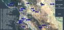
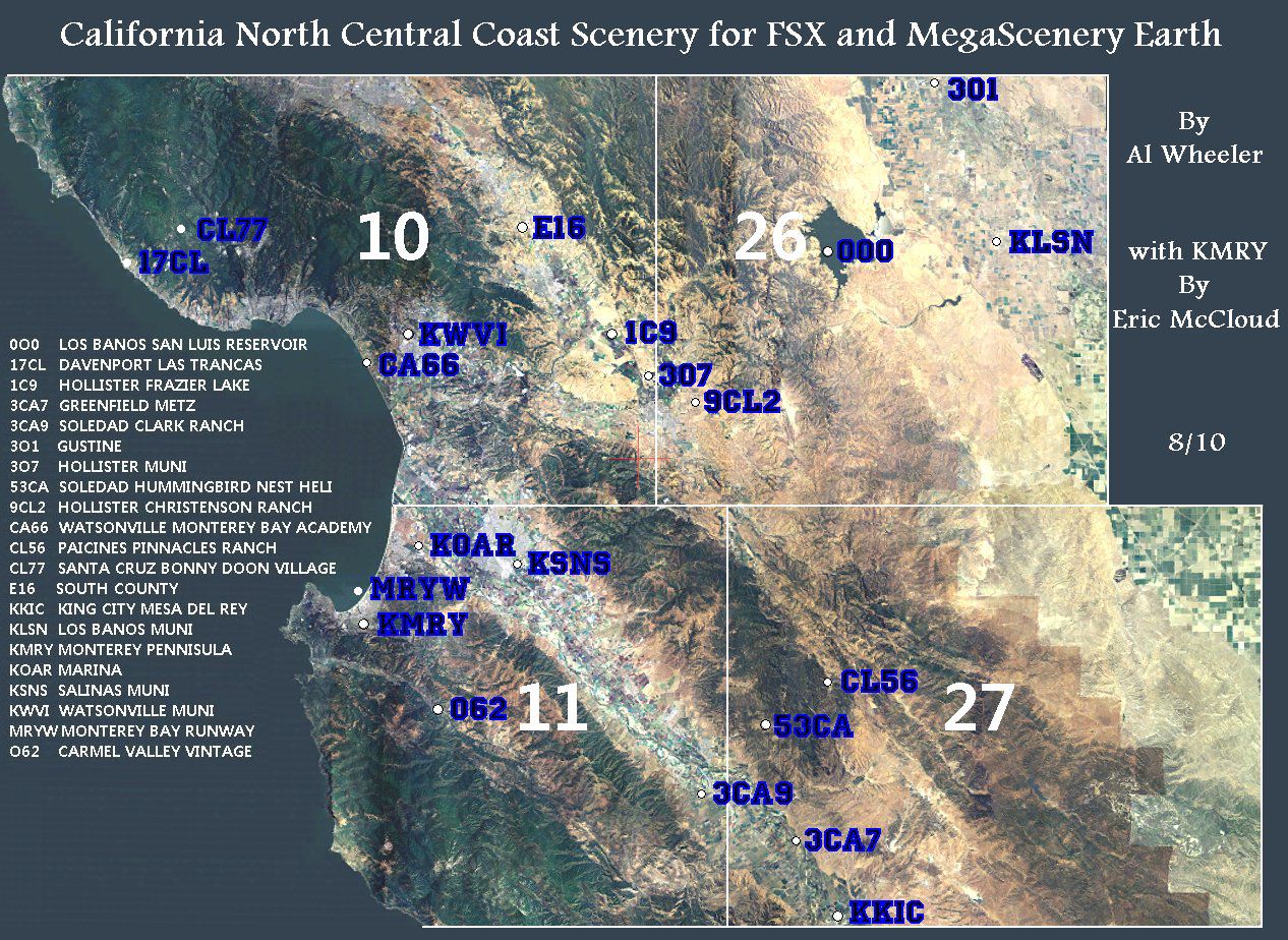
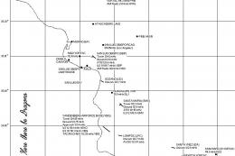
California North Central Coast Scenery for FSX with CCFSXMSG, Megascenery Earth California 10,11,26 & 27, FSGenesis mesh and Eric McCloud's KMRY. This is an expansion of the previously released CCFSXMSG scenery that covered 27 airports/airstrips within the confines of MegaScenery Earth California 12,13,14,15,28 and 29. CCNFSXMSG adds twenty more airstrips/airports north of those regions within the confines of MegaScenery Earth California 10,11,26 and 27. This addition covers roughly from N37° 16' (Gustine) down to N36° 10' (King City) and from the coast East to W120° 42'/120° 28'. By Al Wheeler.
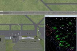
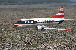
Aerial view of California North Central Coast Scenery.
REQUIREMENTS:
CCFSXMSG must have been installed for this scenery addition to work since many textures, etc. are shared.
MegaScenery Earth California 010, 011, 026, 027
FSGenesis USA 9.6m Terrain Mesh for FSX V2 by Justin Tyme and a mesh resolution setting of 5m or at least 10m is also required for this scenery to display properly.
I don't include scenery for the KMRY Monterey Peninsula airport since Eric McCloud recently released an excellent version of that airport that meshes perfectly with MegaScenery Earth.
FILES INCLUDED in CCNFSXMSG.ZIP:
Readme.DOC DOC format description
Readme.TXT TXT format description
File_ID.DIZ Short description
License.TXT Conditions of use
CCCNAREA.JPG Megascenery texture overview
CCNFSXMSG.GIF Thumbnail of KSNS
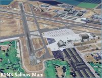
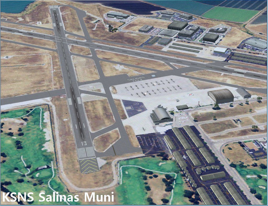
KSNS.JPG KSNS Screenshot
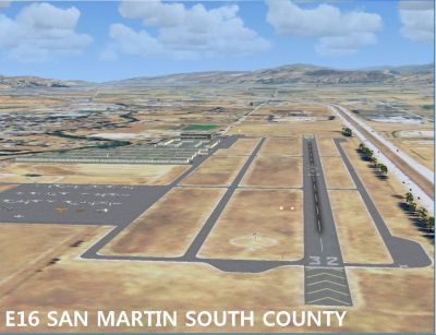
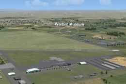
E16.JPG E16 Screenshot
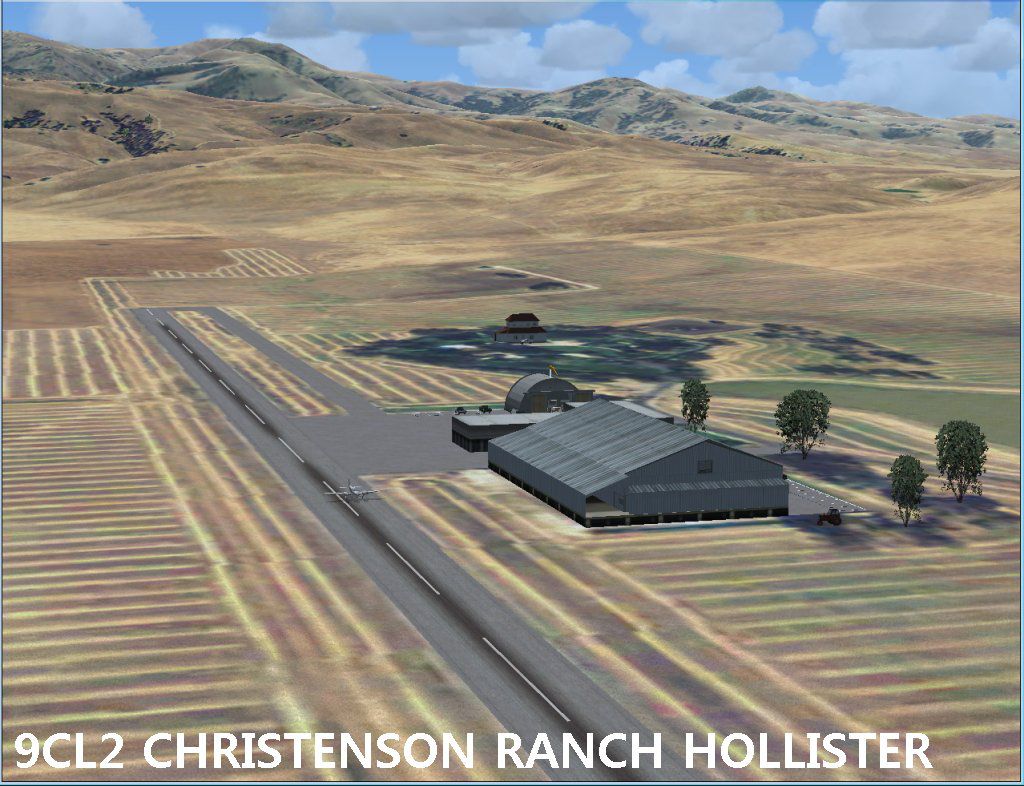
9CL2.JPG 9CL2 Screenshot
CCFSXMSG\Scenery directory 63 BGL scenery files
CCFSXMSG\Texture directory 6 BMP texture files
SCENERY\World\Scenery directory 3 BGL scenery altitude adjustment files
FLIGHTS directory 21 flight FLT files with paired WX files(See NOTES: FLIGHTS)
KSNSAFD\Normal directory 2 BGL KSNS AFD Normal files (See NOTES: CROSSWIND R/W)
KSNSAFD\Xwind directory 2 BGL KSNS AFD Xwind files
This scenery is freeware and may be freely circulated except for profit.
INSTALLATION:
There are several ways to install the files. Shown below is the way I believe is the easiest. Your FSX drive and path is probably different than mine so I do not show the entire path below. If you used the default FSX installation path, where I indicate "FSX" you would use "Flight Simulator FSX" directory. In any case, it's where the FSX.EXE is located.
1) Unzip all the files from CCNFSXMSG.ZIP into a temporary directory. Be sure to allow extraction of pathnames (directories). You will see that four root directories have been created in the temporary directory: CCFSXMSG with subdirectories Scenery and Texture, SCENERY with subdirectory World with its subdirectory Scenery, KSNSAFD with subdirectories Normal and XWind plus FLIGHTS with no associated subdirectories.
2) Open Windows Explorer and drag the CCFSXMSG directory into your FSX\ADDON SCENERY directory. This will add the scenery and texture files to your previously installed CCFSXMSG files. Then drag the SCENERY directory into your FSX directory or you could just copy the 3 BGL altitude adjustment files into your FSX\SCENERY\World\Scenery directory if you'd rather.
3) If not already installed, install Eric McCloud's KMRY Monterey Peninsula scenery per his Readme.TXT instructions and assign his scenery priority to a higher priority than the MegaScenery Earth California scenery. See NOTES: KMRY below.
This completes the installation of the CCNFSXMSG scenery except for the optional flight (.FLT) files.
See NOTES: FLIGHTS regarding those.
NOTES:
KMRY:
Eric McCloud suggests using a mesh resolution setting of 76m with his KMRY Monterey Peninsula scenery. Much of the scenery in CCNFSXMSG and CCFSXMSG involves small airstrips in rolling hills that required a lot of detailed terrain sculpting. For that to look right a mesh resolution of 5m or at least 10m is required. Therefore, included in this scenery is a small file that will minimize any terrain problems near KMRY when using FSGenesis mesh terrain and high (5m or 10m) mesh resolution settings. This file in no way detracts from or modifies McCloud's scenery.
FLIGHTS:
I also included flight files (.FLT and .WX) for 21 CAVU FLIGHTS. These slew the default ultralight aircraft to a viewing point at the various airports/airstrips in this scenery. To use them, move them into your Flight Simulator X Files directory. With Vista this will be your C:\Users\YourUsername\Documents\Flight Simulator X Files directory or in XP it would be C:\Documents and Settings\YourUsername\My Documents\Flight Simulator X Files directory. Each file is named with the appropriate ICAO code preceded with "CCN".
CROSSWIND R/W:
There are three airports in this scenery (KSNS, KWVI and 3O7) with crossing runways. I have enabled them for crosswind traffic in order to utilize the multiple runways for AI traffic. When such an airport has a tower as KSNS does this procedure makes a mess of ATIS transmissions. Therefore, if you'd prefer not to have KSNS crosswind enabled I have included replacement AFD files that remove the crosswind feature for KSNS only. They are included in the KSNSAFD/Normal directory. Just copy them into the CCFSXMSG/Scenery directory allowing overwrites. Copies of the original Xwind AFD files are in the KSNSAFD/Xwind directory if you decide to go back to the Xwind feature at KSNS. KWVI and 3O7 do not have towers or ATIS so there is no downside to their using the crosswind feature.
AI FLIGHT PLANS:
The land based flight plans included with this scenery utilize only default FSX aircraft to keep them universally useable. The AI float planes I used are ZZZA Floatplane Aviat Husky and ZZZA Floatplane Waco Classic from Holger Sandmann's ai_float.zip that I recommended that you install in the CCFSXMSG readme file. If you don't want to use these flight plans you could remove or disable the Traffic_NCC_FSX.BGL file that's now in the CCFSXMSG/Scenery directory but with only the default AI you'll have minimal to non-existent AI traffic at the 10 Public Airports and none at the 10 airstrips in this release.
The AI flight plans consist of 60 AI flights originating at 20 CCNFSXMSG airports/airstrips (excluding the 53CA heliport). There are departures beginning at 00:00Z that repeat every 2 hours. In order to have some control over the level of CCC AI flights I assigned Active Level percentages as follows:
4% All Float plane traffic including T&G
10% AI activity at CCN airports
15% AI touch and goes (except float planes)
PUBLIC AIRPORTS:
KMRY Monterey Peninsula (by Eric McCloud) 257' MSL, N36°35.22', W121°50.58' :
Two controlled runways: 10R/28L 7,608x144' and 10L/28R 3,510x65'.
KMRY Area NavAids/Comm:
LOC/DME R/W 28L 110.70 MHz I-MTB
ILS/DME/MM/OM R/W 10R 110.70 MHz I-MRY
NDB 385.00 KHz MR Munso (at OM)
Tower 118.40 MHz Monterey Tower
Ground Control 121.90 MHz Monterey Ground
ATIS 119.25 MHz Monterey
Unicom 122.95 MHz Monterey Peninsula
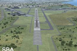
KSNS Salinas 84' MSL, N36°39.77', W121°36.38' :
Three controlled runways: 08/26 6,002X150', 13/31 4,840x150' and 14/32 1900x50'. SNS VORTAC is located on the field.
KSNS Area NavAids/Comm:
ILS/MM/OM R/W 31 108.50 MHz I-SNS
NDB 263.00 KHz UAD Chualar (Salinas)
Tower 119.40 MHz Salinas Tower
Ground Control 121.70 MHz Salinas Ground
UNICOM 122.95 MHz Salinas Muni
ATIS 124.85 MHz Salinas
ASOS 124.85 MHz Salinas
Salinas VORTAC 117.30 MHz SNS on the field
KWVI Watsonville Muni 160' MSL, N36°56.14' W121°47.38' :
Two uncontrolled runways: 02/20 4,502x150' and 08/26 3,994x100'.
KWVI Area NavAids/Comm:
LOC/OM R/W 02 108.30 MHz I-AYN
NDB 327 KHz PDG Pajar (at OM)
ASOS 132.175 MHz Watsonville
Unicom 122.80 MHz Watsonville Muni
1C9 Hollister Frazier Lake 151' MSL N36°57.20' W121°27.93' :
Two uncontrolled runways: 05L/23R 2,650x110' Grass and 05W/23W 2,990x100' Water
1C9 Comm:
Unicom 123.05 MHz Frazier Lake
3O1 Gustine 75' MSL N37°15.76' W120°57.80' :
One uncontrolled runway: 18/36 3,210x60' :
3O1 Comm:
Multicom 122.90 MHz Gustine
3O7 Hollister Muni 230' MSL, N36°53.60' W121°24.62' :
Two uncontrolled runways: 13/31 6,395x100' and 3,251x100' :
3O7 Comm:
Unicom 123.00 MHz Hollister Muni
E16 South County 281' MSL, N37°04.90' W121°35.83' :
One uncontrolled runway: 14/32 3,103x73'
E16 Comm:
Unicom 122.70 MHz South County of Santa Clara
KKIC King City Mesa Del Rey 370' MSL, N36°13.68' W121°07.31' :
One uncontrolled runway: 11/29 4,485x100'
KKIC Comm:
Multicom 122.90 MHz Mesa Del Rey
KLSN Los Banos Muni 119' MSL N37°03.77' W120°52.16' :
One uncontrolled runway: 14/32 3,795x75' :
KLSN Comm:
Unicom 122.80 MHz Los Banos Muni
KOAR Marina 134' MSL, N36°40.91' W121°45.75' :
One uncontrolled runway: 11/29 3,500x75' :
KOAR Comm:
Unicom 122.70 MHz Marina
PRIVATE OR RESTRICTED AIRSTRIPS:
0O0 Los Banos San Luis Reservoir 544' MSL, N37°03.50' W121°07.56' E/W 5,000x300' Water
3CA7 Greenfield Metz 240' MSL, N36°19.70' W121°11.20' 15/33 3,500x70'
3CA9 Soledad Clark Ranch 243' MSL, N36°21.80' W121°18.61' 13/31 2,360x60'
9CL2 Hollister Christensen Ranch 380' MSL, N36°52.30' W121°20.23' 07/25 3,016x50' Marked "R" Asphalt
17CL Davenport Las Trancas 131' MSL, N37°05.28' W122°16.42' 14/32 910x30'
53CA Soledad Hummingbird Nest Heliport 1,680' MSL N36°28.00' W121°14.11' 07/25 1,750x35' Heli's only
CL56 Paicines Pinnacles Ranch 1,143' MSL, N36°30.62' W121°08.11' N/S 3,050x50'
CL77 Santa Cruz Bonny Doon Village 2,020' MSL, N37°04.23' W122°07.65' 12/30 2,390x40'
CA66 Watsonville Monterey Bay Academy 70' MSL, N36°54.36' W121°50.58' 10/28 2,320x90'
O62 Carmel Valley Vintage 450' MSL, N36°28.91' W121°43.81' 11/29 1,780x45' Marked "X"
MRYW Fictional Monterey Bay runway 0' MSL, N36°36.6' W121°51.96' E/W 5,000X300' Water
Airstrip Notes: Some airstrip parameters (runway heading, length, width, surface etc.) do not agree with FSX default data but were determined by matching satellite textures. All these strips are probably restricted or closed but are usable in FSX for AI and/or free flight.
CREDITS:
This scenery was constructed using:
Custom night lighting are by Jim Dhaenens
Animated windsock by J.D. Bert, Jon Patch and Arno Gerretsen
Library Creator XML 1.2.22 by Arno Gerretsen
TCalcX by Dick Ludowise
Chainlink gate textures by Michael Rodriquez
Airport Design Editor (ADE) V1.40.7 by ScruffyDuck Software
SBuilderX V3.10 by Luis Sa
AI Flight Planner by Don Grovestine (AI Flight Plans)
FS Design Studio V3.5.1 by Louis Sinclair.
FSX SDK
Google Earth
COMMENTS:
Display settings I'm using:
I don't like autogen buildings when flying photoreal scenery. They don't look realistic to me at altitude and are frequently poorly placed and I have fairly appropriate structures placed on or close to airports in this scenery. Therefore I edit my FSX.CFG file as follows: TERRAIN_MAX_AUTOGEN_BUILDINGS_PER_CELL=000. This kills all autogen buildings without disturbing autogen trees or surf.
The other settings I use are as follows:
Level of detail radius: Large
Mesh complexity: 100
Mesh resolution: 5 m
Texture resolution: 1 m
Water effects: Low 2.x
Scenery complexity: Extremely dense (Usually OK when flying in low density areas such as CCC)
Autogen density: Normal (Anything below Sparse kills surf)
Special effects detail: High
Land detail textures: Checked
Ground scenery shadows: Unchecked
Road traffic density: 25-30 (Reasonably density for this area)
These settings are not suggestions or even recommendations but what works for me on my middle of the road system.
Al Wheeler
Aerial view of California North Central Coast Scenery.
Images & Screenshots

The archive ccnfsxmsg.zip has 139 files and directories contained within it.
File Contents
This list displays the first 500 files in the package. If the package has more, you will need to download it to view them.
| Filename/Directory | File Date | File Size |
|---|---|---|
| 9CL2.jpg | 09.09.10 | 163.38 kB |
| CCCNAREA.jpg | 08.23.10 | 390.11 kB |
| CCFSXMSG | 09.10.10 | 0 B |
| Scenery | 09.15.10 | 0 B |
| 0O0_ADEX_AW.BGL | 08.05.10 | 2.54 kB |
| 17CL_ADEX_AW.BGL | 09.06.10 | 942 B |
| 17CL_ADEX_AW_CVX.bgl | 09.06.10 | 1.32 kB |
| 17CLobj.bgl | 09.11.10 | 636 B |
| 1C9_ADEX_AW.BGL | 09.11.10 | 5.44 kB |
| 1C9_ADEX_AW_CVX.bgl | 09.11.10 | 228 B |
| 1C9obj.bgl | 09.11.10 | 3.37 kB |
| 1C9W_ADEX_AW.BGL | 08.09.10 | 1.32 kB |
| 3CA7_ADEX_AW.BGL | 09.11.10 | 1.09 kB |
| 3CA7_ADEX_AW_CVX.bgl | 09.11.10 | 628 B |
| 3CA7obj.bgl | 09.11.10 | 1.07 kB |
| 3CA9_ADEX_AW.BGL | 09.06.10 | 1.16 kB |
| 3CA9_ADEX_AW_CVX.bgl | 09.06.10 | 1.67 kB |
| 3CA9obj.bgl | 09.11.10 | 716 B |
| 3O1_ADEX_AW.BGL | 09.11.10 | 4.05 kB |
| 3O1_ADEX_AW_CVX.bgl | 09.11.10 | 421 B |
| 3O1obj.bgl | 09.11.10 | 1.54 kB |
| 3O7_ADEX_AW_X.BGL | 09.11.10 | 14.33 kB |
| 3O7_ADEX_AW_X_CVX.bgl | 09.11.10 | 678 B |
| 3O7obj.bgl | 09.11.10 | 2.78 kB |
| 53CA_ADEX_AW.BGL | 08.01.10 | 622 B |
| 53CA_ADEX_AW_CVX.bgl | 08.01.10 | 1.58 kB |
| 53CAobj.bgl | 09.11.10 | 764 B |
| 9CL2_ADEX_AW.BGL | 09.11.10 | 2.11 kB |
| 9CL2_ADEX_AW_CVX.bgl | 09.11.10 | 1.78 kB |
| 9CL2obj.bgl | 09.11.10 | 1.26 kB |
| CA66_ADEX_AW.BGL | 09.11.10 | 1.36 kB |
| CA66_ADEX_AW_CVX.bgl | 09.11.10 | 1.72 kB |
| CA66obj.bgl | 09.11.10 | 1004 B |
| CCCBuoysobj.bgl | 09.08.10 | 3.61 kB |
| CCNLIB.bgl | 08.19.10 | 12.54 kB |
| CL56_ADEX_AW.BGL | 09.11.10 | 1.35 kB |
| CL56_ADEX_AW_CVX.bgl | 09.11.10 | 2.45 kB |
| CL56obj.bgl | 09.11.10 | 812 B |
| CL77_ADEX_AW.BGL | 09.11.10 | 1.61 kB |
| CL77_ADEX_AW_CVX.bgl | 09.11.10 | 1.25 kB |
| CL77obj.bgl | 09.11.10 | 764 B |
| CVX_3O7Exclude.BGL | 08.26.10 | 683 B |
| CVX_KMRYFlatten.bgl | 08.29.10 | 1.59 kB |
| CVX_Pinnacles.BGL | 08.26.10 | 228 B |
| E16_ADEX_AW.BGL | 09.11.10 | 10.16 kB |
| E16_ADEX_AW_CVX.bgl | 09.11.10 | 251 B |
| E16obj.bgl | 09.11.10 | 3.93 kB |
| KKIC_ADEX_AW.BGL | 09.11.10 | 8.98 kB |
| KKIC_ADEX_AW_CVX.bgl | 09.11.10 | 1.32 kB |
| KKICobj.bgl | 09.11.10 | 1.40 kB |
| KLSN_ADEX_AW.BGL | 09.11.10 | 9.20 kB |
| KLSN_ADEX_AW_CVX.bgl | 09.11.10 | 251 B |
| KLSNobj.bgl | 09.11.10 | 2.34 kB |
| KOAR_ADEX_AW.BGL | 09.11.10 | 18.10 kB |
| KOAR_ADEX_AW_CVX.bgl | 09.11.10 | 1.06 kB |
| KOARobj.bgl | 09.11.10 | 2.43 kB |
| KSNS_ADEX_AW.BGL | 09.11.10 | 33.20 kB |
| KSNS_ADEX_AW_CVX.bgl | 09.11.10 | 467 B |
| KSNSobj.bgl | 09.11.10 | 7.68 kB |
| KWVI_ADEX_AW_X.BGL | 09.11.10 | 21.41 kB |
| KWVI_ADEX_AW_X_CVX.bgl | 09.11.10 | 524 B |
| KWVIobj.bgl | 09.11.10 | 3.14 kB |
| MRYW_ADEX_AW.BGL | 08.05.10 | 2.31 kB |
| O62_ADEX_AW.BGL | 09.11.10 | 1.88 kB |
| O62_ADEX_AW_CVX.bgl | 09.11.10 | 1.39 kB |
| O62obj.bgl | 09.11.10 | 1.45 kB |
| Traffic_NCC_FSX.bgl | 09.08.10 | 6.48 kB |
| Texture | 09.09.10 | 0 B |
| APSIGNSCCN.BMP | 08.19.10 | 341.43 kB |
| APSIGNSCCN2.BMP | 08.19.10 | 341.43 kB |
| SEGCIRCM.bmp | 06.29.10 | 341.43 kB |
| SEGCIRCsns.bmp | 07.11.10 | 341.43 kB |
| SEGLFTRITE.bmp | 08.02.10 | 341.43 kB |
| SNSCOMPASS.bmp | 07.11.10 | 341.43 kB |
| CCNFSXMSG.GIF | 09.09.10 | 18.79 kB |
| E16.jpg | 09.09.10 | 149.28 kB |
| File_ID.DIZ | 09.13.10 | 634 B |
| FLIGHTS | 09.09.10 | 0 B |
| CCN0O0.FLT | 09.13.10 | 8.72 kB |
| CCN0O0.WX | 09.13.10 | 152.33 kB |
| CCN17CL.FLT | 09.13.10 | 8.71 kB |
| CCN17CL.WX | 09.13.10 | 153.30 kB |
| CCN1C9.FLT | 09.13.10 | 8.71 kB |
| CCN1C9.WX | 09.12.10 | 152.76 kB |
| CCN3CA7.FLT | 09.13.10 | 8.71 kB |
| CCN3CA7.WX | 09.12.10 | 152.55 kB |
| CCN3CA9.FLT | 09.13.10 | 8.71 kB |
| CCN3CA9.WX | 09.12.10 | 152.55 kB |
| CCN3O1.FLT | 09.13.10 | 8.71 kB |
| CCN3O1.WX | 09.13.10 | 152.50 kB |
| CCN3O7.FLT | 09.13.10 | 8.72 kB |
| CCN3O7.WX | 09.13.10 | 152.52 kB |
| CCN53CA.FLT | 09.13.10 | 8.73 kB |
| CCN53CA.WX | 09.13.10 | 152.44 kB |
| CCN9CL2.FLT | 09.13.10 | 8.72 kB |
| CCN9CL2.WX | 09.13.10 | 152.57 kB |
| CCNCA66.FLT | 09.13.10 | 8.72 kB |
| CCNCA66.WX | 09.13.10 | 152.55 kB |
| CCNCL56.FLT | 09.13.10 | 8.72 kB |
| CCNCL56.WX | 09.13.10 | 152.55 kB |
| CCNCL77.FLT | 09.13.10 | 8.72 kB |
| CCNCL77.WX | 09.13.10 | 152.55 kB |
| CCNE16.FLT | 09.13.10 | 8.71 kB |
| CCNE16.WX | 09.13.10 | 152.55 kB |
| CCNKKIC.FLT | 09.13.10 | 8.71 kB |
| CCNKKIC.WX | 09.13.10 | 152.55 kB |
| CCNKLSN.FLT | 09.13.10 | 8.72 kB |
| CCNKLSN.WX | 09.13.10 | 152.33 kB |
| CCNKMRY.FLT | 09.13.10 | 8.71 kB |
| CCNKMRY.WX | 09.13.10 | 152.78 kB |
| CCNKOAR.FLT | 09.13.10 | 8.70 kB |
| CCNKOAR.WX | 09.13.10 | 152.78 kB |
| CCNKSNS.FLT | 09.13.10 | 8.71 kB |
| CCNKSNS.WX | 09.13.10 | 152.44 kB |
| CCNKWVI.FLT | 09.13.10 | 8.71 kB |
| CCNKWVI.WX | 09.13.10 | 152.67 kB |
| CCNMRYW.FLT | 09.13.10 | 8.73 kB |
| CCNMRYW.WX | 09.13.10 | 152.67 kB |
| CCNO62.FLT | 09.13.10 | 8.72 kB |
| CCNO62.WX | 09.13.10 | 152.50 kB |
| KSNS.jpg | 09.09.10 | 195.38 kB |
| KSNSAFD | 09.15.10 | 0 B |
| Normal | 09.15.10 | 0 B |
| KSNS_ADEX_AW.BGL | 09.11.10 | 32.90 kB |
| KSNS_ADEX_AW_CVX.bgl | 09.11.10 | 467 B |
| XWind | 09.15.10 | 0 B |
| KSNS_ADEX_AW.BGL | 09.11.10 | 33.20 kB |
| KSNS_ADEX_AW_CVX.bgl | 09.11.10 | 467 B |
| License.TXT | 09.10.10 | 886 B |
| ReadMe.doc | 09.15.10 | 17.16 kB |
| ReadMe.txt | 09.15.10 | 12.14 kB |
| SCENERY | 09.09.10 | 0 B |
| WORLD | 09.09.10 | 0 B |
| SCENERY | 09.09.10 | 0 B |
| 17CL_ADEX_AW_ALT.BGL | 09.06.10 | 414 B |
| 3CA9_ADEX_AW_ALT.BGL | 09.06.10 | 412 B |
| CL56_ADEX_AW_ALT.BGL | 09.11.10 | 421 B |
| flyawaysimulation.txt | 10.29.13 | 959 B |
| Go to Fly Away Simulation.url | 01.22.16 | 52 B |
Installation Instructions
Most of the freeware add-on aircraft and scenery packages in our file library come with easy installation instructions which you can read above in the file description. For further installation help, please see our Flight School for our full range of tutorials or view the README file contained within the download. If in doubt, you may also ask a question or view existing answers in our dedicated Q&A forum.
0 comments
Leave a Response