FS2004 London Stansted Airport (EGSS) Scenery
 London Stansted Airport V7.0 for FS2004
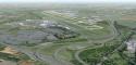
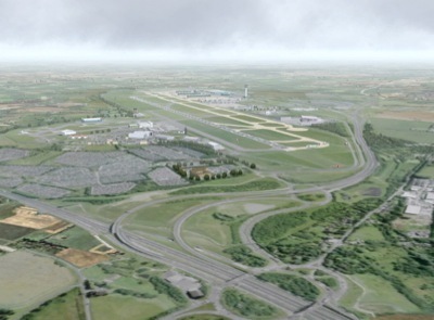
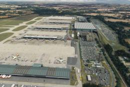
by John Young. A very detailed rendition of London Stansted airport that includes
ground textures derived directly from a composite aerial photograph
produced and copyrighted by The Geoinformation Group Ltd and downloaded
from Google Earth. My thanks t...
London Stansted Airport V7.0 for FS2004
by John Young. A very detailed rendition of London Stansted airport that includes
ground textures derived directly from a composite aerial photograph
produced and copyrighted by The Geoinformation Group Ltd and downloaded
from Google Earth. My thanks t...
- Download hits
- 8.7K
- Compatibility
- FS2004
- Filename
- egssjy7.zip
- File size
- 4.51 MB
- Virus Scan
- Scanned 17 days ago (clean)
- Access to file
- Free (Freeware)
- Content Rating
- Everyone
Rated 5 out of 5 stars by 1 PRO members.
Although the aerial photograph provides the basis of the airport 2-D layout, the scenery is also aligned to the surrounding road system provided by the "Ultimate Terrain Europe" commercial add-on from Flight 1 Software. However, the scenery can still be used with the FS2004 default though some surrounding road detail will be lacking. The scenery is demanding on processor power but omission of some detail is possible and - see below for options.
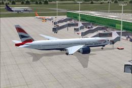
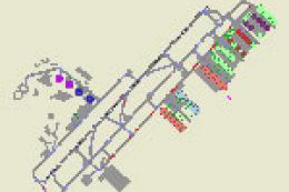
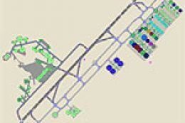
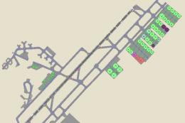
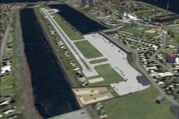
Images & Screenshots

The archive egssjy7.zip has 243 files and directories contained within it.
File Contents
This list displays the first 500 files in the package. If the package has more, you will need to download it to view them.
| Filename/Directory | File Date | File Size |
|---|---|---|
| Windsock_EGSS3.BGL | 05.30.06 | 138 B |
| AF2_EGSS.bgl | 08.12.06 | 10.54 kB |
| EGSS_3D.bgl | 08.11.06 | 629.29 kB |
| EGSS_exclude.bgl | 02.13.03 | 148 B |
| EGSS_smooth2.bgl | 08.10.06 | 524 B |
| EGSS_structures_library.bgl | 07.25.06 | 367.47 kB |
| EGSS_TREES.bgl | 08.10.06 | 32.45 kB |
| EGSSdock.bgl | 04.21.03 | 54.39 kB |
| EGSSfnce.bgl | 08.08.06 | 30.44 kB |
| EGSSlayout.bgl | 08.10.06 | 727.83 kB |
| EGSSvehs.bgl | 08.08.06 | 243.29 kB |
| Stansted Ground.bgl | 08.06.06 | 1.85 kB |
| trees_jy_lib.bgl | 05.27.06 | 14.09 kB |
| Windsock_EGSS1.BGL | 05.30.06 | 138 B |
| Windsock_EGSS2.BGL | 05.30.06 | 138 B |
| YELBLACK.BMP | 08.11.06 | 2.75 kB |
| 7SP0.BMP | 08.10.06 | 42.75 kB |
| 7SP0_LM.BMP | 08.10.06 | 42.75 kB |
| 7SP1.BMP | 08.10.06 | 42.75 kB |
| 7SP1_LM.BMP | 08.10.06 | 42.75 kB |
| 7SP2.BMP | 08.10.06 | 42.75 kB |
| 7SP2_LM.BMP | 08.10.06 | 42.75 kB |
| 7SP3.BMP | 08.10.06 | 42.75 kB |
| 7SP3_LM.BMP | 08.10.06 | 42.75 kB |
| 7SP4.BMP | 08.10.06 | 42.75 kB |
| 7SP4_LM.BMP | 08.10.06 | 42.75 kB |
| 7SP5.BMP | 08.10.06 | 42.75 kB |
| 7SP5_lm.BMP | 08.10.06 | 42.75 kB |
| ABGRASS.BMP | 08.10.06 | 42.75 kB |
| Abgrass_LM.bmp | 08.10.06 | 42.75 kB |
| ASPHALTJ.BMP | 08.10.06 | 42.75 kB |
| ASPHALTJ_lm.BMP | 08.10.06 | 42.75 kB |
| BAAVAN.BMP | 08.10.06 | 42.75 kB |
| BAAVAN_LM.BMP | 08.10.06 | 42.75 kB |
| BLASTE_W.BMP | 06.24.01 | 65.05 kB |
| Blaste_w_lm.bmp | 07.18.06 | 65.05 kB |
| COACH.BMP | 04.23.03 | 65.05 kB |
| COACH_LM.BMP | 04.23.03 | 65.05 kB |
| CONCR.BMP | 08.10.06 | 42.75 kB |
| CONCR_H.BMP | 08.10.06 | 42.75 kB |
| Concr_H_lm.BMP | 08.10.06 | 42.75 kB |
| CONCR_LM.BMP | 08.10.06 | 42.75 kB |
| EGSSDK1.BMP | 08.10.06 | 42.75 kB |
| Egssdk1_lm.bmp | 08.10.06 | 42.75 kB |
| EGSSDK2.BMP | 08.10.06 | 42.75 kB |
| Egssdk2_lm.bmp | 08.10.06 | 42.75 kB |
| EGSSNOS1.BMP | 08.10.06 | 42.75 kB |
| EGSSNos1_lm.bmp | 08.10.06 | 42.75 kB |
| EGSSNOS2.BMP | 08.10.06 | 42.75 kB |
| EGSSNos2_lm.bmp | 08.10.06 | 42.75 kB |
| EGSSWWAY.BMP | 08.11.06 | 42.75 kB |
| Egsswway_lm.bmp | 08.11.06 | 42.75 kB |
| egun19.bmp | 11.22.03 | 42.75 kB |
| egun19_lm.bmp | 11.22.03 | 42.75 kB |
| EPH_TWR.bmp | 07.20.06 | 682.75 kB |
| EPH_TWR_lm.bmp | 07.29.06 | 170.75 kB |
| FEDEX1.BMP | 08.11.06 | 42.75 kB |
| Fedex1_lm.bmp | 08.11.06 | 42.75 kB |
| FEDEX2.BMP | 08.11.06 | 42.75 kB |
| Fedex2_lm.bmp | 08.11.06 | 42.75 kB |
| FEDEX3.BMP | 08.11.06 | 42.75 kB |
| Fedex3_lm.bmp | 08.11.06 | 42.75 kB |
| FENCES.bmp | 07.29.06 | 170.75 kB |
| FENCES_lm.bmp | 08.01.06 | 170.75 kB |
| FIRE2.BMP | 08.11.06 | 42.75 kB |
| Fire2_LM.bmp | 08.11.06 | 42.75 kB |
| FIRE3.BMP | 07.14.01 | 65.05 kB |
| FIRE3_LM.BMP | 07.14.01 | 65.05 kB |
| FIRETRK.BMP | 06.02.05 | 42.75 kB |
| FIRETRK_LM.BMP | 06.02.05 | 42.75 kB |
| FIRETRK_R.bmp | 06.02.05 | 42.75 kB |
| FIRETRK_R_LM.bmp | 06.02.05 | 42.75 kB |
| FIRETRNG.BMP | 08.11.06 | 42.75 kB |
| firetrng_lm.BMP | 08.11.06 | 42.75 kB |
| FLITE.BMP | 08.11.06 | 42.75 kB |
| FLITE_LM.BMP | 08.11.06 | 42.75 kB |
| FLS1.BMP | 07.13.06 | 42.75 kB |
| FLS1_LM.BMP | 08.07.06 | 42.75 kB |
| FLS2.BMP | 08.11.06 | 42.75 kB |
| FLS2_LM.BMP | 08.11.06 | 42.75 kB |
| GNOS1.BMP | 08.11.06 | 42.75 kB |
| GNOS1_LM.BMP | 08.11.06 | 42.75 kB |
| GNOS2.BMP | 08.11.06 | 42.75 kB |
| GNOS2_LM.BMP | 08.11.06 | 42.75 kB |
| GNOS3.BMP | 08.11.06 | 42.75 kB |
| GNOS3_LM.BMP | 08.11.06 | 42.75 kB |
| GRND1.BMP | 07.10.06 | 170.75 kB |
| GRND1_LM.bmp | 08.07.06 | 170.75 kB |
| GRND2.BMP | 07.08.06 | 170.75 kB |
| GRND2_LM.bmp | 08.07.06 | 170.75 kB |
| GRND3.BMP | 07.08.06 | 170.75 kB |
| GRND3_LM.bmp | 08.07.06 | 170.75 kB |
| GRND4.BMP | 07.08.06 | 42.75 kB |
| GRND4_LM.bmp | 08.07.06 | 42.75 kB |
| GRND5.BMP | 07.10.06 | 170.75 kB |
| GRND5_LM.bmp | 08.07.06 | 170.75 kB |
| GRND6.BMP | 07.08.06 | 170.75 kB |
| GRND6_LM.bmp | 08.07.06 | 170.75 kB |
| GRND7.BMP | 08.10.06 | 170.75 kB |
| GRND7_LM.bmp | 08.07.06 | 170.75 kB |
| GRND8.BMP | 07.12.06 | 170.75 kB |
| GRND8_LM.bmp | 08.07.06 | 170.75 kB |
| GRND9.BMP | 07.12.06 | 170.75 kB |
| GRND9_LM.bmp | 08.07.06 | 170.75 kB |
| GRND10.BMP | 07.07.06 | 170.75 kB |
| GRND10_lm.bmp | 08.07.06 | 170.75 kB |
| GRND11.BMP | 07.08.06 | 170.75 kB |
| GRND11_lm.bmp | 08.07.06 | 170.75 kB |
| GRND12.BMP | 08.10.06 | 170.75 kB |
| GRND12_lm.bmp | 08.07.06 | 170.75 kB |
| GRND13.BMP | 08.10.06 | 170.75 kB |
| GRND13_lm.bmp | 08.07.06 | 170.75 kB |
| GRND14.BMP | 08.10.06 | 170.75 kB |
| GRND14_lm.bmp | 08.07.06 | 170.75 kB |
| GRND15.BMP | 07.11.06 | 170.75 kB |
| GRND15_lm.bmp | 08.07.06 | 170.75 kB |
| GRND16.BMP | 07.08.06 | 170.75 kB |
| GRND16_lm.bmp | 08.07.06 | 170.75 kB |
| GRND17.BMP | 07.08.06 | 170.75 kB |
| GRND17_lm.bmp | 08.07.06 | 170.75 kB |
| GRND18.BMP | 07.08.06 | 170.75 kB |
| GRND18_lm.bmp | 08.07.06 | 170.75 kB |
| HARRODS.BMP | 08.11.06 | 170.75 kB |
| Harrods_lm.BMP | 08.11.06 | 170.75 kB |
| HOLD1.BMP | 08.11.06 | 42.75 kB |
| HOLD1_LM.BMP | 08.11.06 | 42.75 kB |
| HOLD2.BMP | 08.11.06 | 42.75 kB |
| HOLD2_LM.BMP | 08.11.06 | 42.75 kB |
| HOLD3.BMP | 08.11.06 | 42.75 kB |
| HOLD3_lm.BMP | 08.11.06 | 42.75 kB |
| HOLD4.BMP | 08.11.06 | 42.75 kB |
| HOLD4_LM.BMP | 08.11.06 | 42.75 kB |
| HOLD5.BMP | 08.11.06 | 42.75 kB |
| HOLD5_LM.BMP | 08.11.06 | 42.75 kB |
| HOLD6.BMP | 08.11.06 | 42.75 kB |
| HOLD6_LM.BMP | 08.11.06 | 42.75 kB |
| HOLD7.BMP | 08.11.06 | 42.75 kB |
| HOLD7_lm.BMP | 08.11.06 | 42.75 kB |
| HOLD8.BMP | 08.11.06 | 42.75 kB |
| HOLD8_lm.BMP | 08.11.06 | 42.75 kB |
| JY1_9.BMP | 08.11.06 | 42.75 kB |
| JY1_9_lm.BMP | 08.11.06 | 42.75 kB |
| JY10_18.BMP | 08.11.06 | 42.75 kB |
| JY10_18_lm.BMP | 08.11.06 | 42.75 kB |
| JY19_27.BMP | 08.11.06 | 42.75 kB |
| JY19_27_lm.BMP | 08.11.06 | 42.75 kB |
| JY28_36.BMP | 08.11.06 | 42.75 kB |
| JY28_36_lm.BMP | 08.11.06 | 42.75 kB |
| JY37_45.BMP | 08.11.06 | 42.75 kB |
| JY37_45_lm.BMP | 08.11.06 | 42.75 kB |
| JY46_54.BMP | 08.11.06 | 42.75 kB |
| JY46_54_lm.BMP | 08.11.06 | 42.75 kB |
| JYBLAST.BMP | 07.02.01 | 65.05 kB |
| JYBlast_LM.bmp | 07.02.01 | 65.05 kB |
| JYBLDG1.BMP | 08.11.06 | 42.75 kB |
| Jybldg1_LM.bmp | 08.11.06 | 42.75 kB |
| JYCOL1.BMP | 02.29.00 | 65.05 kB |
| JYEPH.BMP | 08.11.06 | 42.75 kB |
| JYEPH_LM.BMP | 08.11.06 | 42.75 kB |
| JYFLS2.BMP | 07.14.01 | 65.05 kB |
| JYFls2_lm.bmp | 06.19.01 | 65.05 kB |
| JYGATE1.BMP | 08.11.06 | 42.75 kB |
| JYGate1_LM.bmp | 08.11.06 | 42.75 kB |
| JYGATE2.BMP | 08.11.06 | 42.75 kB |
| JYGate2_LM.bmp | 08.11.06 | 42.75 kB |
| JYGCA.BMP | 08.11.06 | 42.75 kB |
| JYGCA_LM.BMP | 08.11.06 | 42.75 kB |
| JYTERM1.BMP | 07.15.06 | 42.75 kB |
| jyterm1_lm.BMP | 08.11.06 | 42.75 kB |
| JYTERM2.BMP | 07.23.06 | 42.75 kB |
| JYTerm2_LM.bmp | 07.17.06 | 42.75 kB |
| JYTERM3.BMP | 07.22.06 | 42.75 kB |
| Jyterm3_lm.bmp | 07.29.06 | 42.75 kB |
| JYTERM4.BMP | 08.11.06 | 42.75 kB |
| JYTerm4_LM.Bmp | 08.12.06 | 42.75 kB |
| JYTERM6.BMP | 07.22.06 | 42.75 kB |
| Jyterm6_lm.bmp | 08.11.06 | 42.75 kB |
| JYTERM7.BMP | 07.21.06 | 170.75 kB |
| Jyterm7_lm.bmp | 07.29.06 | 42.75 kB |
| JYTERM8.BMP | 07.21.06 | 42.75 kB |
| Jyterm8_lm.bmp | 07.29.06 | 42.75 kB |
| JYTERM9.BMP | 04.13.03 | 65.05 kB |
| jyterm9_lm.BMP | 04.13.03 | 65.05 kB |
| JYTRINU1.BMP | 08.11.06 | 42.75 kB |
| JYTRINU2.BMP | 08.11.06 | 42.75 kB |
| KBGR8.BMP | 08.11.06 | 42.75 kB |
| KBGR8_LM.BMP | 08.11.06 | 42.75 kB |
| KBGR9.BMP | 07.16.06 | 42.75 kB |
| KBGR9_LM.BMP | 07.17.06 | 42.75 kB |
| MALSR.BMP | 07.03.04 | 42.75 kB |
| MALSR_LM.BMP | 07.03.04 | 42.75 kB |
| METRO.BMP | 08.11.06 | 42.75 kB |
| METRO_LM.BMP | 08.11.06 | 42.75 kB |
| OTWR.BMP | 08.11.06 | 42.75 kB |
| OTWR_LM.BMP | 08.11.06 | 42.75 kB |
| RADD1.BMP | 07.02.06 | 170.75 kB |
| RADD1_lm.BMP | 07.16.06 | 170.75 kB |
| SatUpper.bmp | 08.11.06 | 42.75 kB |
| SatUpper_LM.bmp | 08.11.06 | 42.75 kB |
| SECYLAMP.BMP | 08.11.06 | 42.75 kB |
| Secylamp_lm.bmp | 08.12.06 | 42.75 kB |
| SSB1.BMP | 08.11.06 | 42.75 kB |
| SSB1_LM.BMP | 08.11.06 | 42.75 kB |
| SSB2.BMP | 08.11.06 | 42.75 kB |
| SSB2_LM.BMP | 08.11.06 | 42.75 kB |
| TERMSIDE.BMP | 07.26.06 | 170.75 kB |
| TERMSIDE_lm.bmp | 07.29.06 | 170.75 kB |
| TRAMHSE.BMP | 08.11.06 | 170.75 kB |
| TRAMHSE_lm.bmp | 07.29.06 | 170.75 kB |
| tree2_decid.bmp | 05.27.06 | 42.75 kB |
| tree2_decid_fa.bmp | 05.27.06 | 42.75 kB |
| tree2_decid_hw.bmp | 04.01.06 | 42.75 kB |
| tree2_decid_sp.bmp | 05.27.06 | 42.75 kB |
| tree2_decid_wi.bmp | 05.27.06 | 42.75 kB |
| tree3_decid.bmp | 05.27.06 | 42.75 kB |
| tree_decid.bmp | 04.01.06 | 42.75 kB |
| tree_decid_fa.bmp | 04.01.06 | 42.75 kB |
| tree_decid_HW.bmp | 04.01.06 | 42.75 kB |
| tree_decid_lm.bmp | 03.29.06 | 42.75 kB |
| tree_decid_sp.bmp | 04.01.06 | 42.75 kB |
| tree_decid_wi.bmp | 04.01.06 | 42.75 kB |
| VEH1.BMP | 04.23.03 | 65.05 kB |
| VEH1_LM.BMP | 04.23.03 | 65.05 kB |
| VEH2.BMP | 04.22.03 | 65.05 kB |
| VEH2_LM.BMP | 04.22.03 | 65.05 kB |
| VEH3.BMP | 08.11.06 | 42.75 kB |
| VEH3_LM.BMP | 08.11.06 | 42.75 kB |
| VOD00.bmp | 12.08.01 | 65.05 kB |
| WHEEL3.BMP | 08.11.06 | 42.75 kB |
| Wheel3_lm.bmp | 08.11.06 | 42.75 kB |
| WHEEL6.BMP | 08.11.06 | 2.75 kB |
| WHEEL8.BMP | 08.11.06 | 42.75 kB |
| WHEEL8_LM.BMP | 08.11.06 | 42.75 kB |
| WHEEL_R.bmp | 08.11.06 | 42.75 kB |
| WHEEL_R_LM.bmp | 08.11.06 | 42.75 kB |
| WHITE.BMP | 07.11.06 | 5.05 kB |
| Stansted_README.txt | 08.24.06 | 6.25 kB |
| EGSS7.JPG | 08.24.06 | 156.90 kB |
| EGSSJY7.gif | 08.24.06 | 18.93 kB |
| File_ID.DIZ | 08.24.06 | 312 B |
| Stansted_README.Doc | 08.24.06 | 37.00 kB |
| flyawaysimulation.txt | 10.29.13 | 959 B |
| Go to Fly Away Simulation.url | 01.22.16 | 52 B |
Editorial
Stanstead Airport is one of the most commonly visited airports in the UK and beyond, and when I seen that this mod had been created by John Young – a developer who I really respect – I decided it might be time for my FS2004 to finally get a little bit of freshening up brought to it.
I immediately commenced downloading this Stanstead Airport package to see what I thought.
Immediately I was quite taken by the level of quality in the aerial photography. This provides a large basis of the actual 2D layout of the airport but beyond this it’s also aligned to the road system, which is provided as part of the Ultimate Terrain Europe flight add-ons by Flight 1 Software.
This nice touch helped to make the whole thing come together, helping you appreciate the fine blend of performance and realism that Stanstead Airport so clearly has deserved.
With that being the case, though, you can still use with FS2004 default scenery although some of the road details might be a bit more limited if you do so. This means that if you are not using UTE at the moment then you don’t have anything to worry about.
I tried it with and without and found that it still looked really impressed even without the use of UTE so you should not worry too much.
However, one thing I notice was how bad the scenery is for performance, especially given most use FS2004 on older machines. I found that it was quite challenging to work with at first but if you mess around with the settings you can make it less detailed but easier to run.
Whilst my newer machines could run this like a dream, my trusty old FS2004 laptop was chundering along a little bit here.
This is made up for by the brilliant detail that has been brought to Stanstead Airport, though. Using Google Earth geoinformation, this mod takes precedence in terms of making the most realistic Stanstead Airport that it can. Not only does this help you buy into the format of the flight a little but it will ensure you get to appreciate the sheer size of the airport.
I was quite impressed by the level of detail that has been produced across the table. Not only does the awesome images from Geoinformation Group Ltd make sure that it’s all accurate and authentic, it also helps to produce a much greater level of enhancement than most other FS2004 mods.
This helps to sell a scenery package that is now loaded with new 3D objects, with updates making sure that a comprehensive overhaul can take place. I would happily use this again and recommend that anyone who is regularly visiting Stanstead Airport picks it up for their use with FS2004, as well.

Adam McEnroe
Adam McEnroe is a flight sim enthusiast who has been simming since the days of FS95. Adam writes all of the download section editorials after testing each of the files. Adam has extensive knowledge using various flight simulator packages and thoroughly tests the files before writing about them. Adam also like to fly real-world aircraft in his spare time and is training for his PPL.
Should you wish, you can contact Adam via email at adam@flyawaysimulation.com.
Installation Instructions
Most of the freeware add-on aircraft and scenery packages in our file library come with easy installation instructions which you can read above in the file description. For further installation help, please see our Flight School for our full range of tutorials or view the README file contained within the download. If in doubt, you may also ask a question or view existing answers in our dedicated Q&A forum.

2 comments
Leave a ResponseThe content of the comments below are entirely the opinions of the individual posting the comment and do not always reflect the views of Fly Away Simulation. We moderate all comments manually before they are approved.
Easy to install...very good