 FSX Misc
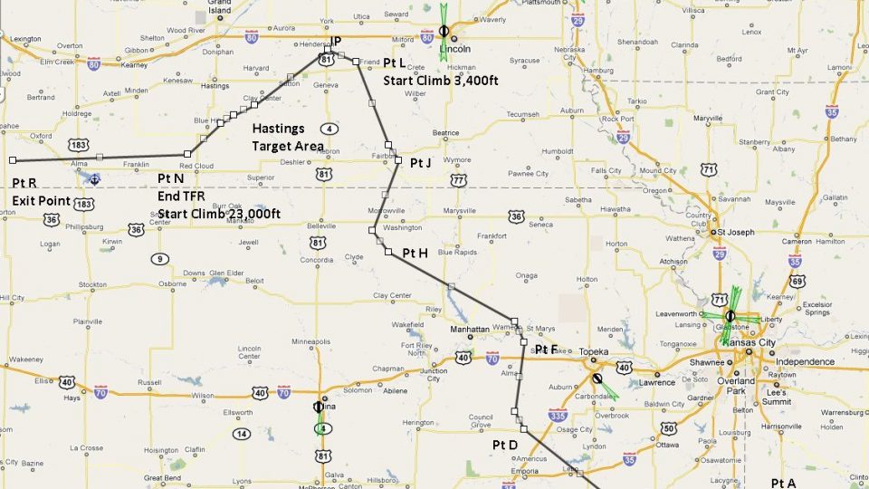
Flight Plan For OB-31 Hastings NE (Old)
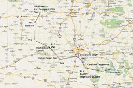
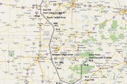
This is the fourteenth in a series of flight plans. This route goes through f…
OB-31 Hastings, Nebraska delivers an IFR high-speed, low-altitude military training flight plan across Midwestern terrain, ideal for terrain-following practice in bombers or fighters. Built for Microsoft Flight Simulator X, it includes Karol Chlebowski’s Terrain Following Radar and Pave Tack gauges, with an optional Mini Panel for streamlined low-level navigation and targeting.
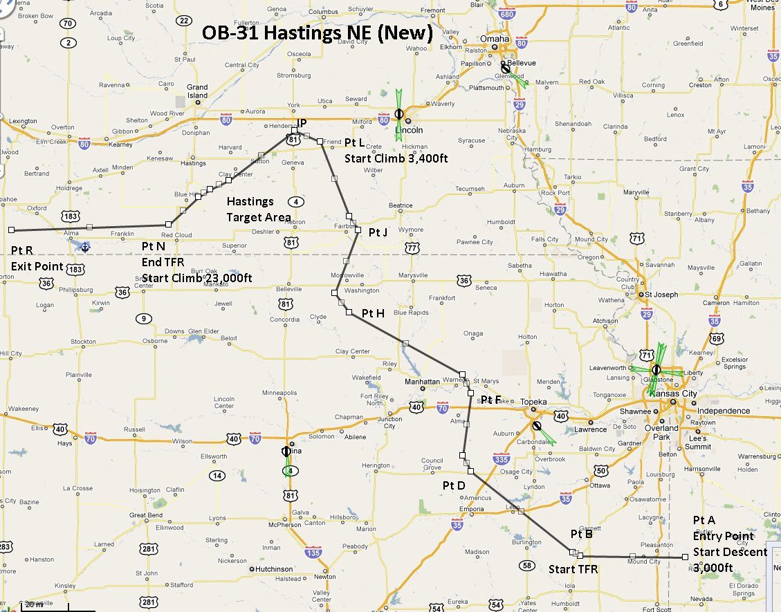
This package provides a detailed, free flight plan designed for the OB-31 Hastings NE IFR high-speed low-altitude military training route. It is the sixth installment in a sequence of files that traverse mostly level Midwestern scenery, passing through Missouri, Kansas, and Nebraska. The included gauges by Karol Chlebowski significantly enhance low-level navigation, and Bill McClellan has meticulously assembled everything to create an immersive experience for virtual bomber and fighter operations.
This particular route operates at swift velocities and minimal altitudes, providing hands-on practice for challenging flights across relatively flat agricultural regions. Since it runs through a vast area of the central United States, pilots can hone their terrain-following techniques while simulating genuine military exercises. Although primarily aimed at Microsoft Flight Simulator X pilots, other platforms can also accommodate this plan with suitable modifications, making it adaptable for diverse simulator setups.
Karol Chlebowski’s TFR gauge (TFR stands for Terrain Following Radar) assists with sustained low-level flight by automatically tracking ground undulations. Its continuous updates provide the information necessary to maintain the safest possible altitude at increased speeds, which is critical for preventing potential collisions with sudden terrain changes.
Another key component is the Pave Tack gauge, which contains sophisticated functionality for reconnaissance, navigation, and strategic bombing runs. Pilots can leverage Pave Tack to precisely identify targets, coordinate approach vectors, and even fine-tune attack methods during more involved missions, adding a realistic dimension to fast jet or bomber flight scenarios.
These flight plans cater to robust bombers and agile fighters alike, making them perfect for models such as the B-52, F-111, B-1B, B-2, A6, A4, and even the Vulcan. However, users may choose any aircraft capability they prefer, tailoring these routes to personal tastes or test scenarios. The low-level environment demands heightened awareness and deft control inputs, accurately replicating the complexities of real-world maneuvers.
A recommended addition is the Mini Panel v2.1. It consolidates critical instrumentation—like TFR readouts and weapon-control systems—into one convenient layout, making the cockpit cleaner and quicker to interpret at high speeds. Many of the specialized functions contained within Karol Chlebowski’s systems are integrated here so that pilots can focus on the intensity of the route without regularly switching screen views.
Overview of flight plans.
This meticulously orchestrated flight plan was devised by Bill McClellan, whose passion for realistic routes has culminated in a compelling carrier for advanced tactical flying. The specialized gauges that complement these training exercises come courtesy of Karol Chlebowski, who has integrated robust features to elevate navigational and targeting authenticity. Together, they deliver an add-on that stands out for those looking to master low-level sorties over the heartland regions of the United States.
Free for all simmers · 936.13 KB · Scanned clean
Download speed: Free tier is capped at 0.5 Mbps. PRO members download at full line speed.
FSX\Missions\ as a sub-folder. The folder must contain an XML file describing the mission.readme.txt or README file. It tells you exactly where files go, what dependencies are needed, and any quirks specific to this add-on.The archive ob-31_hastings_ne_new.zip has 15 files and directories contained within it.
This list displays the first 500 files in the package. If the package has more, you will need to download it to view them.
| Filename/Directory | File Date | File Size |
|---|---|---|
| Approaching IP OB-31 Hastings (new).FLT | 07.09.11 | 20.93 kB |
| Approaching IP OB-31 Hastings (new).FSSAVE | 07.09.11 | 116.50 kB |
| Approaching IP OB-31 Hastings (new).WX | 07.09.11 | 316.74 kB |
| Entering OB-31 Hastings NE (New).FLT | 07.09.11 | 19.04 kB |
| Entering OB-31 Hastings NE (New).FSSAVE | 07.09.11 | 79.80 kB |
| Entering OB-31 Hastings NE (New).WX | 07.09.11 | 316.44 kB |
| OB-31 Hastings NE (New).pln | 07.09.11 | 3.34 kB |
| OB-31 Hastings NE New.jpg | 07.09.11 | 348.46 kB |
| OB-31Target Area .bgl | 07.02.11 | 10.92 kB |
| Pave Tack Notes.doc | 06.16.11 | 327.50 kB |
| Pave Tack.cab | 07.05.11 | 633.89 kB |
| Read Me.txt | 07.09.11 | 12.28 kB |
| TFR.cab | 07.02.11 | 9.88 kB |
| flyawaysimulation.txt | 10.29.13 | 959 B |
| Go to Fly Away Simulation.url | 01.22.16 | 52 B |
More FSX & P3D add-ons hand-picked based on this download.
FSX Misc
This is the fourteenth in a series of flight plans. This route goes through f…
 FSX Misc
Experience a carefully planned IFR high-speed, low-level military training fl…
 FSX Misc
This freeware release introduces a detailed IFR high-speed, low-level militar…
 FSX Misc
This new freeware package provides a carefully crafted IFR (Instrument Flight…
 FSX Misc
This freeware add-on delivers a meticulously crafted IFR, high-speed, low-lev…
 FSX Misc
This carefully designed flight plan offers an immersive low-level, high-speed…
 FSX Misc
This comprehensive package offers a meticulously designed IFR high-speed, low…
 FSX Misc
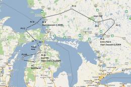
Flight plan for OB-27 Ashland ME and Fort Drum NY IFR high speed low altitude…
Be the first to leave a comment on this download.
Be the first to share your thoughts on this download.