 FSX Scenery
Barakoma Airfield 1943
Scenery Barakoma Airfield 1943, Isle of Vella Lavella, USMC Solomons. By Weyg…
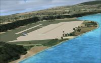
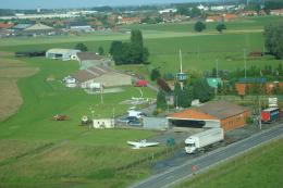
Barakoma Airstrip on Vella Lavella in the Solomon Islands brings a thoughtfully refreshed WWII-era field to life, honoring VMF-214 with richer ground objects, improved layout, and an added taxi strip. Designed for Microsoft Flight Simulator X, the scenery places the strip close to its historic footprint for more immersive island operations.
Scenery Barakoma Airstrip Update. In memory of the Black Sheep Squadron VMF 214, here's the Barakoma Airstrip in the Isle of Vella Lavella in the Solomon Islands. The airstrip is no longer in use. Adds more objects as well as a taxi strip. The airstrip is more or less situated where the original Barakoma airstrip was. By Weygantt Kurt.
Barakoma Airstrip Update Scenery.
This is an update for the Barakoma Airstrip.
In memory of the Black Sheep Squadron VMF 214 here's the Barakoma Airstrip in the Isle of Vella Lavella in the Solomon Islands. The airstrip is no longer in use nowadays.
I've added more objects as well as a Taxi strip.
The airstrip is more or less situated where the original Barakoma airstrip is.
Just delete the existing "VEV_ADEX_KW.BGL" file and replace with the 2 files included.
Here's the path where to drop both airfield bgl files :
C:\Program Files\Microsoft Games\Microsoft Flight Simulator X\Addon Scenery\scenery.
Have fun.
Created by Weygantt Kurt
Free for all simmers · 3 MB · Scanned clean Aug 2026
Download speed: Free tier is capped at 0.5 Mbps. PRO members download at full line speed.
FSX\Addon Scenery\ containing scenery and texture sub-folders.readme.txt or README file. It tells you exactly where files go, what dependencies are needed, and any quirks specific to this add-on.Use these coordinates to fly directly to this location once the mod is installed.
-7.83330000,156.70000000
Launch FSX or Prepar3D and use Flights → Load to open the downloaded .pln file. Your aircraft will be positioned at this location.
The archive fsx_scenery_update_barakoma_airfield_solomons_vmf214.zip has 6 files and directories contained within it.
This list displays the first 500 files in the package. If the package has more, you will need to download it to view them.
| Filename/Directory | File Date | File Size |
|---|---|---|
| VEV_ADEX_KW_CVX.bgl | 01.17.10 | 389 B |
| VEV_ADEX_KW.BGL | 01.17.10 | 1.88 kB |
| readme.txt | 01.17.10 | 642 B |
| barakoma.jpg | 01.17.10 | 6.73 MB |
| flyawaysimulation.txt | 10.29.13 | 959 B |
| Go to Fly Away Simulation.url | 01.22.16 | 52 B |
Only PRO members can place votes.
More FSX & P3D add-ons hand-picked based on this download.
FSX Scenery
Scenery Barakoma Airfield 1943, Isle of Vella Lavella, USMC Solomons. By Weyg…
 FSX Scenery
Scenery Banff National Park Airstrip (CYBA), Canada. Runway moved to correct …
 FSX Scenery
(AX78), South Africa. Robben Island is an island in Table Bay, some seven kil…
 FSX Scenery
Sulphur Creek Ranch AIrstrIp, Idaho (ID). MountaIn prIvate aIrstrIp In Idaho.…
FSX Scenery
A small airstrip in l'Enclave des Papes, south of France between a vineyard a…
 FSX Scenery
Scenery Moorsele Airstrip (EBMO), a grass airstrip in West Flanders, Belgium.…
 FSX Scenery
Cyclone Airstrip In Israel. Cyclone airstrip is an airstrip owned by Cyclone …
FSX Scenery
Metzada (Masada) Airstrip (LLMZ). Masada Airstrip which located near Masada N…
Read what other simmers think, or add your own.
Glad you enjoy it... Had to do some research to find the exact location, went on from old photographs to put the runway in place, and so on... Flown multiple times out of it with a Corsair...
Hey, thanks for building and offering this base on Vella Lavella. I have always been a fan of the Baa Baa Black Sheep series replayed on the History Channel decades ago. I watched every episode as many times as they aired it. Read 3 books on Pappy and the 214, another book on the AVG. Now we have the 214 base on the island, the tents, and the Sheep's pen.
After downloading the base I tried the milk run in a DC3 from Vella to Espirito. No GPS, no VOR or NDB, just a map and compass across 4 hours of nothing but blue ocean. I turned out to miss Espiritos by 63 nmi but got close enough to see it in the distance and turn towards it. The area covered was the size of a quarter on the map I had and maybe I could have gotten closer with a bigger map and could make better measurements. It makes one appreciate the navigational skills they had back then and how much the cost of error was.