FSX Airports and Navaids in Google Earth

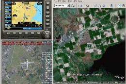
This zip contains all the airports & navaids for Flight Simulator X and includes all comm and nav frequencies, runway details along with any relevant ILS information. Extracted from the default FSX BGL scenery files in Nov 2006. By Ian Niblo.

Download hits
16.7K
Compatibility
Microsoft Flight Simulator X (FSX) including Steam Edition & Prepar3D (P3D)
Filename
fsxge.zip
File size
2.36 MB
Virus Scan
Scanned 20 days ago (clean)
Access to file
Free (Freeware)
Content Rating
Everyone
5 star rating.

Rated 5 out of 5 stars by 16 PRO members.

This zip contains all the airports & navaids for Flight Simulator X and includes all comm and nav frequencies, runway details along with any relevant ILS information. Extracted from the default FSX BGL scenery files in Nov 2006. By Ian Niblo.

The archive fsxge.zip has 9 files and directories contained within it.

File Contents

This list displays the first 500 files in the package. If the package has more, you will need to download it to view them.

Filename/Directory File Date File Size
fsxge.gif11.16.068.34 kB
airport.png08.22.062.74 kB
fsxge.kml11.16.0625.04 MB
ndb.png08.22.062.34 kB
readme.txt11.16.06764 B
vor.png08.22.062.19 kB
FILE_ID.DIZ11.16.06291 B
flyawaysimulation.txt10.29.13959 B
Go to Fly Away Simulation.url01.22.1652 B

Editorial

Having been someone with a keen interest for travelling to new places for many years, I found the relatively recent addition of the internet something that has helped my travel capacity unbelievably. It makes an incredibly big difference to how I get booked up, and now with the help of things like Google Earth I can get a more or less instant set of knowledge about where I need to be and how I can possibly get there in time.

Preview screenshot

This kind of feature makes a big difference to the overall composition and growth of my abilities as a traveler, but tools such as Google Earth are fairly limited in what they let you see. For more help in actually getting the full bang that you could get from using Google Earth, you need to look at some of the awesome modifications that have been made for use with it.

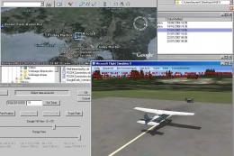
For example, this brilliant project here will give you all the help that you could possibly need in making things work out just the way that you had originally intended. By combining Google Earth with FSX you can now get access to all of the comm and nav frequencies from FSX, as well as various ILS information that might be deemed relevant by the simulator. As you can imagine, this plays a big role in helping make the whole thing seem a whole lot more immersive. What is even more impressive, though, is the way that it contains all of the navigational aids as well as the airports for FSX, adding them into Google Earth for another layer of awesomeness.

It’s a mod that I really do love using for the traveller in me, as well as the FSX fan, meaning that I can get a nice blend of information, facts and figures at all times to help me plan my journeys and my flights better than ever. This allows you to start exploring parts of the world you intend to visit or will have never had the time to visit allowing you to get a full glimpse of just how diverse parts of the world can be. it might seem like a bit of a simplistic addition but when you start getting used to its various changes you will quickly start to see the benefits of having a software package like this installed, helping you really learn geography.

Now, you’ll be able to pinpoint where airports are all across the world and ensure that you have no issues getting to understand the locations and distances of key locations that you wish to visit. The most important aspect of this, though, is the fact that it allows you to start planning and preparing your flights and your missions for FSX with impunities ease; looking for a way to start making FSX a bit easier to handle, a bit more accessible? Then this can be the way to go. I personally love software like this, as it makes everything simpler!

Adam McEnroe

Adam McEnroe

Adam McEnroe is a flight sim enthusiast who has been simming since the days of FS95. Adam writes all of the download section editorials after testing each of the files. Adam has extensive knowledge using various flight simulator packages and thoroughly tests the files before writing about them. Adam also like to fly real-world aircraft in his spare time and is training for his PPL.

Should you wish, you can contact Adam via email at adam@flyawaysimulation.com.

Installation icon.

Installation Instructions

Most of the freeware add-on aircraft and scenery packages in our file library come with easy installation instructions which you can read above in the file description. For further installation help, please see our Flight School for our full range of tutorials or view the README file contained within the download. If in doubt, you may also ask a question or view existing answers in our dedicated Q&A forum.

11 comments

Leave a Response

The content of the comments below are entirely the opinions of the individual posting the comment and do not always reflect the views of Fly Away Simulation. We moderate all comments manually before they are approved.

AHARON HAR EVENSat, 09 Jun 2012 08:55:39 GMT

Great tool, makes you feel so near to the real world, usefull tool!

jwblackThu, 05 Aug 2010 04:21:33 GMT
Extremely useful, great for exploring places you have never been, just make sure to check only the area you want and zoom in or else you'll have dots all over the place. Great for inventing your own adventures.
jewkid80Sun, 25 May 2008 16:28:25 GMT
10/10 awesome
skyewalkerSun, 16 Mar 2008 17:21:07 GMT
Great to see exactly where all the worlds airports are. I set google earth up on laptop besides my FSX computer and wow you can plan flights and missions with ease. Tks
boxy59Sun, 16 Mar 2008 09:12:51 GMT
great
96EyesSat, 17 Feb 2007 20:55:26 GMT
One of the most useful downloads, makes it a-piece-of-cake to explore unfamilliar areas of the world. Extremely handy with the ability, for instance, to turn off VORs and NDBs and leave just the airports to scan through (by unchecking the proper boxes in Google Earth--something that a guy above didn't notice or discover). Keep up the good work! (I was actually wishing that someone would have done something like this!)
littlejoeFri, 19 Jan 2007 01:01:55 GMT
This is a geart addon really useful!
viewjewThu, 04 Jan 2007 02:39:21 GMT
Great job Ian !!
EnsPulverThu, 28 Dec 2006 00:06:27 GMT
Works well and does what it is supposed to. Zoom in to a pretty small area or it takes forever to populate the world with vor's, etc.
daniel_spitznerMon, 27 Nov 2006 17:16:40 GMT
Fully agree. World pilots should have something like this. It works very good. Gives much information about real frequencies and much more. 10/10.
bennelliottFri, 24 Nov 2006 19:00:20 GMT
Great Idea, very useful, even for real world pilots.

Leave a comment