 FSX Scenery
Saratoga County Airport 5B2 Fix
Saratoga County Airport, New York (NY) v2.0 ADE fix. Reworked ADE file to fix…
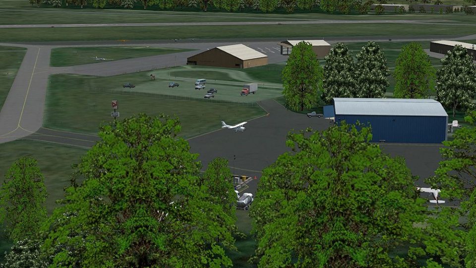
Saratoga County Airport (5B2) v2 recreates the upstate New York general aviation field near Saratoga Springs with fully rebuilt Gmax structures, high-resolution photoreal ground imagery, and a corrected perimeter for a more faithful layout in FSX Acceleration. Custom taxiways, taxi signs, 3D taxi lights, seasonal texture options, and an updated ADEX file support smooth GA AI traffic.


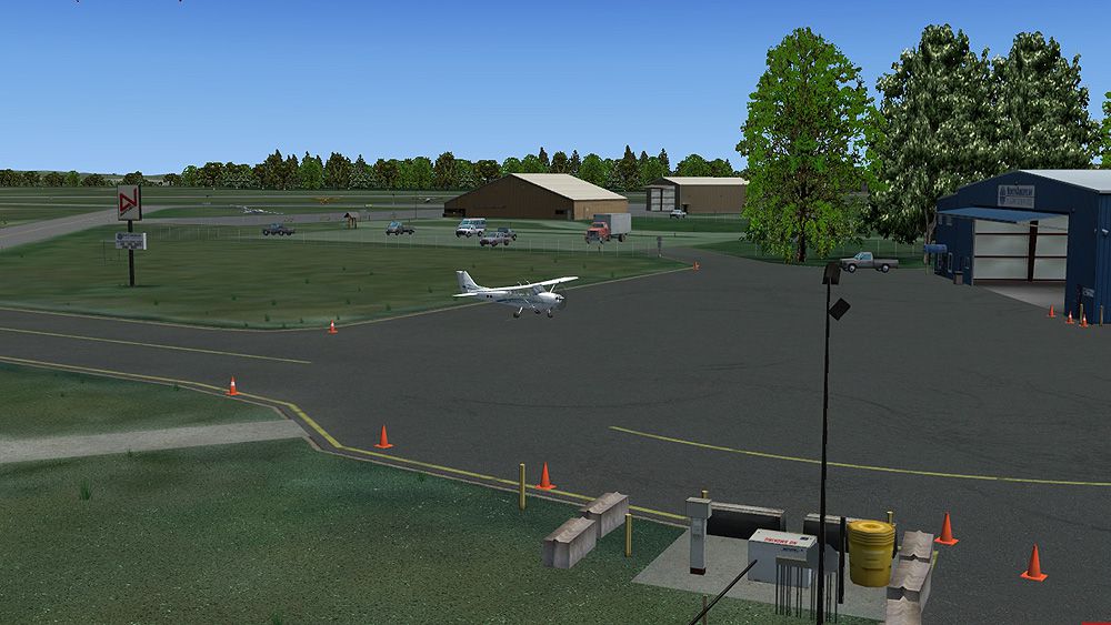
Saratoga County Airport, New York (5B2) v2.0 for FSX Acceleration. Located in the foothills of the Adirondack Mountains in upstate NY, USA. This facility is owned by Saratoga County, formerly housed Rich Air and currently houses North American Aviation. 5B2 is a non-controlled airfield catering to small engine aircraft up to a few private jets, with daily traffic serving 'The Northcountry' and Saratoga Springs, New York. All objects fully designed and completely redone in Gmax using high resolution photoreal textures. Optional seasonal files included. Also includes new ADEX file, more accurate airport grounds perimeter, satellite photoreal grounds, custom taxiways, taxi-signs and taxi lights. ADEX file also designed to support general aviation AI. All textures mipmapped for performance. By Ed Cox. (See also 5B2_X_FIX.ZIP).
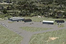
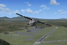
Screenshot of Saratoga County Airport scenery.
Saratoga County Airport (5B2), w/ all custom photoreal buildings, ground textures, field signs, and plaza buildings. With 3D taxilights, custom runway signs, and new ADE file, Airport re-designed from the ground up. Satelite Ground Textures change with the winter. Entire airport constructed in GMAX...
(Taken from Wikipedia)
Saratoga County Airport (FAA LID: 5B2) is a county-owned public-use airport located three miles (5 km) southwest of the central business district of Saratoga Springs, a city in Saratoga County, New York, United States. This general aviation airport serves the city of Saratoga Springs and surrounding areas.
Saratoga County Airport covers an area of 300 acres (120 ha) which contains two* runways: 5/23 measuring 4,700 x 100 ft (1,433 x 30 m) and 14/32 measuring 4,000 x 100 ft (1,219 x 30 m). Jet aircraft use runways 5 or 23.
For the 12-month period ending August 28, 2008, the airport had 38,700 aircraft operations, an average of 106 per day: 57% local general aviation, 39% transient general aviation, 4% air taxi and <1% military. At that time there were 54 aircraft based at this airport: 34 single-engine, 3 multi-engine, 16 gliders and 1 jet.
* - changed to 2, from original Wiki incorrect semantic post of four.
Free for all simmers · 24.26 MB · Scanned clean Jul 2026
Download speed: Free tier is capped at 0.5 Mbps (this file takes approximately 7 mins at the cap). PRO members download at full line speed.
This add-on may require the following files to function properly. If this is a repaint, the dependency below is likely the base aircraft package.
FSX\Addon Scenery\ containing scenery and texture sub-folders.readme.txt or README file. It tells you exactly where files go, what dependencies are needed, and any quirks specific to this add-on.Use these coordinates to fly directly to this location once the mod is installed.
43.05070000,-73.86160000
Launch FSX or Prepar3D and use Flights → Load to open the downloaded .pln file. Your aircraft will be positioned at this location.
The archive 5b2_x_v2.zip has 197 files and directories contained within it.
This list displays the first 500 files in the package. If the package has more, you will need to download it to view them.
| Filename/Directory | File Date | File Size |
|---|---|---|
| 5B2_v2_FSX | 05.02.12 | 0 B |
| 5B2_X_v2_thumb.gif | 05.02.12 | 10.14 kB |
| Addon Scenery | 05.02.12 | 0 B |
| 5B2_X_Gnd | 05.02.12 | 0 B |
| Scenery | 05.02.12 | 0 B |
| CVX_5B2_-_X.BGL | 04.29.12 | 381 B |
| 5B2_X_Obj | 05.02.12 | 0 B |
| Scenery | 05.02.12 | 0 B |
| 5B2_01.bgl | 08.06.11 | 355 B |
| 5B2_ADEX_ERC.BGL | 05.01.12 | 12.19 kB |
| 5B2_ADEX_ERC_OBJ.BGL | 05.01.12 | 157.14 kB |
| 5B2_X_Lib01.bgl | 04.22.12 | 350.00 kB |
| 5B2_X_Lib02.bgl | 03.28.12 | 59.88 kB |
| GPX_04_01.bgl | 04.27.12 | 26.86 kB |
| GPX_08_01.bgl | 03.21.12 | 12.44 kB |
| GPX_12_01.bgl | 03.21.12 | 8.88 kB |
| GPX_16_01.bgl | 03.21.12 | 42.67 kB |
| GPX_20_01.bgl | 03.21.12 | 22.50 kB |
| GPX_24_01.bgl | 03.21.12 | 3.56 kB |
| GPX_28_01.bgl | 03.21.12 | 46.56 kB |
| GPX_32_01.bgl | 03.21.12 | 3.46 kB |
| Texture | 05.02.12 | 0 B |
| A1.dds | 03.19.12 | 341.45 kB |
| A1w.dds | 03.19.12 | 341.45 kB |
| A1w_lm.dds | 03.19.12 | 341.45 kB |
| A1_lm.dds | 03.19.12 | 341.45 kB |
| A2.dds | 03.19.12 | 341.45 kB |
| A2w.dds | 03.19.12 | 341.45 kB |
| A2w_lm.dds | 03.19.12 | 341.45 kB |
| A2_lm.dds | 03.19.12 | 341.45 kB |
| A3.dds | 03.19.12 | 341.45 kB |
| A3w.dds | 03.19.12 | 341.45 kB |
| A3w_lm.dds | 03.19.12 | 341.45 kB |
| A3_lm.dds | 03.19.12 | 341.45 kB |
| Antennas_1.dds | 03.22.12 | 341.45 kB |
| Antennas_1_lm.dds | 03.22.12 | 341.45 kB |
| B1.dds | 03.19.12 | 341.45 kB |
| B1w.dds | 03.19.12 | 341.45 kB |
| B1w_lm.dds | 03.19.12 | 341.45 kB |
| B1_lm.dds | 03.19.12 | 341.45 kB |
| B2.dds | 03.19.12 | 341.45 kB |
| B2w.dds | 03.19.12 | 341.45 kB |
| B2w_lm.dds | 03.19.12 | 341.45 kB |
| B2_lm.dds | 03.19.12 | 341.45 kB |
| B3.dds | 03.19.12 | 341.45 kB |
| B3w.dds | 03.19.12 | 341.45 kB |
| B3w_lm.dds | 03.19.12 | 341.45 kB |
| B3_lm.dds | 03.19.12 | 341.45 kB |
| Barrel_Y_01.dds | 03.22.12 | 42.78 kB |
| Barrel_Y_01_lm.dds | 03.22.12 | 42.78 kB |
| Beams_01.dds | 03.18.12 | 42.79 kB |
| BEAMS_01_LM.dds | 03.18.12 | 42.79 kB |
| Bldngs_01.dds | 03.25.12 | 1.33 MB |
| Bldngs_01_lm.dds | 03.25.12 | 1.33 MB |
| Bldngs_02.dds | 03.22.12 | 1.33 MB |
| Bldngs_02_lm.dds | 03.22.12 | 1.33 MB |
| Bldngs_03.dds | 03.18.12 | 682.79 kB |
| BLDNGS_03_LM.dds | 03.18.12 | 682.79 kB |
| Bldngs_04.dds | 03.18.12 | 682.79 kB |
| BLDNGS_04_LM.dds | 03.18.12 | 682.79 kB |
| Bldngs_05.dds | 03.22.12 | 1.33 MB |
| Bldngs_05_lm.dds | 03.22.12 | 1.33 MB |
| C1.dds | 03.19.12 | 341.45 kB |
| C1w.dds | 03.19.12 | 341.45 kB |
| C1w_lm.dds | 03.19.12 | 341.45 kB |
| C1_lm.dds | 03.19.12 | 341.45 kB |
| C2.dds | 03.19.12 | 341.45 kB |
| C2w.dds | 03.19.12 | 341.45 kB |
| C2w_lm.dds | 03.19.12 | 341.45 kB |
| C2_lm.dds | 03.19.12 | 341.45 kB |
| C3.dds | 03.19.12 | 341.45 kB |
| C3w.dds | 03.19.12 | 341.45 kB |
| C3w_lm.dds | 03.19.12 | 341.45 kB |
| C3_lm.dds | 03.19.12 | 341.45 kB |
| Concrete_01.dds | 03.19.12 | 341.45 kB |
| Concrete_01_lm.dds | 03.19.12 | 341.45 kB |
| Cone_01.dds | 03.22.12 | 21.45 kB |
| Cone_01_lm.dds | 03.22.12 | 21.45 kB |
| Cone_02.dds | 03.25.12 | 21.45 kB |
| Cone_02_lm.dds | 03.25.12 | 21.45 kB |
| Container_01.dds | 04.01.12 | 170.78 kB |
| Container_01_lm.dds | 04.01.12 | 170.78 kB |
| D1.dds | 03.19.12 | 85.45 kB |
| D1w.dds | 03.19.12 | 85.45 kB |
| D1w_lm.dds | 03.19.12 | 85.45 kB |
| D1_lm.dds | 03.19.12 | 85.45 kB |
| D2.dds | 03.19.12 | 85.45 kB |
| D2w.dds | 03.19.12 | 85.45 kB |
| D2w_lm.dds | 03.19.12 | 85.45 kB |
| D2_lm.dds | 03.19.12 | 85.45 kB |
| FuelPipes_01.dds | 03.22.12 | 85.45 kB |
| FuelPipes_01_lm.dds | 03.22.12 | 85.45 kB |
| FuelTanks_01.dds | 03.22.12 | 170.78 kB |
| FuelTanks_01_lm.dds | 03.22.12 | 170.78 kB |
| FuelTanks_02.dds | 03.22.12 | 170.78 kB |
| FuelTanks_02_lm.dds | 03.22.12 | 170.78 kB |
| FuelTanks_03.dds | 03.22.12 | 170.78 kB |
| FuelTanks_03_lm.dds | 03.22.12 | 170.78 kB |
| Grainer_01.dds | 03.19.12 | 341.45 kB |
| Grainer_01_lm.dds | 03.19.12 | 341.45 kB |
| Grass_01.dds | 04.05.12 | 85.44 kB |
| Grass_01_lm.dds | 04.05.12 | 85.44 kB |
| Hangar_Floor_01.dds | 03.19.12 | 341.45 kB |
| Hangar_Floor_01_lm.dds | 03.25.12 | 341.45 kB |
| HgrIns_01.dds | 03.18.12 | 170.79 kB |
| HGRINS_01_LM.dds | 03.18.12 | 170.79 kB |
| Ovrun_01.dds | 03.19.12 | 1.33 MB |
| Ovrun_01_lm.dds | 03.19.12 | 1.33 MB |
| Pipes_01.dds | 03.25.12 | 42.75 kB |
| Pipes_01_lm.dds | 03.25.12 | 42.75 kB |
| Plaza_01.dds | 03.25.12 | 1.33 MB |
| Plaza_01_lm.dds | 03.25.12 | 1.33 MB |
| Post_Conc_01.dds | 03.25.12 | 21.45 kB |
| Post_Conc_01_lm.dds | 03.25.12 | 21.45 kB |
| Roof_Tiler_01.dds | 03.25.12 | 42.78 kB |
| Roof_Tiler_01_lm.dds | 03.25.12 | 42.78 kB |
| Roof_Tiler_02.dds | 03.18.12 | 42.79 kB |
| ROOF_TILER_02_LM.dds | 03.18.12 | 42.79 kB |
| Roof_Tiler_03.dds | 03.18.12 | 42.79 kB |
| ROOF_TILER_03_LM.dds | 03.18.12 | 42.79 kB |
| Roof_Tiler_04.dds | 03.26.12 | 85.45 kB |
| Roof_Tiler_04_lm.dds | 03.26.12 | 85.45 kB |
| Runway_Overlay_01.dds | 03.19.12 | 1.33 MB |
| Runway_Overlay_01_lm.dds | 03.19.12 | 1.33 MB |
| Rwy_Base_01.dds | 03.19.12 | 1.33 MB |
| Rwy_Base_01_lm.dds | 03.19.12 | 1.33 MB |
| Rwy_Edge_01.dds | 03.19.12 | 42.62 kB |
| Rwy_Edge_01_lm.dds | 03.19.12 | 42.62 kB |
| Rwy_Edge_02.dds | 03.19.12 | 21.12 kB |
| Rwy_Edge_02_lm.dds | 03.19.12 | 21.12 kB |
| Rwy_Markings_01.dds | 03.19.12 | 1.33 MB |
| Rwy_Markings_01_lm.dds | 03.19.12 | 1.33 MB |
| Rwy_Markings_02.dds | 03.19.12 | 10.62 kB |
| Rwy_Markings_02_lm.dds | 03.19.12 | 10.62 kB |
| Signs_01.dds | 03.22.12 | 1.33 MB |
| Signs_01_lm.dds | 03.22.12 | 1.33 MB |
| Taxilight_01.dds | 03.26.12 | 85.45 kB |
| Taxilight_01_lm.dds | 03.26.12 | 85.45 kB |
| TaxiLine_01.dds | 03.19.12 | 21.12 kB |
| TaxiLine_01_lm.dds | 03.19.12 | 21.12 kB |
| TaxiLine_02.dds | 03.19.12 | 42.75 kB |
| TaxiLine_02_lm.dds | 03.19.12 | 42.75 kB |
| TaxiLine_03.dds | 03.19.12 | 21.12 kB |
| TaxiLine_03_lm.dds | 03.19.12 | 21.12 kB |
| TaxiwaySigns_01.dds | 03.22.12 | 682.78 kB |
| TaxiwaySigns_01_lm.dds | 03.22.12 | 682.78 kB |
| Taxi_Base_01.dds | 03.19.12 | 1.33 MB |
| Taxi_Base_01_lm.dds | 03.19.12 | 1.33 MB |
| Taxi_Base_02.dds | 03.19.12 | 1.33 MB |
| Taxi_Base_02_lm.dds | 03.19.12 | 1.33 MB |
| Tire_Marks_01.dds | 03.19.12 | 341.44 kB |
| Tire_Marks_01_lm.dds | 03.19.12 | 341.44 kB |
| Tire_Marks_02.dds | 03.19.12 | 341.45 kB |
| Tire_Marks_02_lm.dds | 03.19.12 | 341.45 kB |
| Ts_Tiedowns_01.dds | 03.19.12 | 341.45 kB |
| Ts_Tiedowns_01_lm.dds | 03.19.12 | 341.45 kB |
| Txwy_Edger_01.dds | 03.19.12 | 21.38 kB |
| Txwy_Edger_01_lm.dds | 03.19.12 | 21.38 kB |
| Txwy_Edger_02.dds | 03.19.12 | 21.38 kB |
| Txwy_Edger_02_lm.dds | 03.19.12 | 21.38 kB |
| Vehicles_GS_01.dds | 04.12.12 | 341.45 kB |
| Vehicles_GS_01_lm.dds | 04.12.12 | 341.45 kB |
| windsock.bmp | 07.27.10 | 85.43 kB |
| windsock_lm.bmp | 07.27.10 | 85.43 kB |
| Effects | 04.08.12 | 0 B |
| GS_ObsLight_01.fx | 04.08.12 | 2.49 kB |
| GS_RedLight_01.fx | 04.08.12 | 1.33 kB |
| GS_Taxilight_01.fx | 04.08.12 | 1.26 kB |
| texture | 04.03.12 | 0 B |
| fx_2_GS.bmp | 04.02.12 | 341.40 kB |
| file.diz | 05.02.12 | 836 B |
| ReadMe.txt | 05.02.12 | 6.58 kB |
| Screenshots | 05.02.12 | 0 B |
| ScreenShot017.jpg | 05.02.12 | 231.89 kB |
| ScreenShot018.jpg | 05.02.12 | 251.21 kB |
| ScreenShot019.jpg | 05.02.12 | 348.04 kB |
| Seasonal_Objects | 05.01.12 | 0 B |
| Grass | 05.01.12 | 0 B |
| Summer_Grass | 05.01.12 | 0 B |
| Grass_01.dds | 04.05.12 | 85.44 kB |
| Grass_01_lm.dds | 04.05.12 | 85.44 kB |
| Winter_Grass | 05.02.12 | 0 B |
| Grass_01.dds | 05.02.12 | 85.44 kB |
| Grass_01_lm.dds | 05.02.12 | 85.44 kB |
| Trees | 05.02.12 | 0 B |
| Fall | 05.01.12 | 0 B |
| 5B2_ADEX_ERC_OBJ.BGL | 05.01.12 | 157.14 kB |
| HardWinter | 05.02.12 | 0 B |
| 5B2_ADEX_ERC_OBJ.BGL | 05.02.12 | 157.14 kB |
| Spring | 05.01.12 | 0 B |
| 5B2_ADEX_ERC_OBJ.BGL | 05.01.12 | 157.14 kB |
| Summer | 05.01.12 | 0 B |
| 5B2_ADEX_ERC_OBJ.BGL | 05.01.12 | 157.14 kB |
| Winter | 05.01.12 | 0 B |
| 5B2_ADEX_ERC_OBJ.BGL | 05.01.12 | 157.14 kB |
| flyawaysimulation.txt | 10.29.13 | 959 B |
| Go to Fly Away Simulation.url | 01.22.16 | 52 B |
Only PRO members can place votes.
More FSX & P3D add-ons hand-picked based on this download.
FSX Scenery
Saratoga County Airport, New York (NY) v2.0 ADE fix. Reworked ADE file to fix…
 FSX Scenery
Saratoga County Airport (5B2), Saratoga Springs, New York (NY). Features corr…
 FSX Scenery
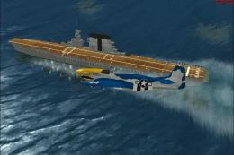
USS Saratoga CV-3. This is a true FSX scenery object compiled with Xtomdl. It…
 FSX Scenery
USS Saratoga. This is a tweak of Paul Clawson's Saratoga static scenery add-o…
 FSX Scenery
Aspen-Pitkin County Airport Scenery (KASE), Colorado (CO). This scenery adds …
 FSX Scenery
Westchester County Airport (KPHN), White Plains, New York (NY). An improved v…
 FSX Scenery
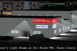
Essex County Airport NJ (IATA: CDW, ICAO: KCDW, FAA LID: CDW) is a public air…
 FSX Scenery
Charles M. Schulz - Sonoma County Airport (KSTS), Santa Rosa, California (CA)…
Be the first to leave a comment on this download.
Be the first to share your thoughts on this download.