
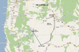
FSX Flight Plan For OB-96 Fort Worth Texas
OB-96 delivers a high-speed, low-altitude IFR military training route around Fort Worth, spanning Texas, Oklahoma, and Louisiana with clear checkpoints and objective points for strike or reconnaissance practice in Microsoft Flight Simulator X. Optional Terrain Following Radar and Pave Tack-style gauges deepen virtual cockpit navigation and mission workload across bombers and fast jets.

 Prepar3D
- File: ob-96_fort_worth_tx_.zip
- Size:1.07 MB
- Scan:
Clean (11d)
- Access:Freeware
- Content:Everyone
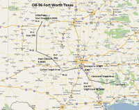
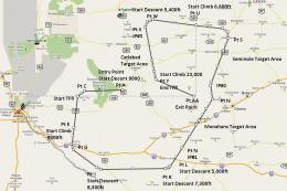
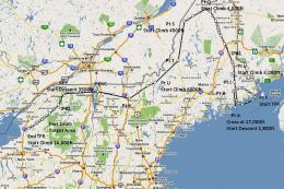
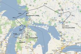
This new freeware package provides a carefully crafted IFR (Instrument Flight Rules) high-speed, low-altitude military training route in the vicinity of Fort Worth, Texas, designated as OB-96. This release is the fifteenth installment in a growing series, and it meticulously spans terrain in Texas, Oklahoma, and Louisiana. Developed by Bill McClellan, it caters to enthusiasts keen on challenging bomber or fighter operations within Microsoft Flight Simulator X. Additionally, it integrates specialized avionics by Karol Chlebowski that significantly enhance low-altitude navigation and mission complexity.
Focused High-Speed Military Route
The OB-96 corridor emphasizes swift tactical maneuvers that expose pilots to multiple types of terrain transitions. Flaunting stretches of both flat and rolling landscapes, the path facilitates proficient low-level flights, especially for crews flying heavy bombers such as the B-52, B-1B, or B-2, and tactical jets like the F-111, A6, A4, or Vulcan. Frequent altitude shifts can be practiced to simulate advanced radar-evading procedures and to maintain terrain awareness at all times.
Diverse Targets and Strategic Checkpoints
This route incorporates two distinct sets of targets (referred to as designated objective points), allowing virtual pilots to practice coordinated strikes or reconnaissance activities. Rolls of gently changing geography further intensify pilot workload, ensuring accurate flight navigation. Furthermore, the route’s layout encourages methodical mission planning to account for altitudes, headings, and potential weather shifts while ensuring each checkpoint is successfully reached.
Enhanced Instruments for TFR Operations
Two optional gauges by Karol Chlebowski come bundled within the package. The first is optimized for TFR (Terrain Following Radar) flying, which provides seamless low-level orientation across rapidly shifting elevations. The second, known as Pave Tack, refines bombing, navigation, and reconnaissance workflows by offering precise sensor data and advanced functionality. With these gauges, complex flight profiles become more accessible, and mission accuracy is substantially improved.
Optional Mini Panel v2.1
For those seeking even more control and added capabilities, reference is made to the mini panel upgraded to version 2.1. It integrates the same advanced gauge functionalities along with an expanded toolkit that streamlines aircraft systems management during critical flight phases. Pilots looking to master low-level routes will likely appreciate the refined instrumentation features found in this enhanced panel.
Compatible Aircraft Choices
Although the OB-96 route is chiefly designed for military bombers and interceptors, any aircraft can be flown to explore the scenic stretch. The developer, Bill McClellan, has ensured that the flight plan is flexible enough for those who prefer other jets or propeller-driven planes. The emphasis remains on immersive navigation, so the journey suits a variety of pilot preferences.
Overview of flight plans.
Credit to the Creators
This comprehensive route and accompanying materials are provided by Bill McClellan, showcasing his dedication to realistic simulation experiences. The specialized gauges for TFR flying and Pave Tack have been crafted by Karol Chlebowski, broadening the scope of potential missions and refining the overall approach to low-altitude operations. Together, they offer a fully immersive military-style training journey that harnesses the capabilities of Microsoft Flight Simulator X.
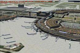
Images & Screenshots
The archive ob-96_fort_worth_tx_.zip has 19 files and directories contained within it.
File Contents
This list displays the first 500 files in the package. If the package has more, you will need to download it to view them.
| Filename/Directory | File Date | File Size |
|---|---|---|
| IP Inbound OB-96 Carbon Texas.FLT | 07.12.11 | 17.18 kB |
| IP Inbound OB-96 Carbon Texas.FSSAVE | 07.12.11 | 101.29 kB |
| IP Inbound OB-96 Carbon Texas.WX | 07.12.11 | 309.74 kB |
| IP Inbound OB-96 Corsicana Texas.FLT | 07.12.11 | 15.67 kB |
| IP Inbound OB-96 Corsicana Texas.FSSAVE | 07.12.11 | 116.15 kB |
| IP Inbound OB-96 Corsicana Texas.WX | 07.12.11 | 322.46 kB |
| OB-96 Fort Worth TX.jpg | 07.12.11 | 418.51 kB |
| OB-96 Fort Worth TX.pln | 07.12.11 | 2.51 kB |
| Pave Tack Notes.doc | 06.16.11 | 327.50 kB |
| Pave Tack.cab | 07.05.11 | 633.89 kB |
| Read Me.txt | 07.12.11 | 13.39 kB |
| Targets OB-96 Carbon TX.BGL | 07.12.11 | 1.01 kB |
| Targets OB-96 Corsicana TX.BGL | 07.12.11 | 957 B |
| TFR.cab | 07.02.11 | 9.88 kB |
| Entering OB-96 Fort Worth TX.FLT | 07.12.11 | 16.86 kB |
| Entering OB-96 Fort Worth TX.FSSAVE | 07.12.11 | 68.01 kB |
| Entering OB-96 Fort Worth TX.WX | 07.12.11 | 315.75 kB |
| flyawaysimulation.txt | 10.29.13 | 959 B |
| Go to Fly Away Simulation.url | 01.22.16 | 52 B |
Installation Instructions
Most of the freeware add-on aircraft and scenery packages in our file library come with easy installation instructions which you can read above in the file description. For further installation help, please see our Flight School for our full range of tutorials or view the README file contained within the download. If in doubt, you may also ask a question or view existing answers in our dedicated Q&A forum.

0 comments
Leave a Response