FSX Parauapebas City - SRTM Meshes Correction Scenery
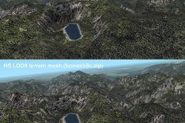
Parauapebas City SRTM mesh correction improves terrain and airport elevation accuracy around Carajás Airport (SBCJ/CKS) in Brazil, delivering a more believable runway profile and surrounding relief for both VFR and IFR flying. Built for Microsoft Flight Simulator X, it refines local altitude data with targeted flattening to smooth ground operations.
 Brazil
 - File: sbcj_cor.zip
- Size:6.09 KB
- Scan:
Clean (27d)

- Access:Freeware
- Content:Everyone

Improve altitude accuracy around Carajás Airport in Parauapebas City, Brazil with this free scenery correction that fine-tunes Shuttle Radar Topography Mission (SRTM) meshes and ensures a more authentic terrain profile. Developed by Cesar Marinho for Microsoft Flight Simulator X, this enhancement addresses elevation discrepancies at SBCJ, offering a refined runway environment and more lifelike surroundings.
Geographic Background and Terrain Specifics
Positioned in a region renowned for large-scale mining activities, Carajás Airport (IATA code: CKS) sits near Parauapebas, which lies in southeastern Pará. The default topography in many simulators can lead to inaccurate elevation data. To rectify this, the add-on adjusts altitudes in critical spots, ensuring that virtual pilots experience terrain relief consistent with reality. By implementing a specialized flatten parameter, the runway maintains correct elevation, which benefits both visual (VFR) and instrument (IFR) approaches.
Key Adjustments and File Details
SBCJ_FLATTEN.BGL
This file handles the flattening process. In flight simulator environments, “flattening” ensures that any irregularities on the airfield’s surface are minimized or removed, enabling authentic taxiway alignment and smoother ground operations. Placing this BGL in the appropriate folder significantly improves Gates, taxi routes, and overall apron accuracy.
APX34340.BGL
Found in the simulator’s “0404” scenery folder, this component ensures that airport-related data aligns with the real-world altitude. The developer has fine-tuned elevation references to sync with official coordinates, thereby reducing unwanted terrain anomalies. It is vital to preserve an original backup of this file in case you need to revert to default data in the future.
Installation Steps
- Backup Existing Data: Locate the APX34340.BGL file in
C:\Program Files\Microsoft Games\Microsoft Flight Simulator X\Scenery\0404\scenery, and create a safe backup copy. - Flatten File Placement: Copy SBCJ_FLATTEN.BGL into
C:\Program Files\Microsoft Games\Microsoft Flight Simulator X\Addon Scenery\scenery, or whichever directory you use for custom mesh installations. - Replacing APX34340.BGL: Copy the revised APX34340.BGL into
C:\Program Files\Microsoft Games\Microsoft Flight Simulator X\Scenery\0404\scenery, making sure the old file is safely stored away.
This configuration applies exclusively to Microsoft Flight Simulator X. Other simulators, such as the more recent Microsoft Flight Simulator or earlier versions like Microsoft Flight Simulator 2004, are not supported by these mesh corrections.
Notes on Usage and Acknowledgments
While this add-on primarily addresses incorrect altitude data, it can also subtly enhance visual immersion around the broader Carajás mining territory. The changes may affect various approach angles and navigation calculations, so it’s advisable to become familiar with altered charts, if any, when planning flights.
All coding and mesh refinements were implemented by Cesar Marinho, who has generously provided this freeware solution for enthusiasts looking to optimize terrain fidelity in the virtual skies of Parauapebas. Enjoy the revamped environment and advanced topographical realism as you come in to land at SBCJ.

Finding the Scenery
- FSX/Prepar3D Coordinates:
-
-6.11820000,-50.00110000
Use the downloaded flight plan file by launching FSX/P3D, selecting "Load Flight Plan" in the flight planner, and choosing the .pln file. Your aircraft will be positioned directly at the add-on’s location. - Decimal Degrees (DD):
-
Latitude: -6.118200°
Longitude: -50.001100° - Degrees, Minutes, Seconds (DMS):
-
Latitude: 6° 07' 05.520" S
Longitude: 50° 00' 03.960" W
Map Location
The archive sbcj_cor.zip has 6 files and directories contained within it.
File Contents
This list displays the first 500 files in the package. If the package has more, you will need to download it to view them.
| Filename/Directory | File Date | File Size |
|---|---|---|
| File_ID.diz | 06.11.07 | 177 B |
| readme.txt | 06.11.07 | 812 B |
| APX34340.BGL | 06.11.07 | 9.31 kB |
| SBCJ_FLATTEN.BGL | 06.11.07 | 283 B |
| flyawaysimulation.txt | 10.29.13 | 959 B |
| Go to Fly Away Simulation.url | 01.22.16 | 52 B |
Installation Instructions
Most of the freeware add-on aircraft and scenery packages in our file library come with easy installation instructions which you can read above in the file description. For further installation help, please see our Flight School for our full range of tutorials or view the README file contained within the download. If in doubt, you may also ask a question or view existing answers in our dedicated Q&A forum.

0 comments
Leave a Response