FSX La Teste De Buch Scenery
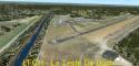
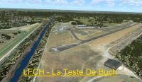
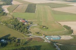
LFCH La Teste-de-Buch scenery refreshes the Arcachon airfield in Aquitaine, France with updated airport layout, terrain shaping, and custom object placement for more authentic VFR arrivals. Designed for FSX and compatible with common regional landclass setups, it delivers a cleaner, more detailed representation of this southwest French commune.

 France
 - File: lfch-latestedebuch.zip
- Size:9.43 MB
- Scan:
Clean (7d)

- Access:Freeware
- Content:Everyone
Scenery La Teste De Buch(LFCH), Arcachon, Aquitaine, France. Tested with SP2 Acceleration + UTX Europe. Thisfile modifies the airfield La Teste De Buchin FSX. It was made with ADE (Airport DesignEditor), SbuilderX and Whisplacer. La TesteDe Buch is a commune in the Landesdepartment in Aquitaine in south-westernFrance. By Stephane Gouzon.
La Teste De Buch Scenery.
Scenery LFCH La Teste De Buch V1.0 for FSX.
Tested with SP2 Acceleration + UTX Europe.
This file modifies the airfield La Teste De Buch in FSX. It was made with ADE (Airport Design Editor), SbuilderX and Whisplacer.
Thank you to the respective authors and Patrick Renaudin for its objects.
La Teste-de-Buch is a commune in the Landes department in Aquitaine in south-western France.
Installation:
- Unzip the archive into a temporary folder.
- Copy the folder "LFCH - La Teste De Buch" in the addon scenery folder of FSX.
- Delete the temporary folder.
- Start FSX.
- Add and declare the scene in the FSX scenery library.
This file is a freeware.
Author: Stéphane Gouzon
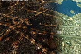
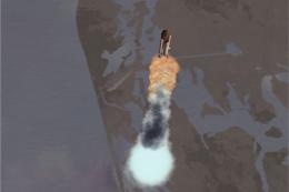
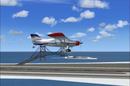
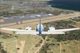
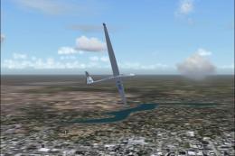
Images & Screenshots

Finding the Scenery
- FSX/Prepar3D Coordinates:
-
44.59390000,-1.11080000
Use the downloaded flight plan file by launching FSX/P3D, selecting "Load Flight Plan" in the flight planner, and choosing the .pln file. Your aircraft will be positioned directly at the add-on’s location. - Decimal Degrees (DD):
-
Latitude: 44.593900°
Longitude: -1.110800° - Degrees, Minutes, Seconds (DMS):
-
Latitude: 44° 35' 38.040" N
Longitude: 1° 06' 38.880" W
Map Location
The archive lfch-latestedebuch.zip has 19 files and directories contained within it.
File Contents
This list displays the first 500 files in the package. If the package has more, you will need to download it to view them.
| Filename/Directory | File Date | File Size |
|---|---|---|
| LFCH - La Teste De Buch | 05.28.10 | 0 B |
| 1006_AD-2.LFCH.pdf | 05.25.10 | 334.40 kB |
| LFCH - La Teste De Buch.jpg | 05.28.10 | 255.73 kB |
| Lisez_moi.txt | 05.28.10 | 1004 B |
| Read_me.txt | 05.28.10 | 881 B |
| scenery | 05.28.10 | 0 B |
| Balises.bgl | 06.25.09 | 33.59 kB |
| LFCH_ADEX_SG.BGL | 05.28.10 | 7.89 kB |
| LFCH_ADEX_SG_CVX.bgl | 05.28.10 | 431 B |
| LFCH_Bat.bgl | 05.28.10 | 21.46 kB |
| Photo01_LFCH.BGL | 05.25.10 | 2.52 MB |
| Photo02_LFCH.BGL | 05.26.10 | 1.58 MB |
| Photo03_LFCH.BGL | 05.25.10 | 1.67 MB |
| Photo04_LFCH.BGL | 05.26.10 | 3.94 MB |
| texture | 05.28.10 | 0 B |
| Damier.dds | 02.28.07 | 10.80 kB |
| Damier_lm.dds | 06.16.09 | 10.80 kB |
| flyawaysimulation.txt | 10.29.13 | 959 B |
| Go to Fly Away Simulation.url | 01.22.16 | 52 B |
Installation Instructions
Most of the freeware add-on aircraft and scenery packages in our file library come with easy installation instructions which you can read above in the file description. For further installation help, please see our Flight School for our full range of tutorials or view the README file contained within the download. If in doubt, you may also ask a question or view existing answers in our dedicated Q&A forum.


0 comments
Leave a Response