Page 7
Searches the whole library — filter by sim & category on the results page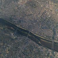
Photogrammetry captures Orléans city, delivering high-resolution 3D models that showcase Pont George-V and historic sites, while optimizations reduce image data and CPU load, boosting frame rates. …
 France
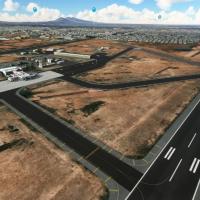
An add-on recreates Abraham González International Airport in Ciudad Juárez with a custom terminal building featuring jetways, a distinct control tower, and ongoing enhancements add a GA terminal a…
 Mexico
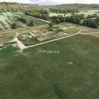
LFNT features three grass runways configured as 17R/35L, 17L/35R, and 12/30, anchoring a compact light-aviation environment with operational realism and historical charm. Daylight operations prevai…
France
The replica focuses on a true-to-scale runway and apron, presenting precise taxiway lines, hold-short markings, and aircraft parking spots, complemented by a custom terminal and advanced night ligh…
Mexico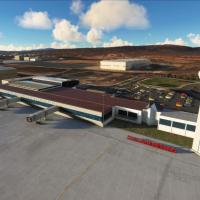
The MMQT add-on recreates Querétaro's Intercontinental Airport with a custom terminal model and a realistically modeled control tower. Cosmetic jetways remain non-functional, and the layout is repr…
Mexico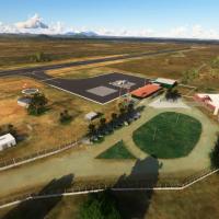
A freeware add-on recreates Quixadá's aerodrome SNQX with a 1200x30m asphalt runway 14/32. It centers on executive aviation and air taxis, and highlights regional landmarks such as Pedra da Galinha…
 Brazil
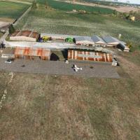
LFCP at Avy features an unsurfaced grass runway 13/31 measuring 1,250 by 80 meters, plus a parking area, several hangars, and a refueling station. Version 1.1 enhances the ground appearance, adds C…
France
Amado Nervo International Airport in Tepic receives a meticulous enhancement featuring a custom terminal, control tower, and a redesigned runway with aligned ground markings and parking areas, comp…
Mexico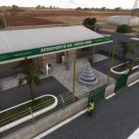
Crateús Airport SNWS receives a freeware enhancement that precisely mirrors its 08/26 runway, a 1500 by 30 meter asphalt strip. The enhancement adds terminals, hangars, fences, and signage, mirrors…
Brazil