 FS2004 Scenery
Himalayas LOD9 Base Mesh - Kashmir
This freeware add-on provides an enhanced terrain mesh focused on coordinates…
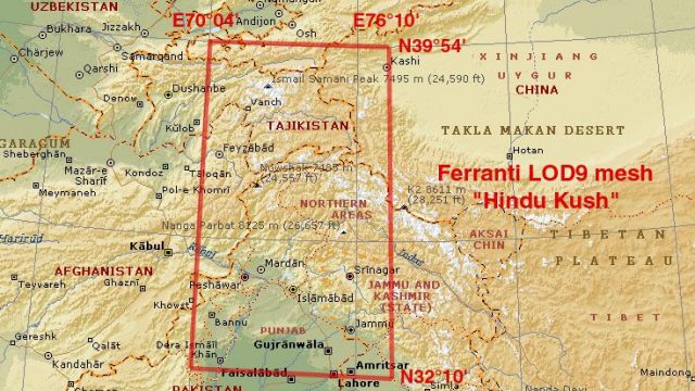
High-resolution LOD9 terrain mesh reshapes the Hindu Kush between N32°–40° and E70°–76°, blending Shuttle Radar Topography Mission data with refined elevations from topographic mapping to eliminate voids and sharpen ridgelines, passes, and valleys. Built for Microsoft Flight Simulator 2004, it also supports FS2002 for more faithful mountain flying and planning.
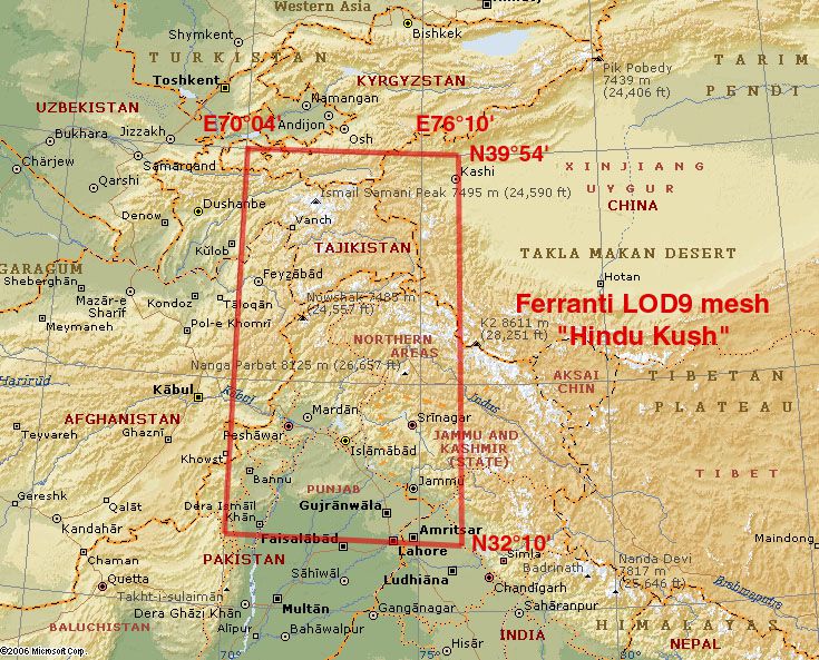
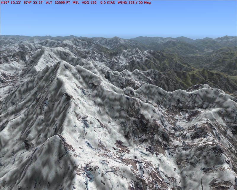
This comprehensive terrain mesh package provides an enhanced representation of the Hindu Kush range, focusing on the coordinates N32°-40°, E70°-76°. Featuring carefully integrated Shuttle Radar (SRTM) data and supplementary elevation details from topographic maps (compiled by Jonathan de Ferranti), it offers an especially intricate landscape for simmers who prioritize accuracy within Microsoft Flight Simulator 2004. Additionally, it maintains full compatibility with FS2002 and is distributed free of charge.
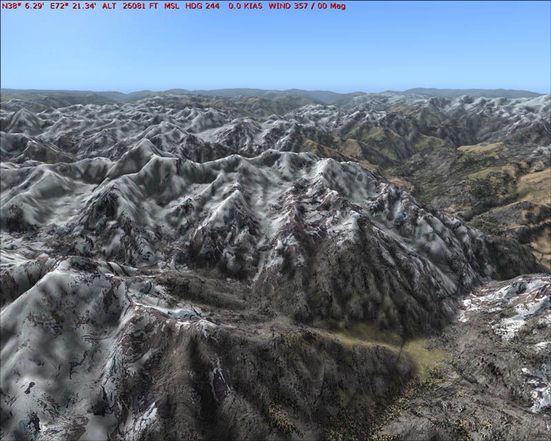
This add-on is part of a broader set of “LOD9 base mesh” releases, which depict the vast Himalayan region with impressive resolution. Numerous mountain passes and remote valleys gain definition from the seamless blending of void-free data, ensuring features far beyond default scenery clarity. With the mesh precisely compiled by Holger Sandmann, expect remarkable detail that preserves essential terrain characteristics—including rugged ridgelines and abrupt elevation shifts—essential for those who crave enhanced realism.
The primary dataset from SRTM surveys is enriched where necessary by carefully processed map-based height curves. This meticulous substitution method corrects data gaps common with raw radar acquisitions. As a result, sim pilots experience topography that aligns more closely with real altitude variations, making route planning across the Hindu Kush peaks and valleys substantially more immersive.
Beyond this core “LOD9 base mesh” collection, an optional “LOD10 Himalayan Peaks” layer is also available, which highlights particularly commanding summits and ridges. Installing this secondary enhancement augments overall authenticity while preserving performance for long-haul flights or complex approach procedures within mountainous terrain.
By refining contours and smoothing transitions, this mesh lets users enjoy more believable approaches and departures in these challenging highland regions. No more abrupt cliffs or cartoonish slopes—every contour is carefully resolved to aid both visual flight and instrument operations.
Free for all simmers · 85.72 MB · Scanned clean Jul 2026
Download speed: Free tier is capped at 0.5 Mbps (this file takes approximately 24 mins at the cap). PRO members download at full line speed.
FS9\Aircraft\, FS9\Addon Scenery\, FS9\Gauges\, or FS9\Effects\.readme.txt or README file. It tells you exactly where files go, what dependencies are needed, and any quirks specific to this add-on.The archive fs_him_b5.zip has 15 files and directories contained within it.
This list displays the first 500 files in the package. If the package has more, you will need to download it to view them.
| Filename/Directory | File Date | File Size |
|---|---|---|
| fs_him_b5 | 02.21.06 | 0 B |
| File_id.diz | 02.21.06 | 456 B |
| fs_him_b5.gif | 02.11.06 | 14.16 kB |
| Himalayan Base Mesh 5 - Hindu Kush | 02.21.06 | 0 B |
| Himalayas - Karakoram - Rakaposhi.jpg | 01.29.06 | 110.81 kB |
| Himalayas - Pamir - Batang Valley.jpg | 01.29.06 | 111.52 kB |
| map Himalayas base mesh - Hindu Kush.jpg | 02.06.06 | 253.10 kB |
| mesh Himalayas by Ferranti & Sandmann | 02.07.06 | 0 B |
| scenery | 02.21.06 | 0 B |
| mesh_Himalayas_base_Hindu_Kush_LOD7.bgl | 02.21.06 | 5.34 MB |
| mesh_Himalayas_base_Hindu_Kush_LOD8.bgl | 02.21.06 | 18.41 MB |
| mesh_Himalayas_base_Hindu_Kush_LOD9.bgl | 02.21.06 | 65.70 MB |
| readme fs_him_b5.txt | 02.21.06 | 8.92 kB |
| flyawaysimulation.txt | 10.29.13 | 959 B |
| Go to Fly Away Simulation.url | 01.22.16 | 52 B |
Only PRO members can place votes.
More FS2004 add-ons hand-picked based on this download.
FS2004 Scenery
This freeware add-on provides an enhanced terrain mesh focused on coordinates…
 FS2004 Scenery
Island of Tahiti, French Polynesia...FAAA, I.D. NTAA By: Bill Melichar This i…
 FS2004 Scenery
New York and New England 1-Arc Second LOD 10 Terrain Mesh Created from U.S. G…
 FS2004 Scenery
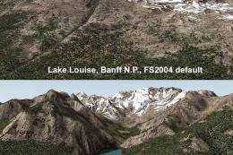
(N49-53, W112-116). All lake elevations are adjusted for best fit with the me…
 FS2004 Scenery
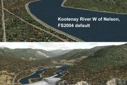
(N49-53, W116-120). All lake elevations are adjusted for best fit with the me…
 FS2004 Scenery
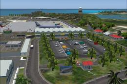
Princess Juliana is the scenery of the International Airport of St-Maarten in…
 FS2004 Scenery
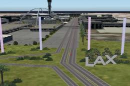
Airport Environment Upgrade 7.0 (AEU7) will greatly enhance the Microsoft® Fl…
 FS2004 Scenery
This is my first complete new scenery for FS2004, and it enhances the entry a…
Be the first to leave a comment on this download.
Be the first to share your thoughts on this download.