
FSX Flight Plan For OB-18 La Janta Colorado
OB-18 La Junta, Colorado delivers a fast, low-level IFR military training route across Colorado, New Mexico, Texas, and Oklahoma, built for high-performance jets and heavy bombers alike in Microsoft Flight Simulator X. It includes Terrain Following Radar and Pave Tack gauges, plus an optional v2.1 mini panel that streamlines both systems for realistic navigation, reconnaissance, and targeting.

 Prepar3D
- File: ob-18_lajunta_co.zip
- Size:661.6 KB
- Scan:
Clean (7d)
- Access:Freeware
- Content:Everyone
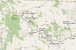
This comprehensive package offers a meticulously designed IFR high-speed, low-altitude military training route that begins near La Junta in Colorado and weaves through mixed landscapes in New Mexico, Texas, Oklahoma, and Colorado. Created by Bill McClellan, it is intended for Microsoft Flight Simulator X and provides a clear, structured flight path that enthusiasts of high-performance military aircraft will find invaluable. In particular, it is tailored for challenging operations with bombers and fighters such as the B-52, F-111, B-1B, B-2, A6, A4, or even the Vulcan. Still, it remains equally suited for any aircraft you might prefer to fly.
Core Features and Technical Elements
- Military-Oriented Flight Plan: This is the seventh in Bill McClellan’s series of specialized routes, focusing on low-level, high-speed segments that simulate real-world tactical operations.
- Varied Terrain: The route crosses a combination of flat plains and gentle rolling sections, immersing you in the typical geographic transitions found across New Mexico, Texas, Oklahoma, and central Colorado.
- Terrain Following Radar (TFR) Gauge (by Karol Chlebowski): This component facilitates consistent low-altitude flight with automatic terrain avoidance. The TFR gauge ensures you maintain the correct flight envelope, enabling precise adherence to the planned altitude constraints.
- Pave Tack System (by Karol Chlebowski): Integrated features for bombing runs, strategic reconnaissance, and advanced navigational tasks. The system supports precision targeting, making it an essential tool for conducting simulated military missions.
- Optional v2.1 Mini Panel: This alternative control panel consolidates the functions of TFR and Pave Tack, along with additional enhancements, into a single intuitive interface—ideal for pilots looking to streamline their cockpit tools.
Preparing for a Successful Mission
When planning your approach, take into account the flight plan’s low-altitude contours and high-velocity requirements. This route encourages you to exercise an aircraft’s full performance envelope, especially if you use strategic bombers with extensive operational ranges, such as the B-52 or B-1B. Likewise, advanced jets like the F-111 or Vulcan can benefit from this realistic terrain-following challenge.
Navigation and Situational Awareness
Thanks to the TFR and the Pave Tack gauges, managing altitude and target spotting is straightforward. Pilots who appreciate immersion will enjoy the complexity of maintaining IFR conditions while swiftly traversing valleys and plateaus.
Dynamics Across State Borders
During each phase of the flight, you will experience transitions between the arid sections in New Mexico and the more temperate zones in Colorado, creating a varied backdrop for instrument practice. This complexity adds multiple layers of engagement and encourages close attention to changing weather patterns across state lines.
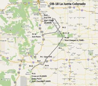
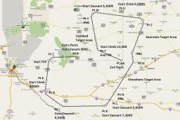
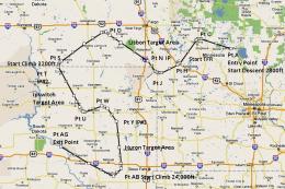
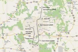
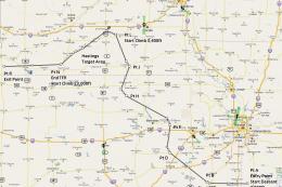
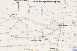
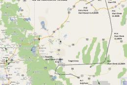
Visual depiction of the planned route system.
Further Enhancements
Although this flight plan is already extensive, flight simulation fans seeking advanced instrumentation can fly with expanded cockpit tools. By adding the v2.1 mini panel, you integrate both TFR and Pave Tack gauges for a more convenient experience, making low-level bombing runs, reconnaissance, and regional transitions smoother.
Creators and Recognition
Bill McClellan is the primary developer of this flight plan, and Karol Chlebowski provided the key gauges that transform the experience into an immersive training environment. Their collaboration delivers a top-tier freeware package that emphasizes realistic mission execution and navigational complexity in Microsoft Flight Simulator X.
Images & Screenshots
The archive ob-18_lajunta_co.zip has 15 files and directories contained within it.
File Contents
This list displays the first 500 files in the package. If the package has more, you will need to download it to view them.
| Filename/Directory | File Date | File Size |
|---|---|---|
| Approaching IP OB-18 La Junta Colorado.FSSAVE | 07.09.11 | 112.09 kB |
| Approaching IP OB-18 La Junta Colorado.WX | 07.09.11 | 325.89 kB |
| Entering OB-18 La Junta Colorado.FLT | 07.09.11 | 18.50 kB |
| Entering OB-18 La Junta Colorado.FSSAVE | 07.09.11 | 85.99 kB |
| Entering OB-18 La Junta Colorado.WX | 07.09.11 | 341.45 kB |
| OB-18 La Junta CO.jpg | 07.09.11 | 74.54 kB |
| OB-18 Lajunta CO.pln | 07.09.11 | 2.93 kB |
| Pave Tack Notes.doc | 06.16.11 | 327.50 kB |
| Pave Tack.cab | 07.05.11 | 633.89 kB |
| Read Me.txt | 07.09.11 | 12.30 kB |
| Targets OB-18 LaJunta.bgl | 07.01.11 | 3.05 kB |
| TFR.cab | 07.02.11 | 9.88 kB |
| Approaching IP OB-18 La Junta Colorado.FLT | 07.09.11 | 18.59 kB |
| flyawaysimulation.txt | 10.29.13 | 959 B |
| Go to Fly Away Simulation.url | 01.22.16 | 52 B |
Installation Instructions
Most of the freeware add-on aircraft and scenery packages in our file library come with easy installation instructions which you can read above in the file description. For further installation help, please see our Flight School for our full range of tutorials or view the README file contained within the download. If in doubt, you may also ask a question or view existing answers in our dedicated Q&A forum.


0 comments
Leave a Response