 FSX Scenery
FSX Skara Bonaire X
Skara Scenery Bonaire X. Flamingo International Airport or Bonaire Internatio…
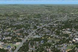
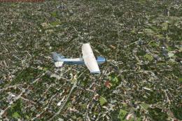
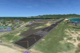
Scenery Of Algeri expands Algeria and the surrounding Sahara with about 50 airports, detailed coastal cities, authentic seaports, and landmark highlights such as Constantine’s Emir Abdel Kader Mosque, plus remote desert features around Tindouf and Tamanrasset. Built for FSX, it supports long-range VFR and radionav-guided routes from the Mediterranean to deep Sahara.
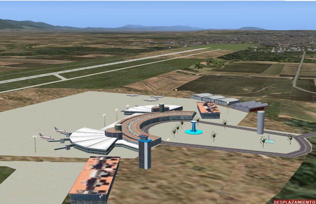
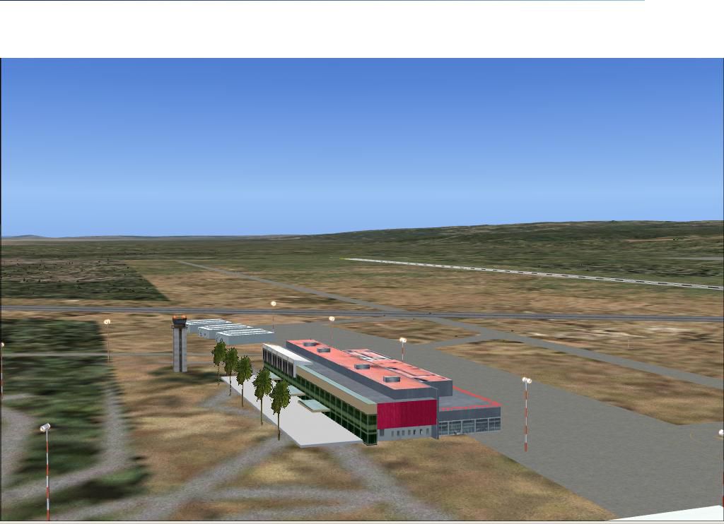
Scenery Of Algeri (Algeria) version I. Supplemented with Morocco 04 and Sahara 04. It contains 50 airports, some of them very real, and numerous cities located strategically around each one of the airports. They are the cities of the coast that show their sea ports with remarkable realism. In Constantine is reproduced the mosque Emir Abdel Kader. Also you can locate the camps of refugees of Tindouf...if he doesn't get lost for the desert. By Toni Agramont.
Scenery Of Algeri.
This scenario is supplemented with my Morocco and Sahara that you also located in AVSIM. They are all compatible ones with the present Algeri.
The designed territory is understood between the 35 54 N and 20 43 N and 001 46 W and 008 25 AND in its north area.
In the south part where the big deserts and ergs are it shows from Tindouf in the frontier with Morocco (008 55 W) until Illissi frontier with Tunisia (008 55 AND). Its total width in the north is of 940 kilometers.
In the South 1670 kilometers Its north depth to south is of 1816 kilometers. It culminates in the south in Tamanrasset and their dominant mountainous system in the area.
They can be carried out north trips to south until Tamanrasset guided by the corresponding radionavs or of Bechar until Ouarzazate and to continue toward the islands Canaries.
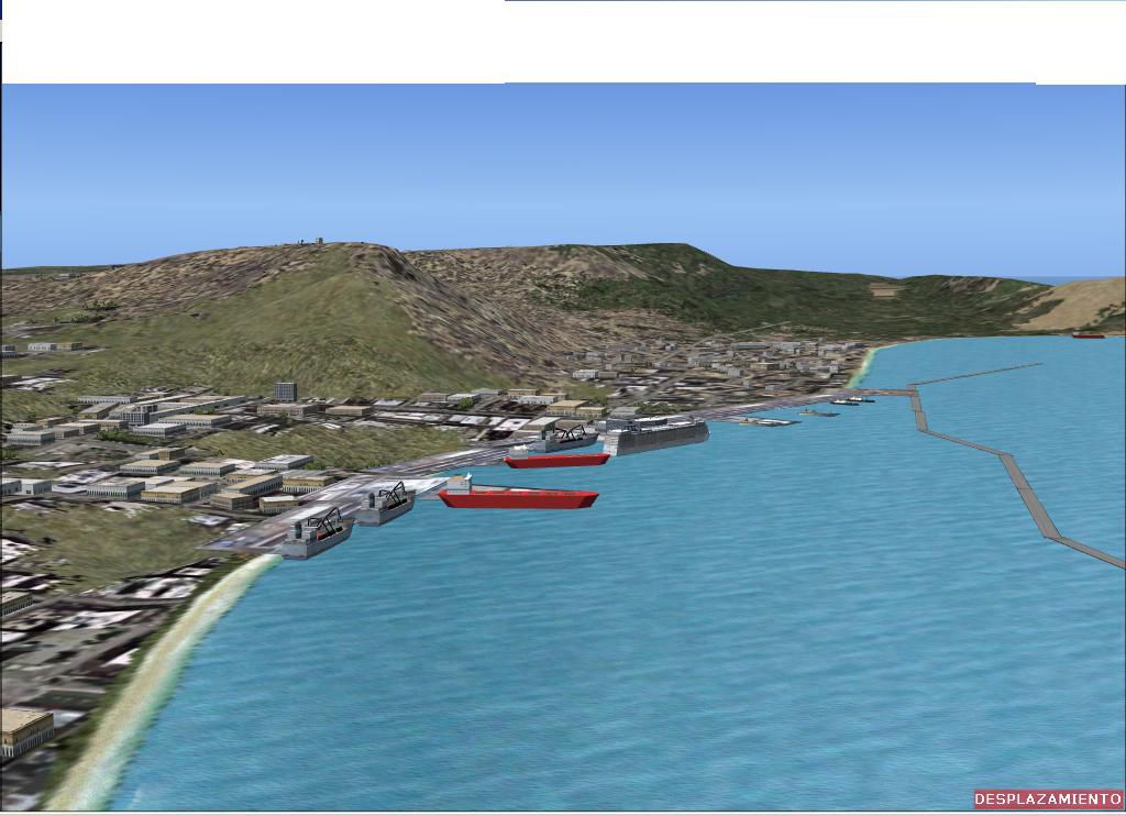
All the sea ports are authentic to the reality and mainly the terminals of Algier and they Pray. I recommend you a flight to low height for the coast.
The installation is the classic:
ADDON SCENERY
Algeri
Scenery
Texture
Finally to register in Library
Recommendations to keep in mind if one wants to obtain a good yield of the scenario.
You have two possibilities:
1º = AUTOGEN = max: beautiful houses but trees also hoist in the parking of the terminal of DAAG but here you won't have that to take the airplane but in the other parking to right.
2º = AUTOGEN = 0: NOT truth houses but the parking of the terminal of DAAG you see without you hoist.
Personally I prefer to see you hoist in the parking of DAAG and on the other hand to see beautiful cities.
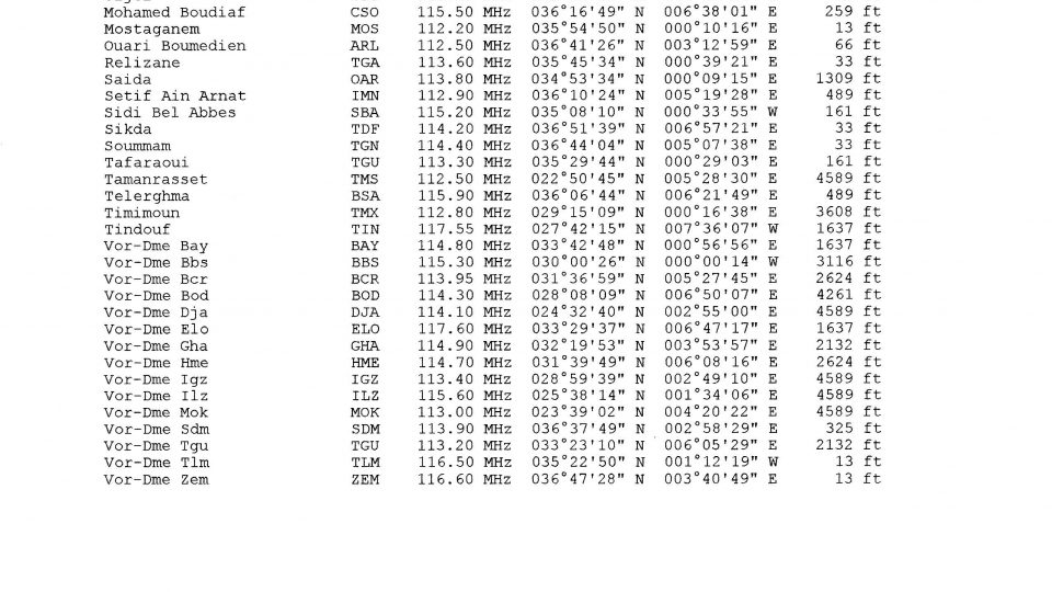
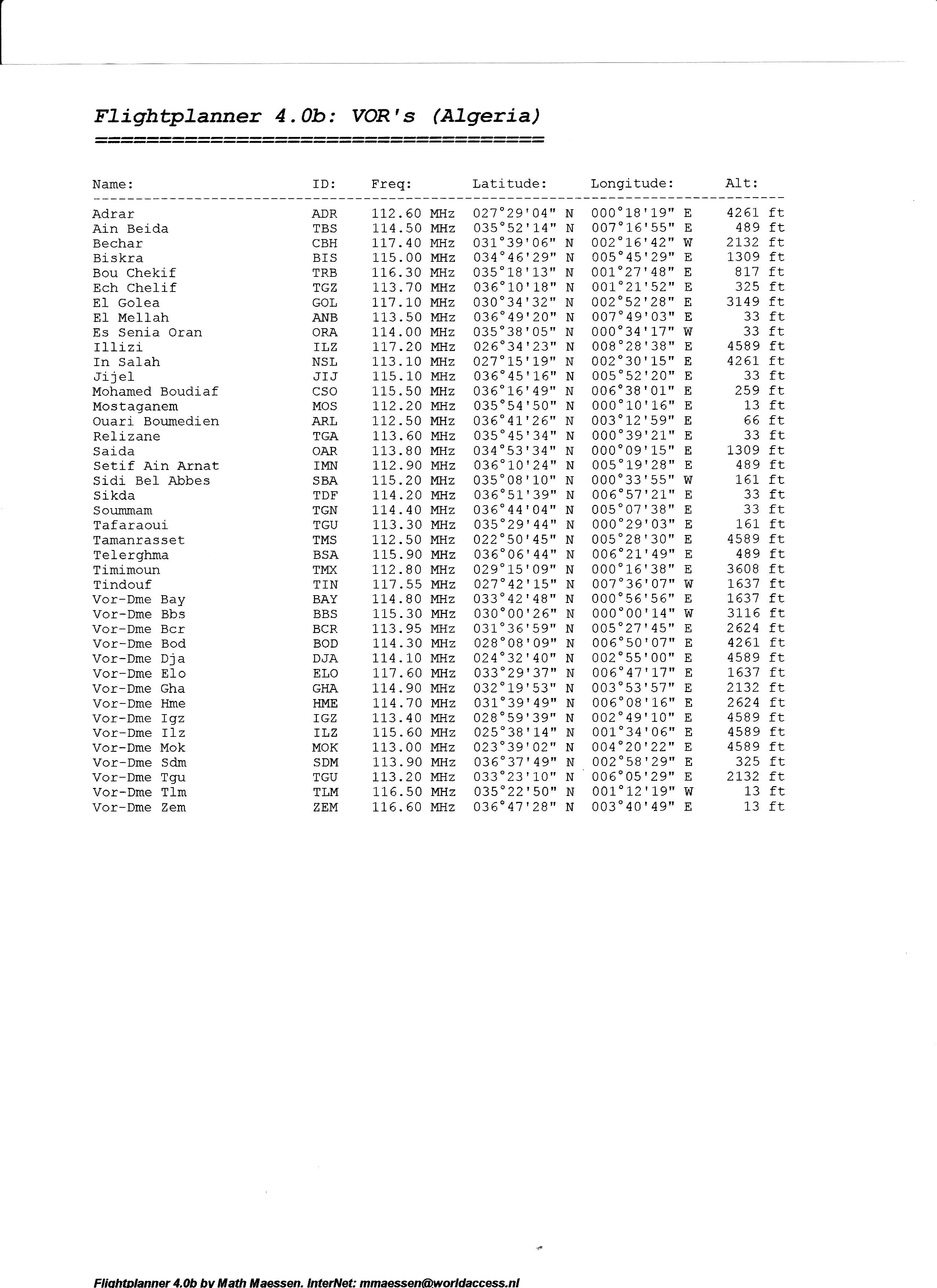
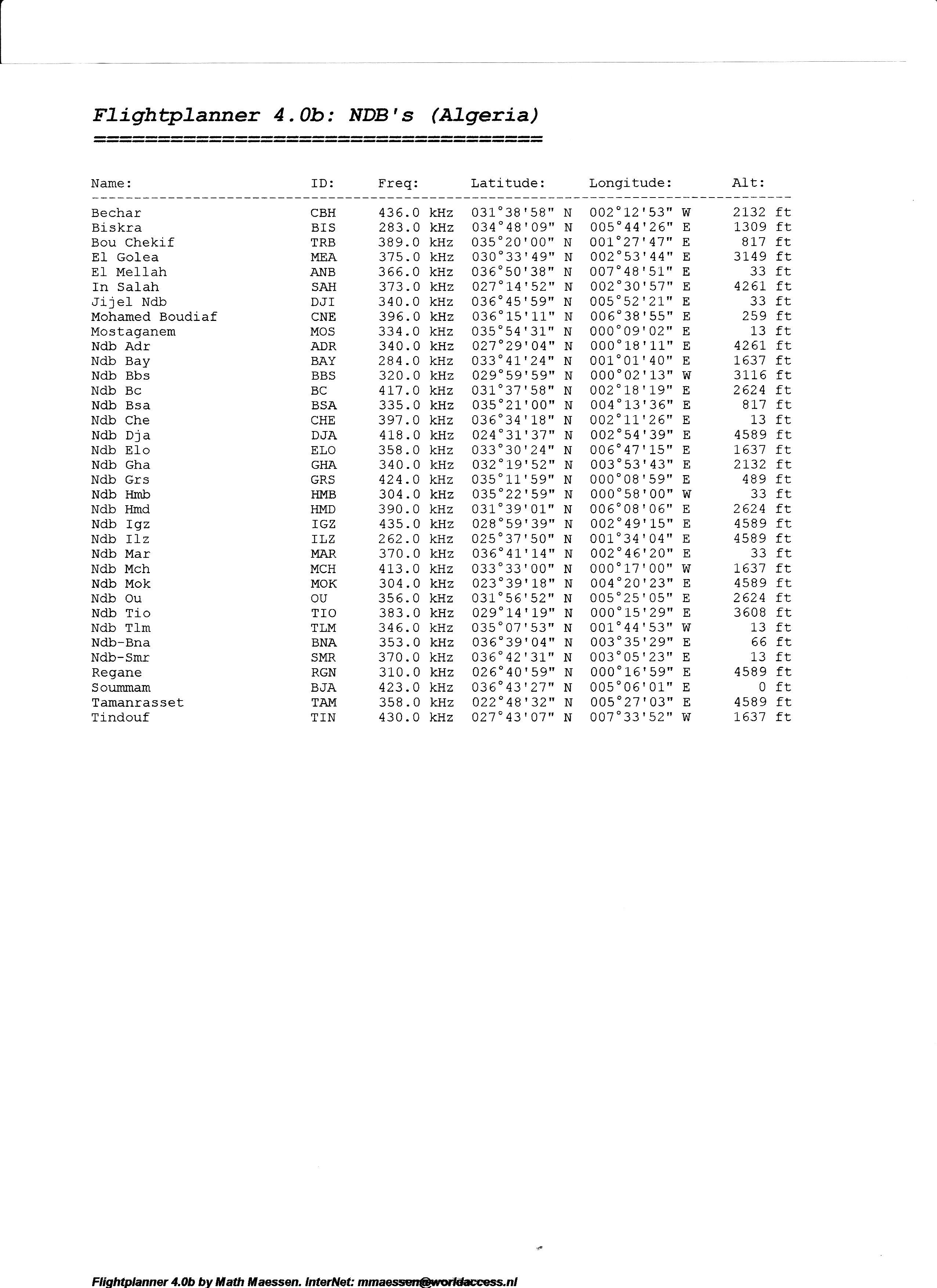
The radionavs comes in the figures VOR.jpg and NDB.JPG. There are them since scaned I had laziness from writing.
Toni

Scenery Of Algeri..
Free for all simmers · 26.39 MB · Scanned clean Jul 2026
Download speed: Free tier is capped at 0.5 Mbps (this file takes approximately 7 mins at the cap). PRO members download at full line speed.
FSX\Addon Scenery\ containing scenery and texture sub-folders.readme.txt or README file. It tells you exactly where files go, what dependencies are needed, and any quirks specific to this add-on.Use these coordinates to fly directly to this location once the mod is installed.
36.75380000,3.05880000
Launch FSX or Prepar3D and use Flights → Load to open the downloaded .pln file. Your aircraft will be positioned at this location.
The archive algeri_x.zip has 12 files and directories contained within it.
This list displays the first 500 files in the package. If the package has more, you will need to download it to view them.
| Filename/Directory | File Date | File Size |
|---|---|---|
| Lisezmoi.txt | 12.08.07 | 2.27 kB |
| NDB.jpg | 12.03.07 | 846.14 kB |
| OranHarbor.JPG | 12.03.07 | 98.33 kB |
| readme.txt | 12.08.07 | 2.28 kB |
| Scenery.zip | 12.08.07 | 2.43 MB |
| Texture.zip | 12.08.07 | 22.05 MB |
| VOR.jpg | 12.03.07 | 999.93 kB |
| DAAG.JPG | 12.04.07 | 122.63 kB |
| DAOO.JPG | 12.03.07 | 80.51 kB |
| FILE_ID.DIZ | 12.08.07 | 548 B |
| flyawaysimulation.txt | 10.29.13 | 959 B |
| Go to Fly Away Simulation.url | 01.22.16 | 52 B |
Only PRO members can place votes.
More FSX & P3D add-ons hand-picked based on this download.
FSX Scenery
Skara Scenery Bonaire X. Flamingo International Airport or Bonaire Internatio…
 FSX Scenery
Iwo Jima Scenery 1945 Update. This is a complete scenery with added effects a…
FSX Scenery
Kjeller Area Scenery X, Norway. Scenery around Kjeller airport with photoreal…
 FSX Scenery
FSX Loney's Alaska For FSX. This is a compilation of the author's Alaskan sce…
 FSX Scenery
For users of Flight Simulator X (and FSX: Steam Edition) and/or Prepar3D, ter…
 FSX Scenery
This freeware release by developer Aime Leclercq introduces revised highways …
 FSX Scenery
Team GEX Enhanced Autogen World. This package upgrades 522 world wide autogen…
 FSX Scenery
Princess Juliana International Airport (TNCM) in Saint Marteen, Netherlands A…
Be the first to leave a comment on this download.
Be the first to share your thoughts on this download.