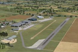
 FSX Scenery
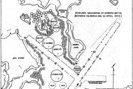
WWII Seaplane Aerodromes
WWII Scenery Seaplane Aerodromes. Thirteen Pacific Theater locations. Main em…
Allied WWII airfields across India, Burma, and China bring the CBI theater to life for historical missions and navigation training in FSX, with era-appropriate NDBs plus low-frequency radio range stations and North Atlantic ferry routes. Included maps, diagrams, and period approach charts support realistic route planning, and radio range leg guidance requires a compatible gauge.
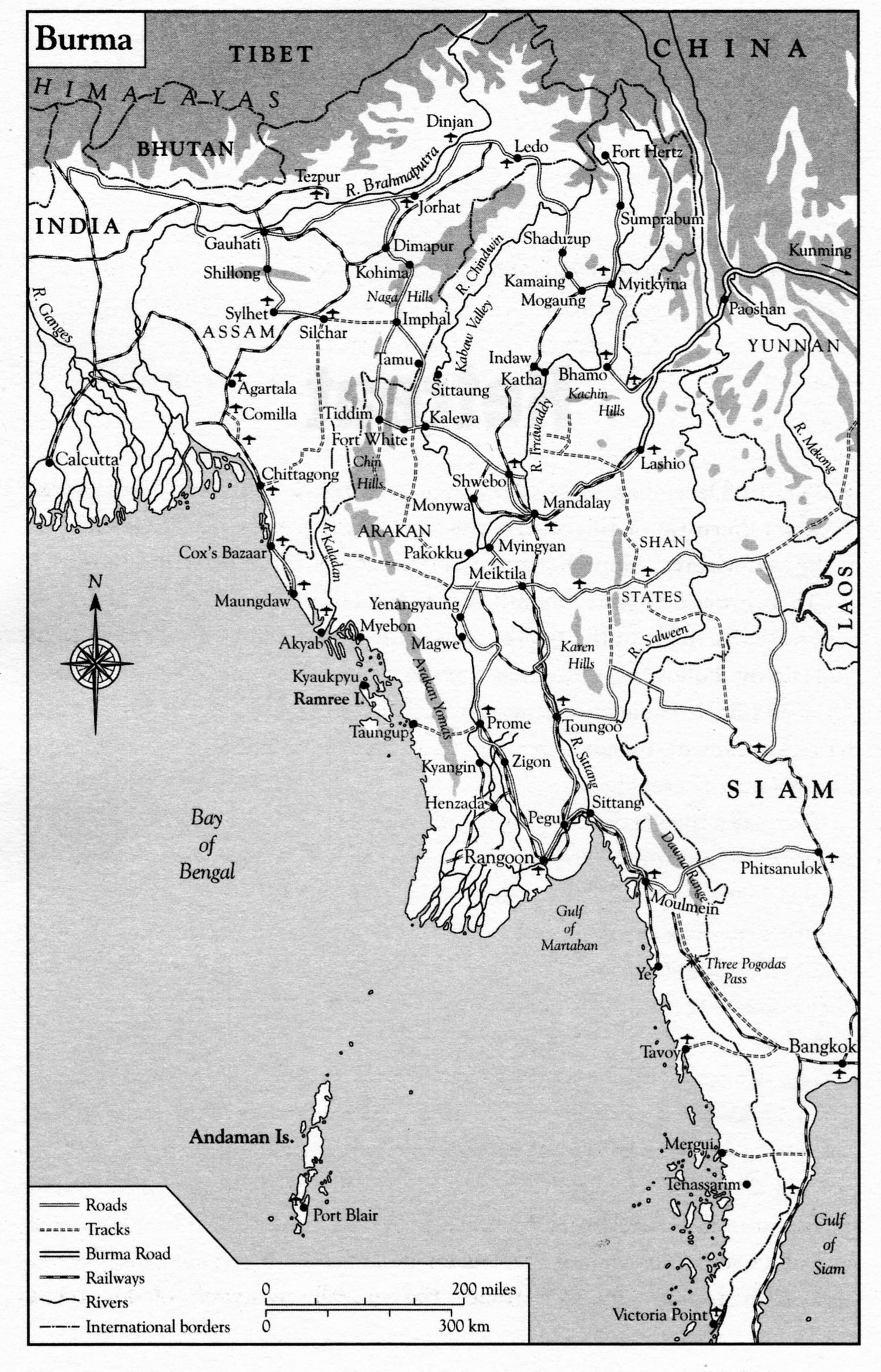
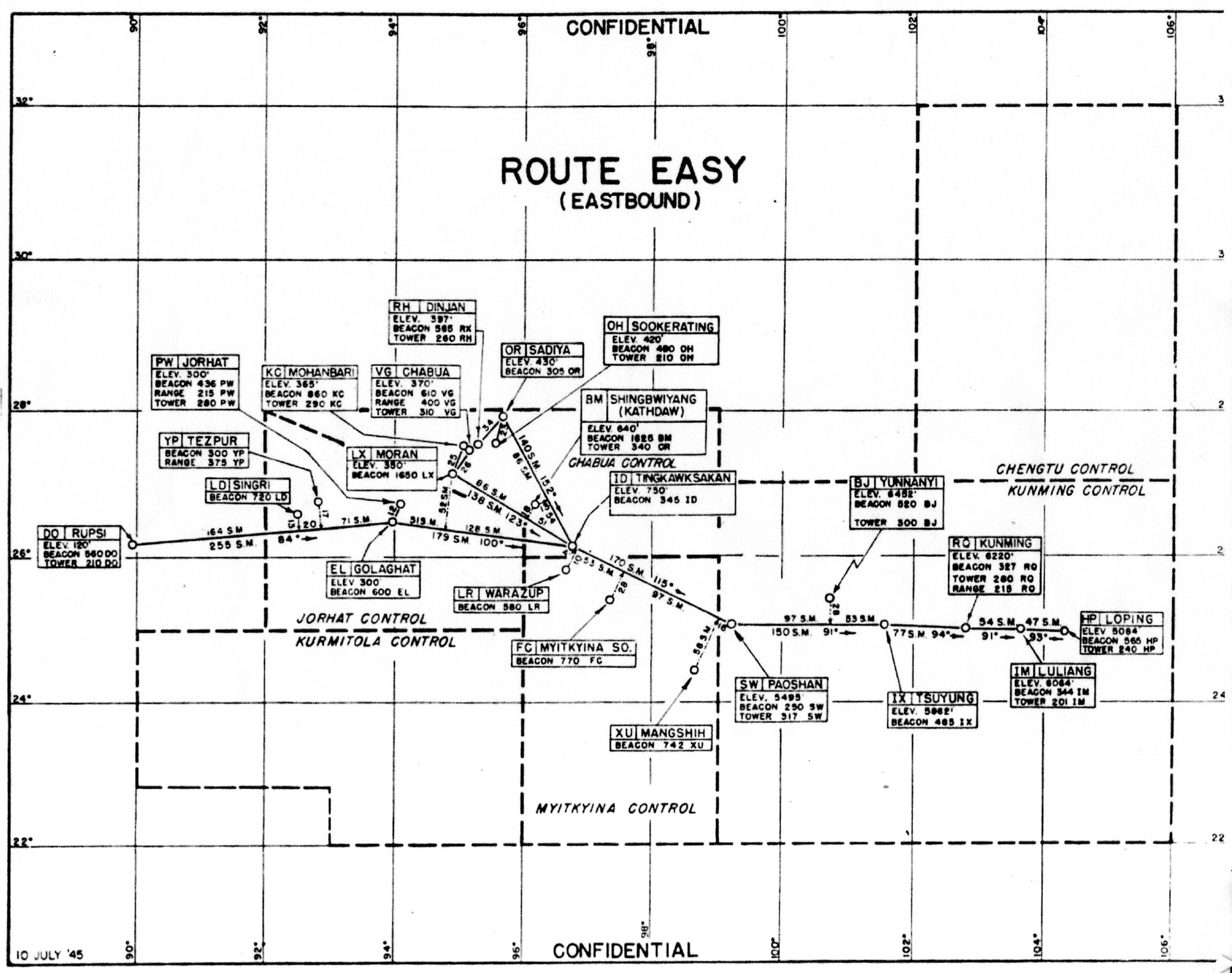
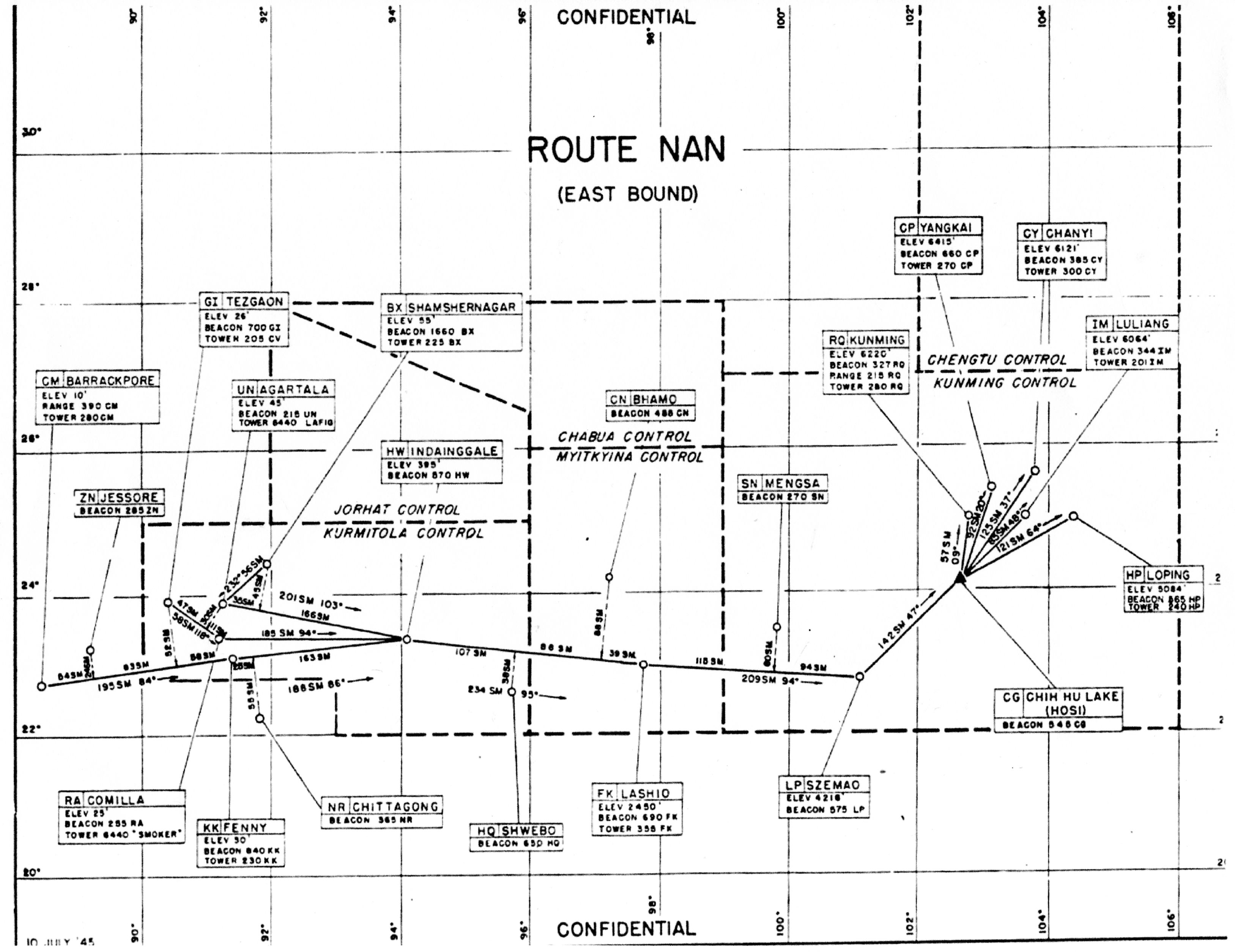
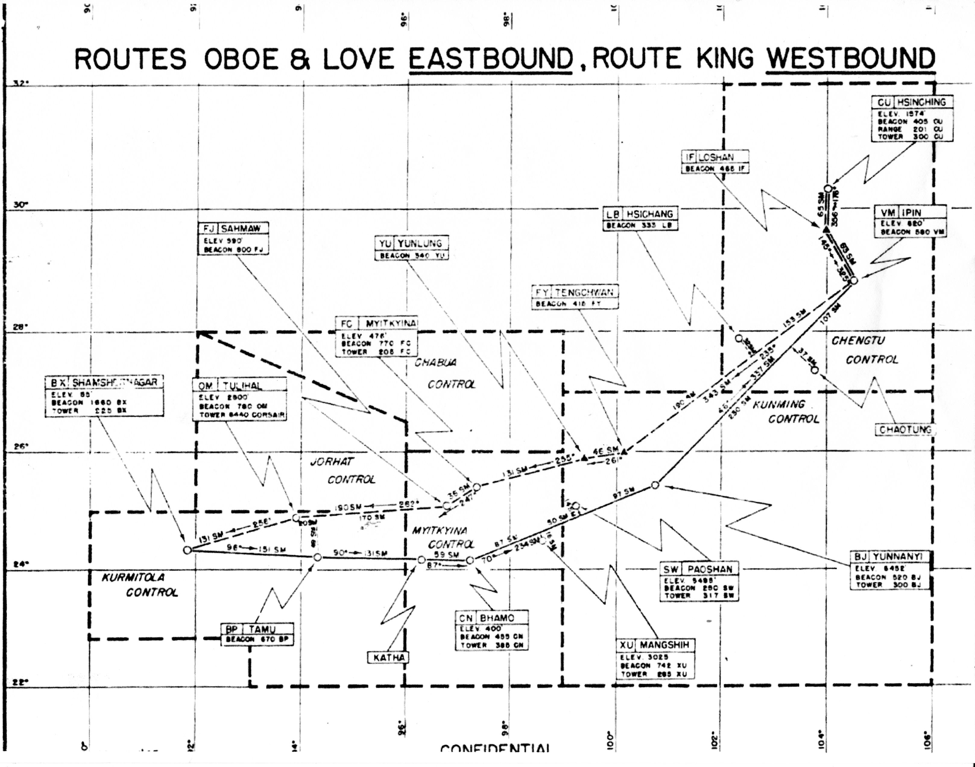


Allied WWII Airfields In China Burma India. Also radio range stations on North Atlantic route. Includes maps and diagrams. By Alex D. Nicolson.
Scenery Contents:
WWII airfields in INDIA
WWII airfields in BURMA
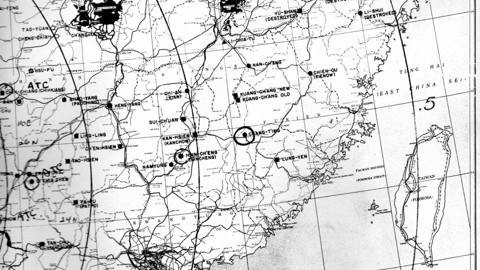
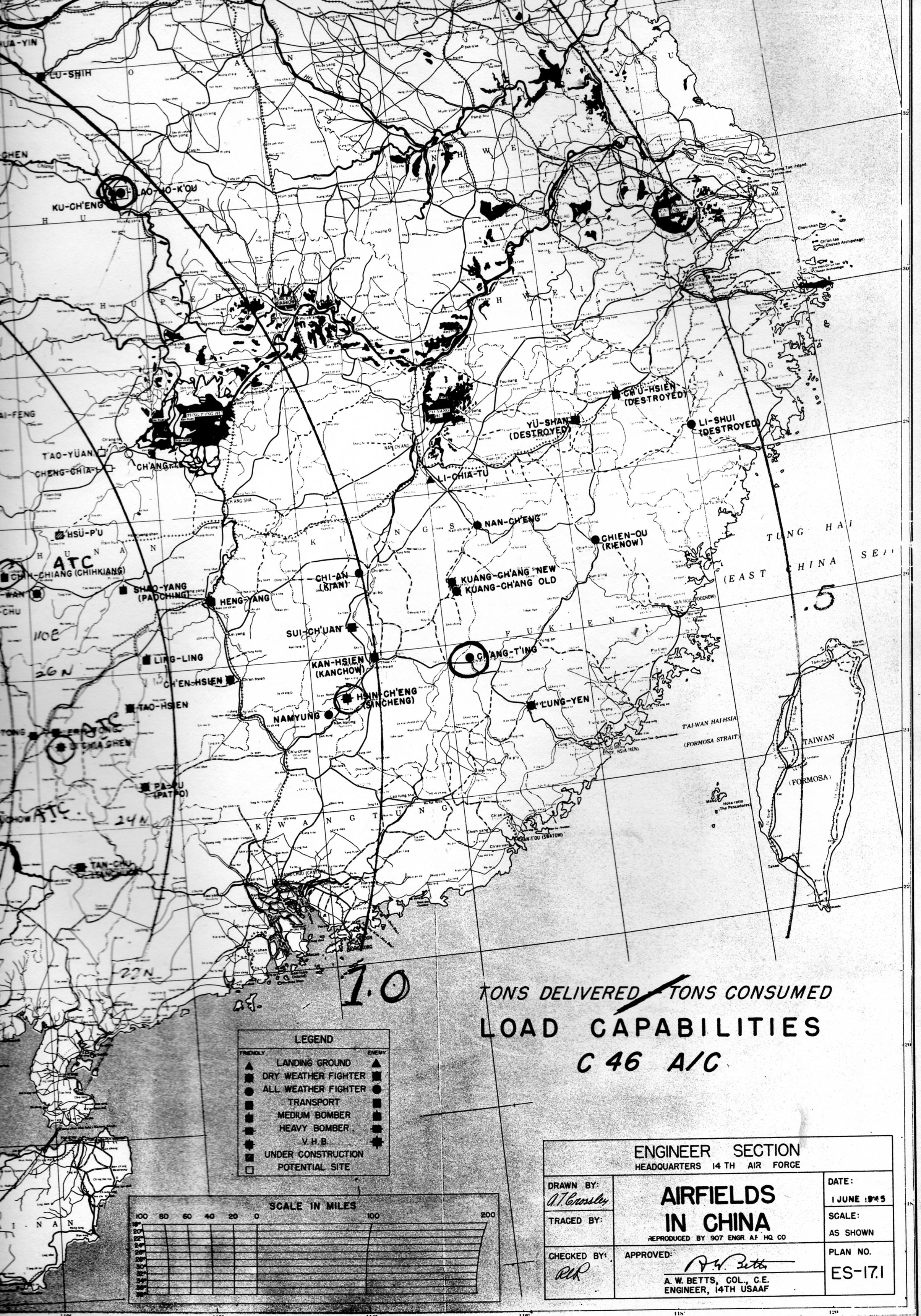
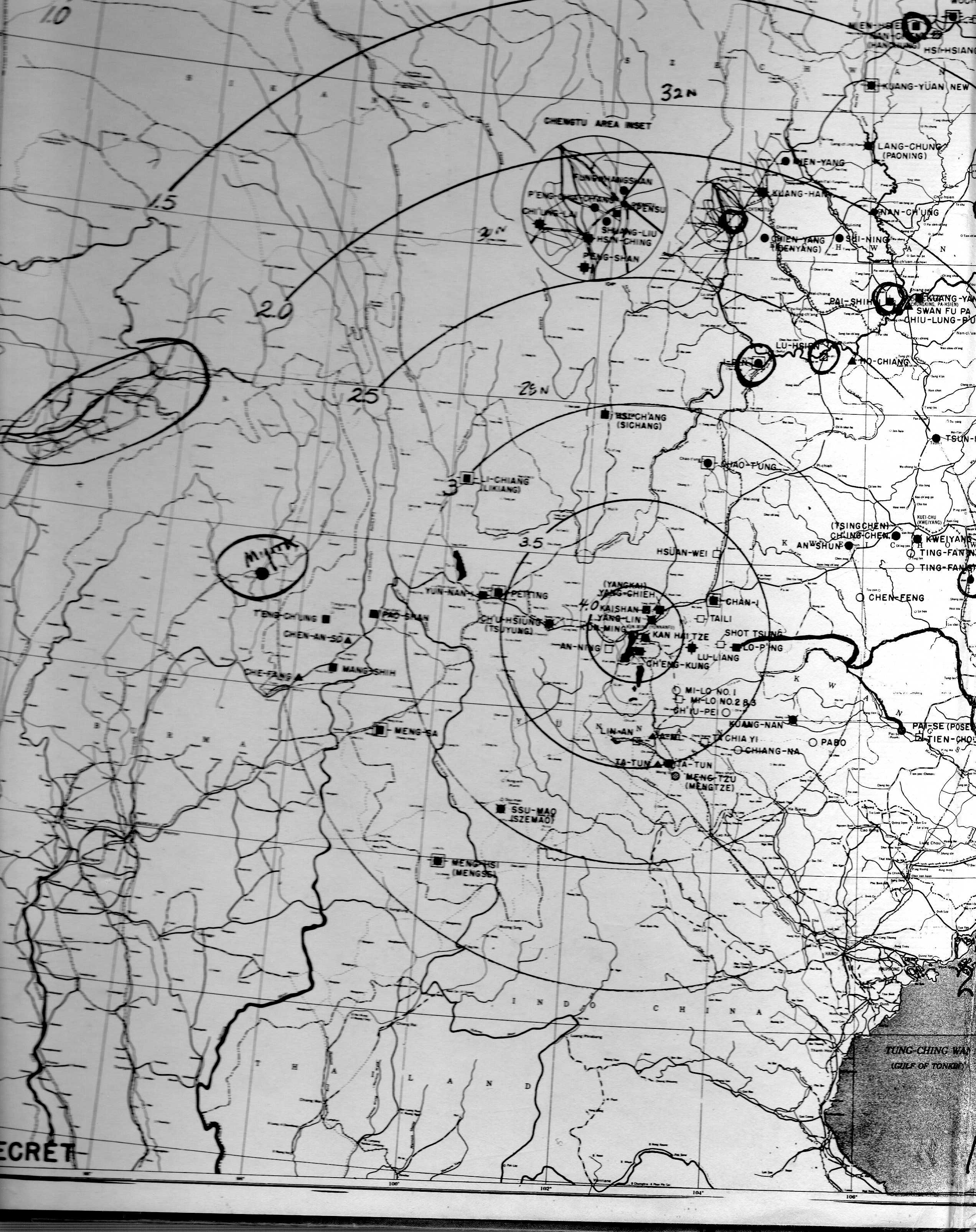
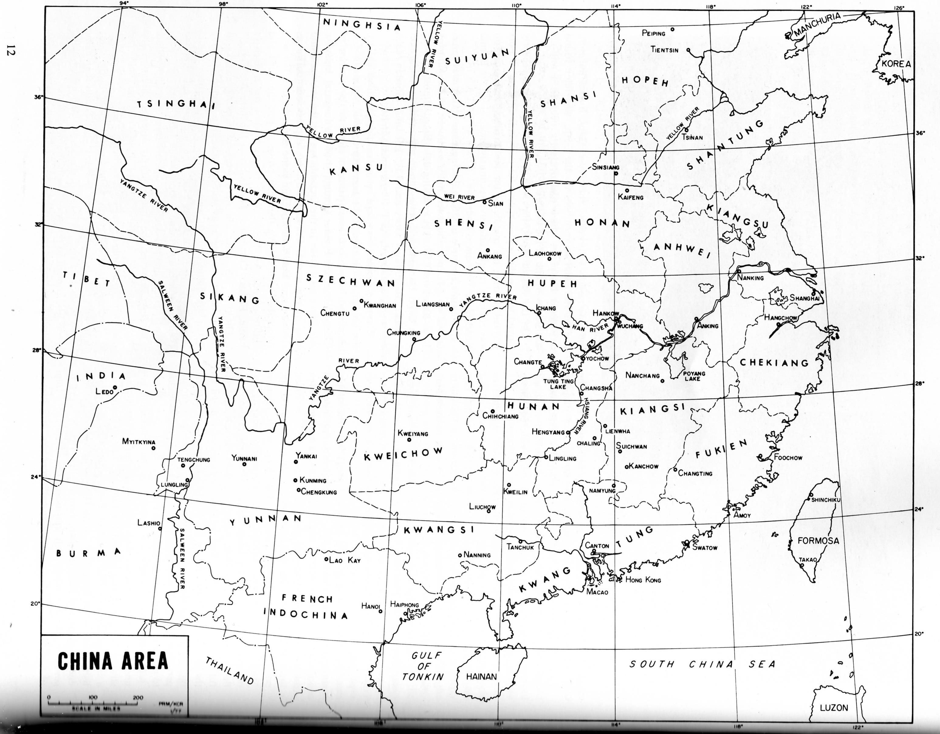
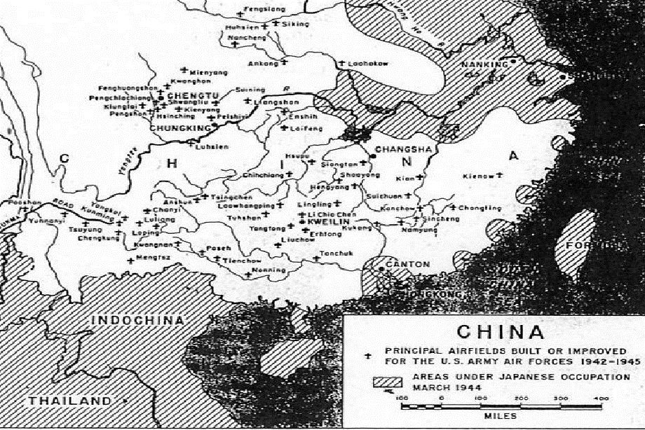
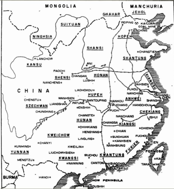
WWII airfields in CHINA
WWII Radio Range Stations on NORTH ATLANTIC Route
1. UNZIP the "CBIX.zip" file to a temporary folder. (not FSX)
In this temporary folder you will find a "CBIX" folder with 5 sub-folders and 2 files, as shown:
CBIX
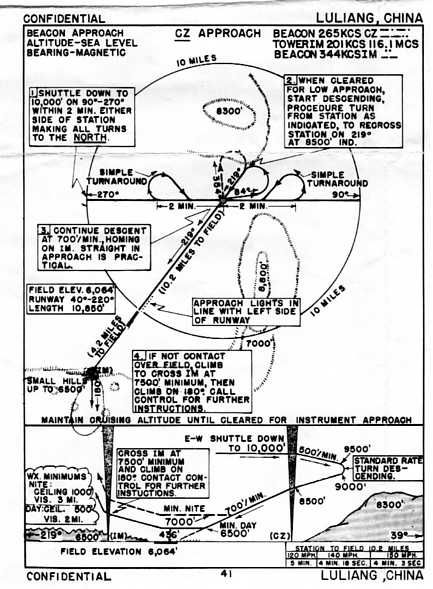
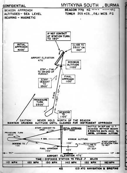
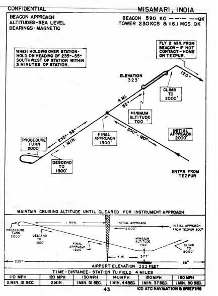
Approach Charts (Some period IAP charts)
Docs (Documentation)
Maps (Maps and Diagrams)
Scenery (Scenery files)
Texture (Empty)
CBIX Installation.txt (this file).
CBIX Readme First.txt (describing the project. Read this please.)
The "Docs" folder contains, "CBIX airfields.doc" in MsWord 97 format, as "CBIX airfields.odt" for Open Office, and as "CBIX airfield.pdf" as an alternative. This is the listing of the included stations, showing the data for each station.
2. COPY the complete "CBIX" folder into your FSX "Addon Scenery" folder.
3. ACTIVATE the scenery in your FSX Library in the normal manner.
4. To REMOVE this scenery, delete it from your FSX Library and delete the complete "CBIX" folder from "Addon Scenery"
5. All files are Copyright and for strictly individual personal use only.
All Airfields are readily accessible through FSX's "Go To Airport" menu by their CBIX assigned idents.
Station to Station MH and Statute Mile distances are for DR guidance only. Homer Beacon Ndb to Runway data is accurate.
Weather information was received directly from Towers by R/T on Tower Low Frequencies e.g. 380 Kc/s, as was Taxi information. Enroute Wx by Radio Operator, W/T or R/T on HF. This is not yet possible in FSX, so such simulated Communicatons are unfortunately necessarily VHF.
Available actual weather is sparse through the Hump area. Primarily Mohanbari, Fort Hertz and Kunming. So realistic realtime enroute "Hump" weather is frequently inaccurate. "ASE" helps and "Weather Underground" Hong Kong has better coverage in my opinion.
For USAAF flights ATC control and DF fixes only appeared much later, as did some Loran-C.
C.N.A.C existed as a seperate and independent civilian organization before, during and after WWII. They were the originators of the "Hump" routes subsequently greatly expanded by the USAAF. Lufthansa's "EurAsia" China operations ceased in 1941 due to Japanese attacks on their aircraft and brewing political factors.
Known Low Frequency Radio Range Stations are present, but activation requires the presence of an appropriately coded Radio Range gauge. In the absence of this gauge LF RadioRange stations function as a normal Ndb – without leg guidance.
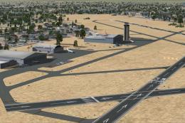
As with my two prior Flight Simulator versions of this scenery, the airfields are primarily intended for simulating WWII actual flights, historical Missions and for navigational exercises.
Their placement, Data and layout are as accurate as my available information data. Runway surfaces were generally crushed rock in China and could be anything in other areas. Again, information is rarely available.
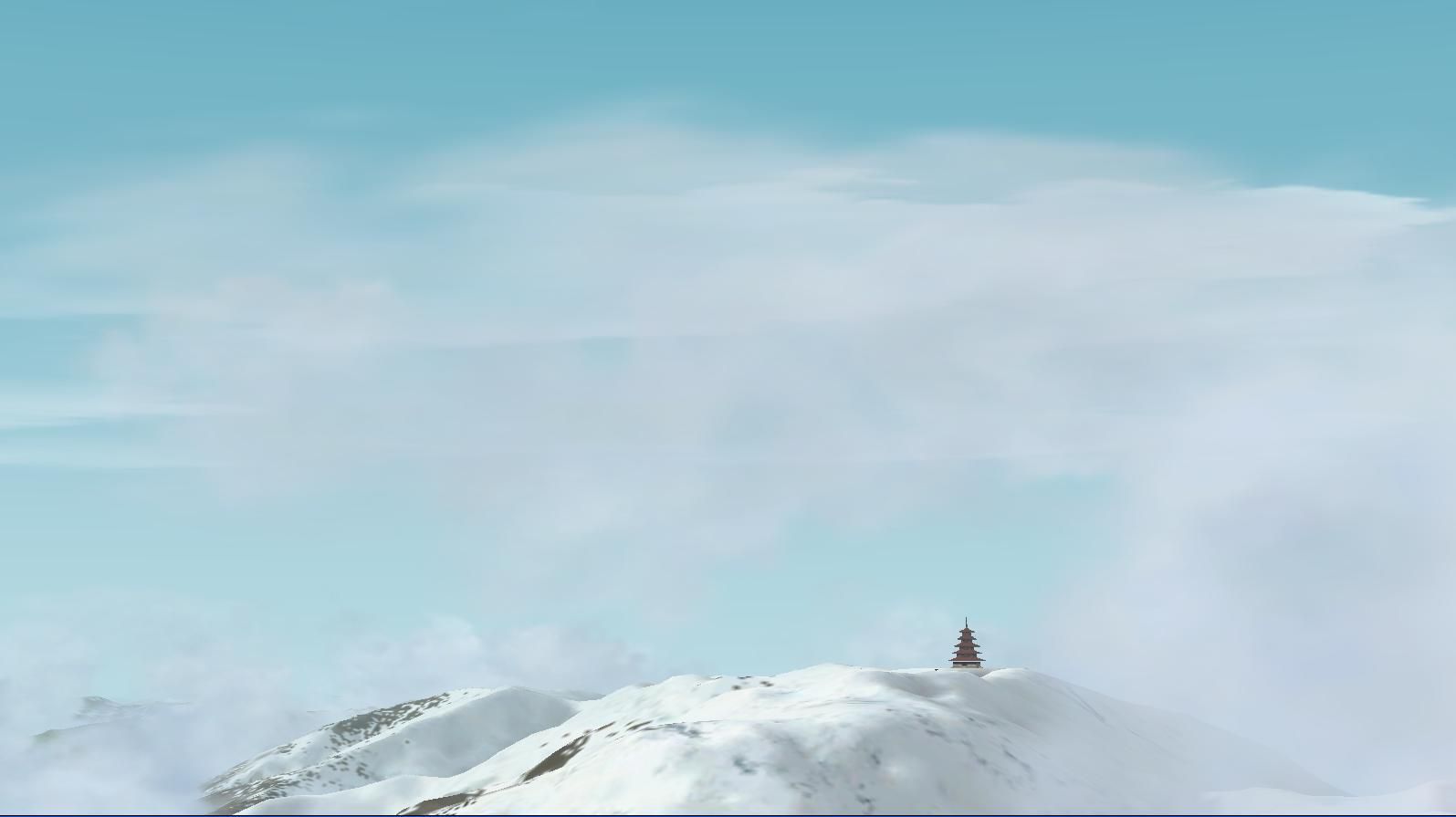
Scenery objects are only sufficent to provide some depth perception and regrettably do not usually appear as they actually were in 1943.
Period Navigation facilities were only NDB, and where available LF Radio Range stations. Atmospherics (QRN) throughout this area frequently render both communications and navigation problematic. ADF receivers, used primarily by US aircraft, are particularly vulnerable, either locking on the nearest Thundhead crashes, or spinning aimlessly.
Experienced Operators can sometimes produce an approximate LOP using Manual Loop and aural swings.
Use of GPS, VOR or Flightplan programs reduces the experience to an arcade game rather than a historic simulation and is not recommended in my opinion. I do not use robotic AI.
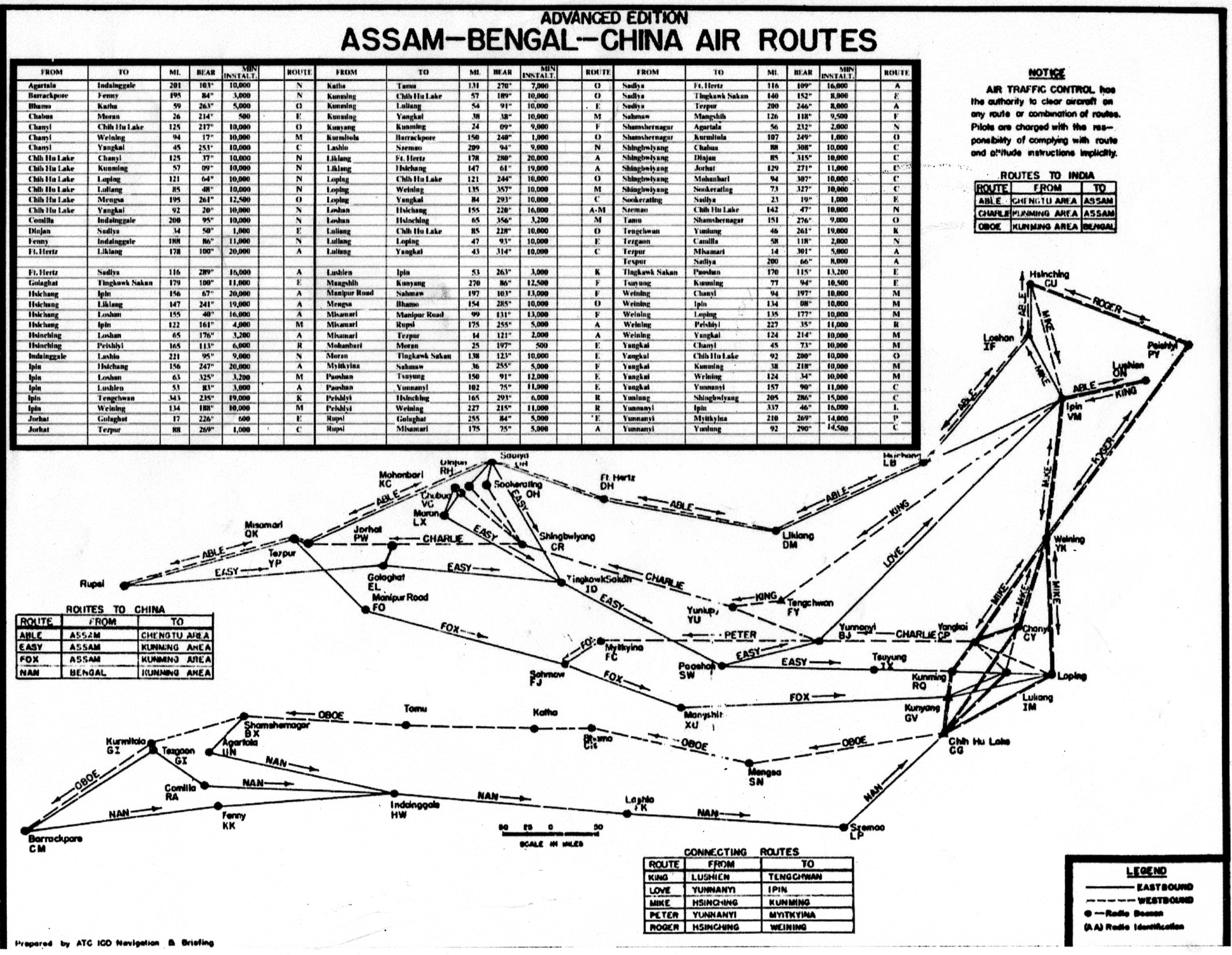
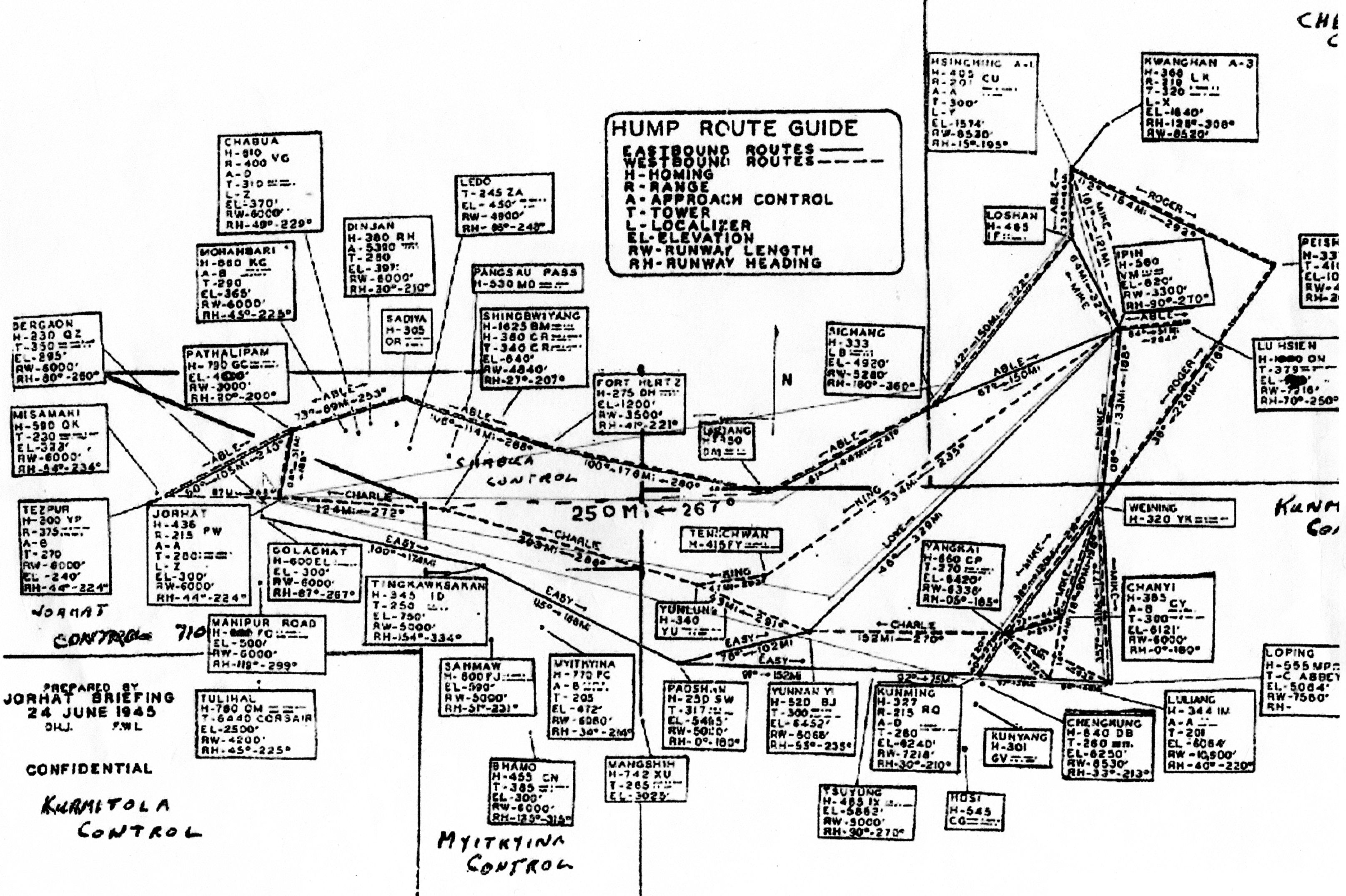
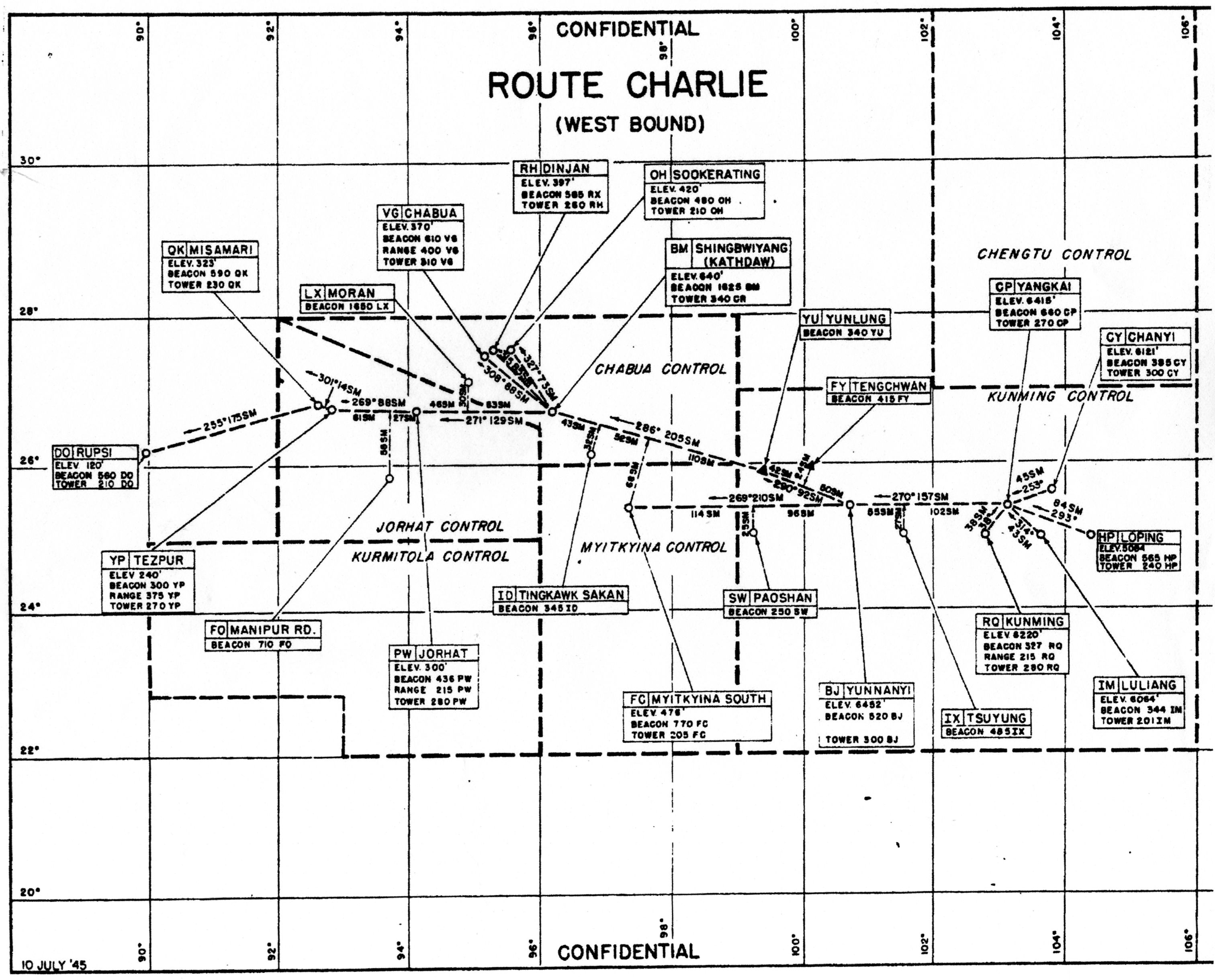
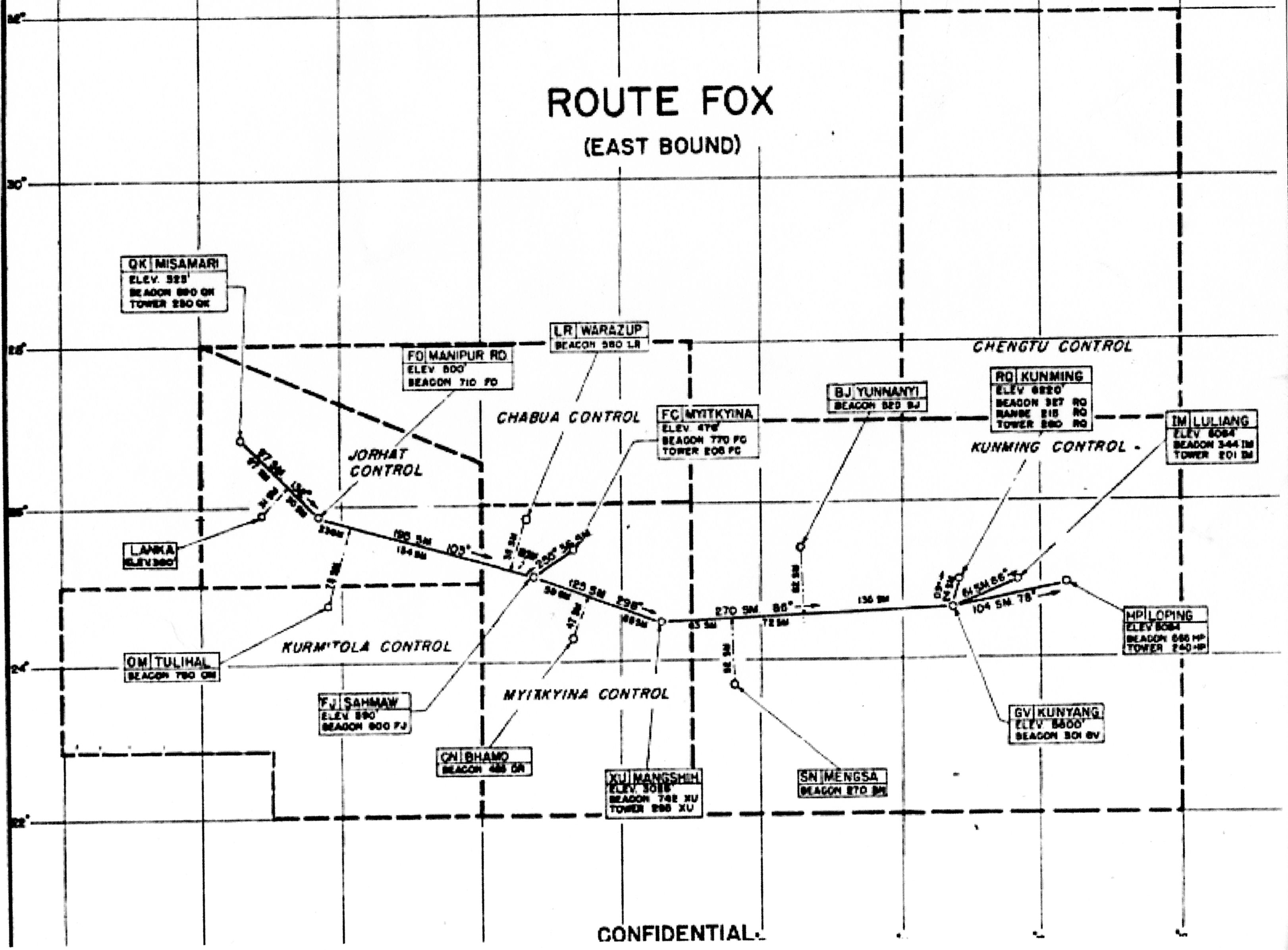
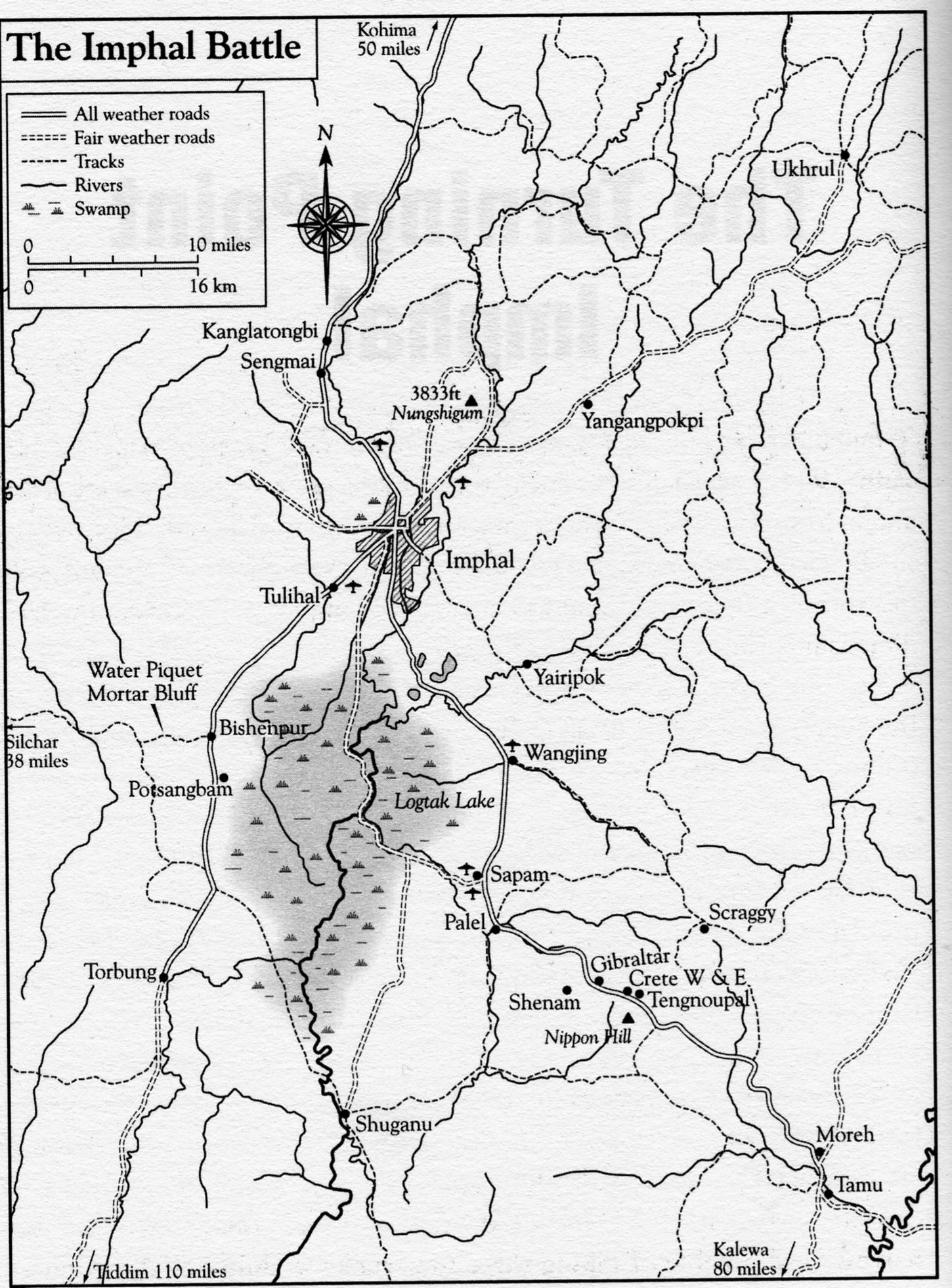
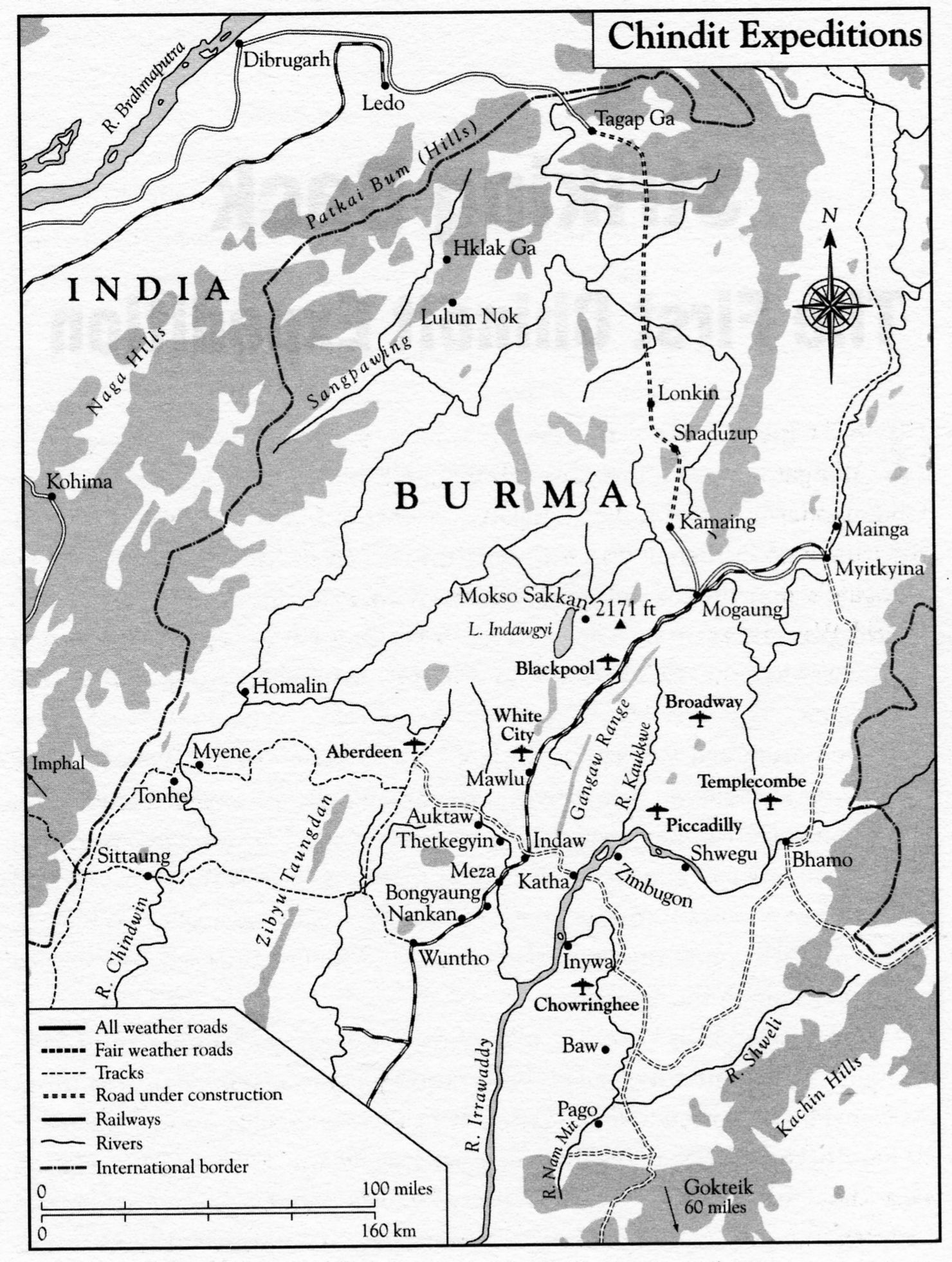
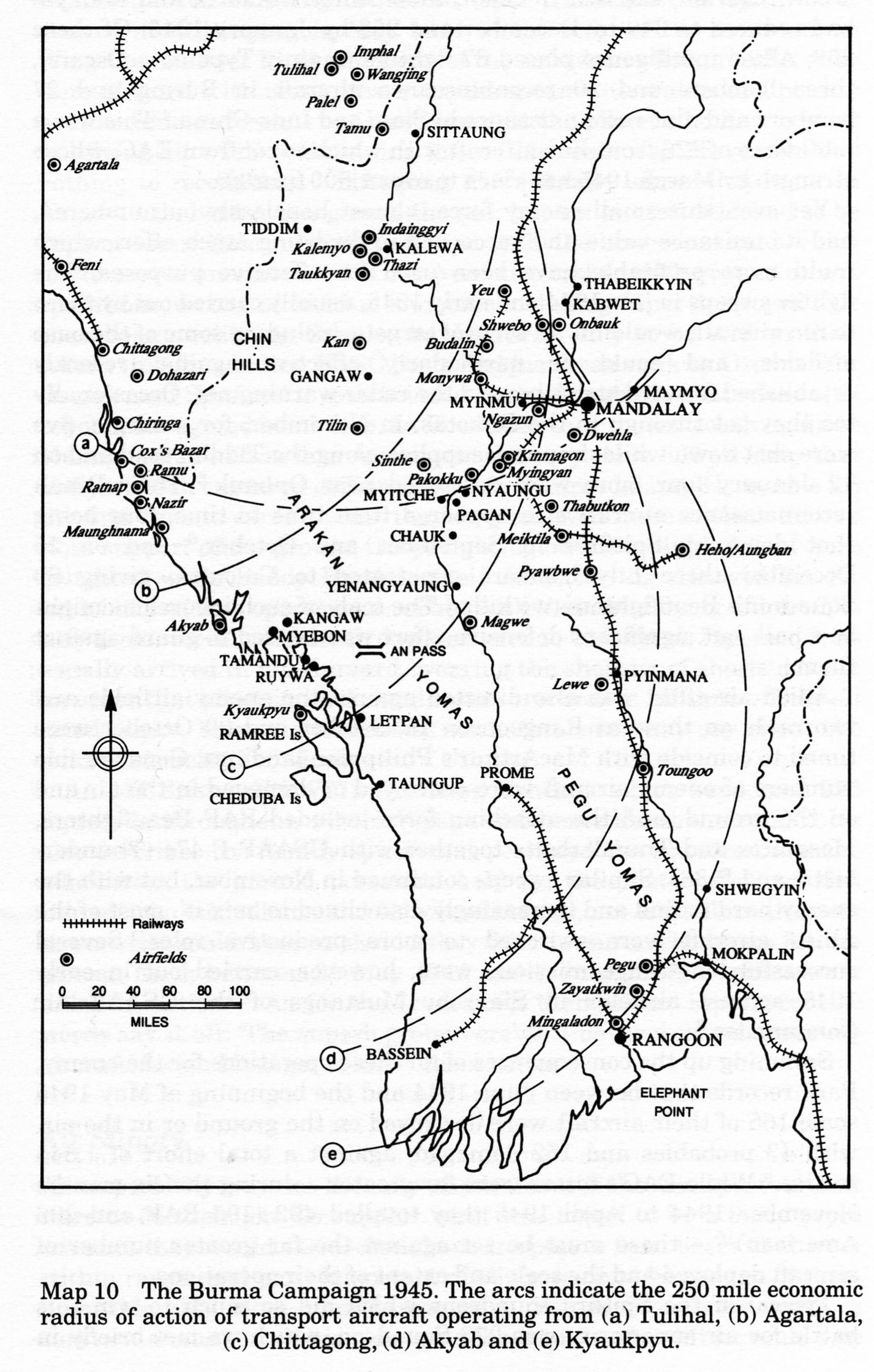
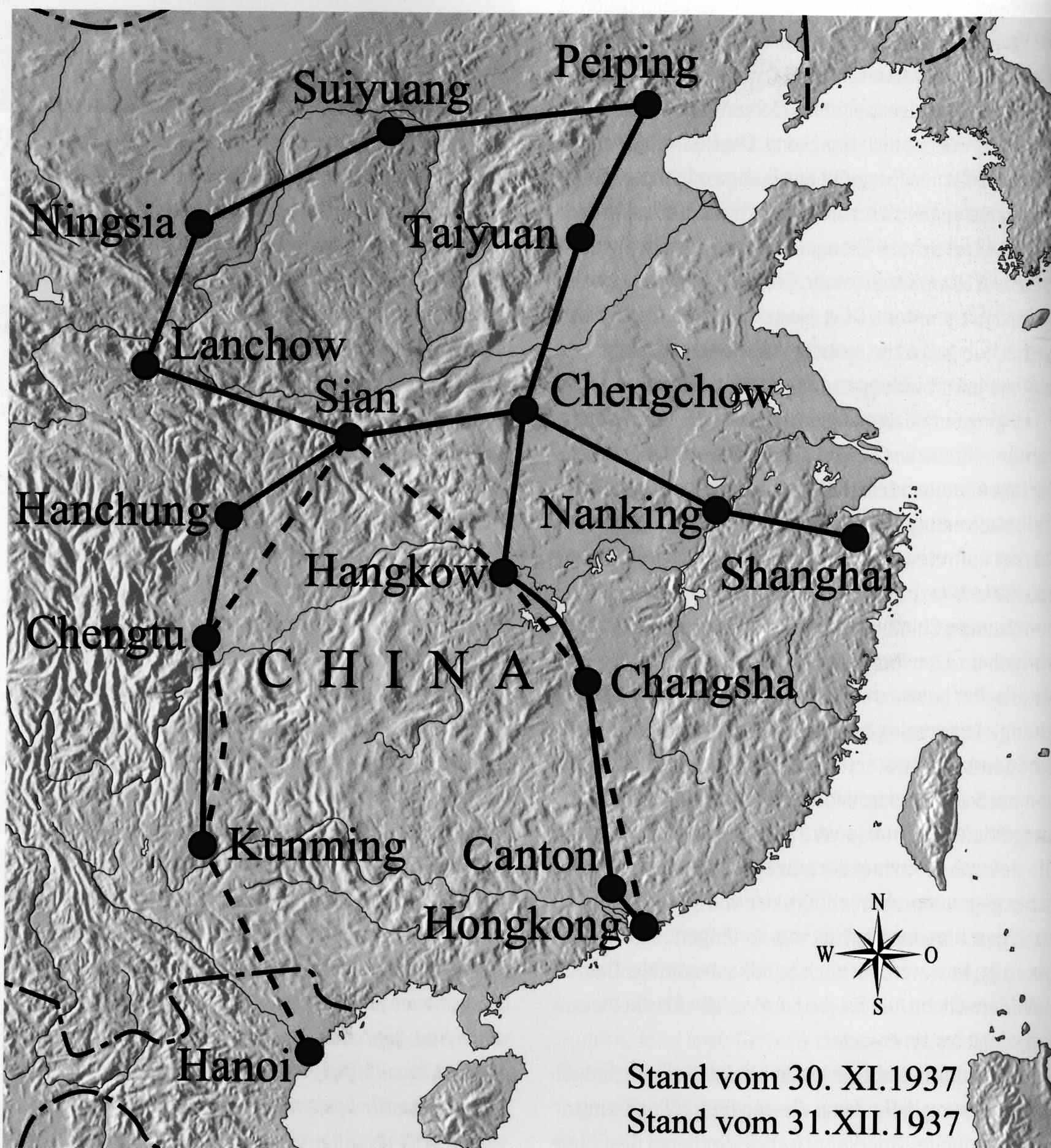
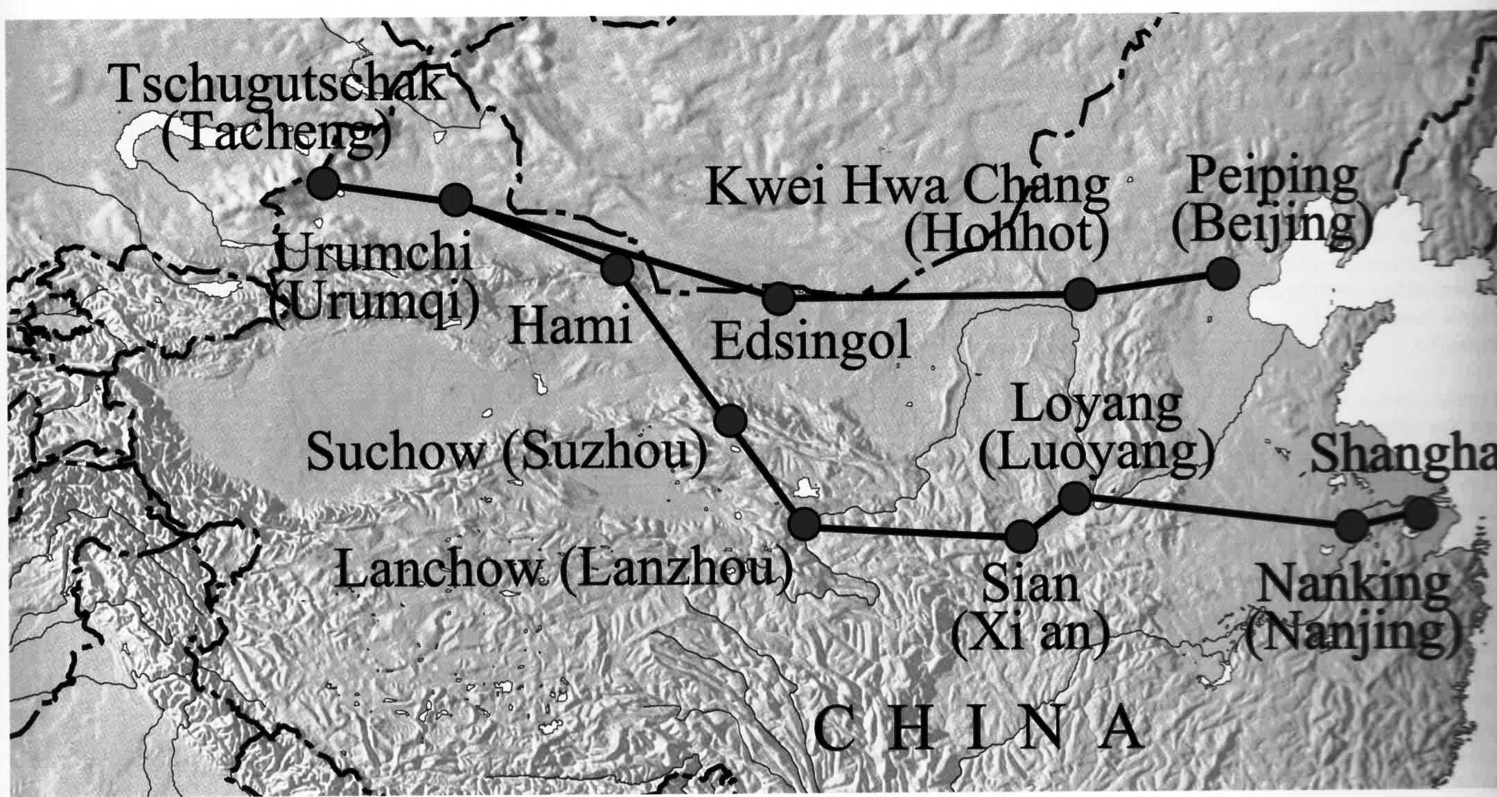
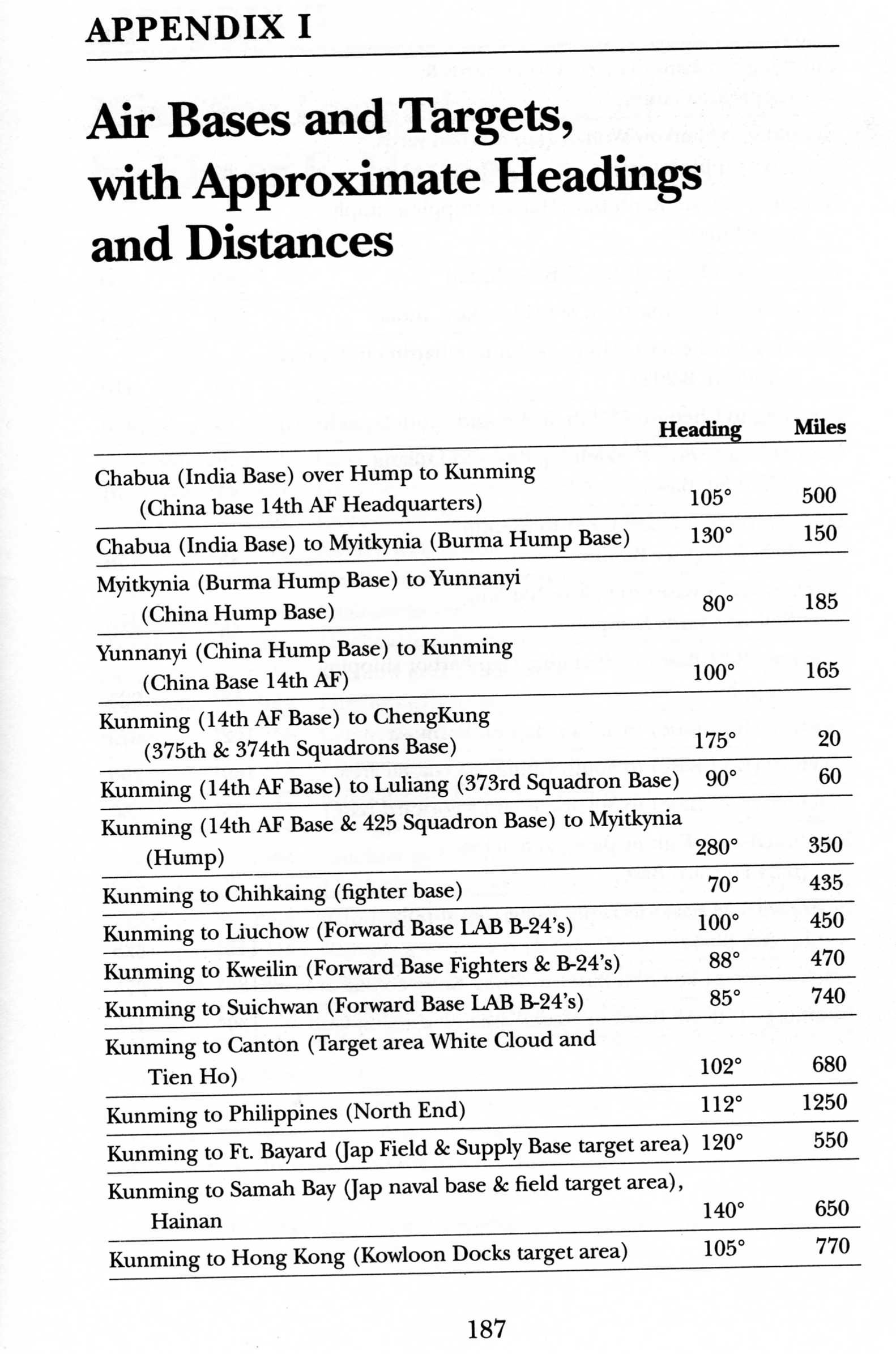
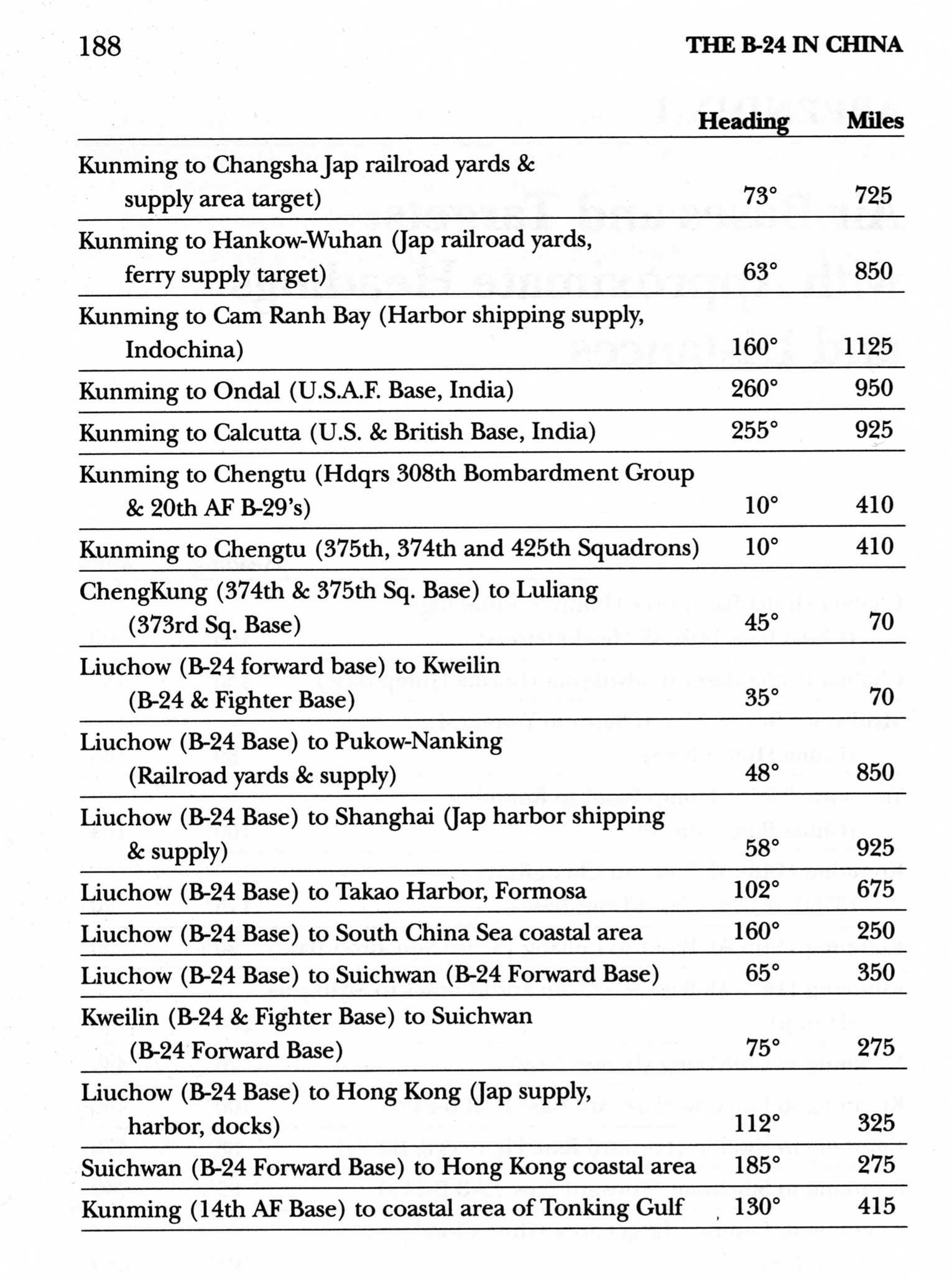
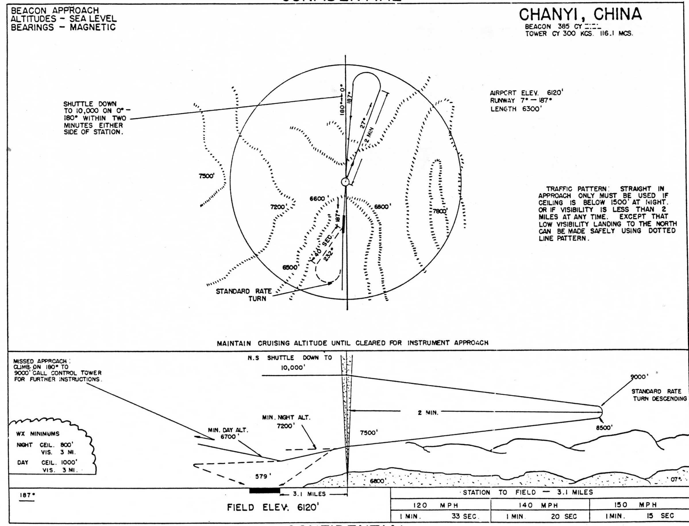
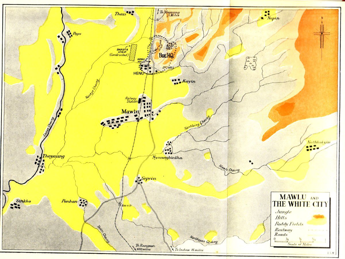
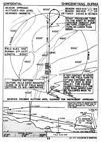
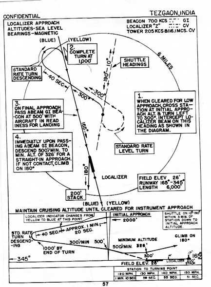
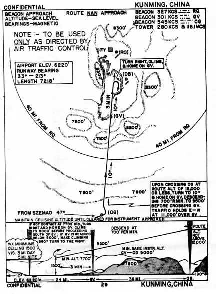
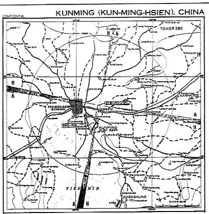
Included Maps show general airfield routes in India, the CBI USAAF assigned Route structures. A few genuine USAAF Approach chart diagrams are included for those interested. Other maps show China airfields and associated information, together with related Operations. There were some minor differences in USAAF Route Station naming, runways and Idents due system changes from 1942-45.
Flight Simulator's geographic positions in this area - although more accurate than Fs9's – still do not co-relate accurately with Real World or GoogleEarth's satellite depictions, and some compromises were required to fit with FSX.
It is possible to fly in FSX from Jansi, well West of Karachi, through India, Burma and to the China coast behind Japanese lines. North as far as Urumchi, South to Ceylon, Lower Burma and the Andaman Islands groups. The CBI "Hump" Routes, pioneered by CNAC and later expanded by the USAAF, are obviously a major feature.
The Peshawar-Urumchi-Sian route was surveyed by a USAAF B-24 as a possible replacement for the difficult "Hump" route - and rejected - terrain, distance, not normally feasible in a C-47 or C-46. Interesting trip real-time. Russian co-operation was minimal and only 80/87 Avgas was available. Lufthansa's "EurAsia" was very active in W and NW China until 1941.
Also included are the "North Atlantic Ferry" Routes - Dorval, Moncton, Gander, Goose Bay, Bluie West One, Stornoway, and Lagens. These are Radio Range routes.
The sceneries were created with ScruffyDuck's "ADEX" as a base for further work and the usual restrictions apply. Errors, where present, are all my own work.
Alex D. NICOLSON
Free for all simmers · 44.52 MB · Scanned clean Jul 2026
Download speed: Free tier is capped at 0.5 Mbps (this file takes approximately 12 mins at the cap). PRO members download at full line speed.
FSX\Addon Scenery\ containing scenery and texture sub-folders.readme.txt or README file. It tells you exactly where files go, what dependencies are needed, and any quirks specific to this add-on.The archive cbix.zip has 702 files and directories contained within it.
This list displays the first 500 files in the package. If the package has more, you will need to download it to view them.
| Filename/Directory | File Date | File Size |
|---|---|---|
| CBIX | 04.22.09 | 0 B |
| Approach Charts | 04.22.09 | 0 B |
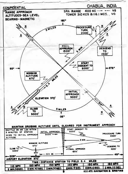
| Chabua.jpg | 12.22.07 | 39.85 kB |
| Chanyi IAP002.jpg | 08.20.08 | 249.18 kB |
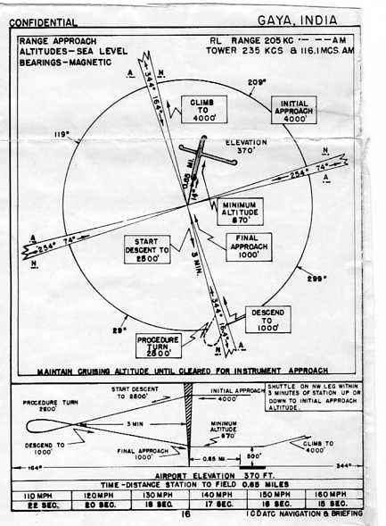
| Gaya.jpg | 12.22.07 | 39.06 kB |
| Jorhat.jpg | 12.22.07 | 33.48 kB |
| Karachi.jpg | 12.22.07 | 36.92 kB |
| Kunming Beacon.JPG | 12.22.07 | 719.19 kB |
| Kunming Pre Range.jpg | 12.22.07 | 45.27 kB |
| Kunming Range.JPG | 12.22.07 | 159.09 kB |
| Kurmitola.jpg | 12.22.07 | 39.06 kB |
| Lalmanir Hat.jpg | 12.22.07 | 38.94 kB |
| Luliang.jpg | 12.22.07 | 50.65 kB |
| Misamari.jpg | 12.22.07 | 34.03 kB |
| Mohanbari.jpg | 12.22.07 | 32.24 kB |
| Myitkyina South.jpg | 12.22.07 | 34.86 kB |
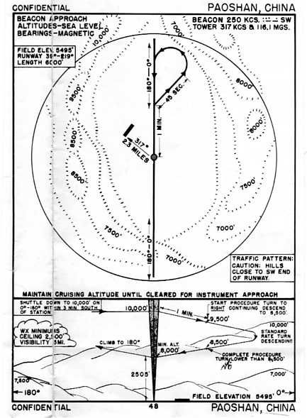
| Paoshan.jpg | 12.22.07 | 41.18 kB |
| Shamshernagar.jpg | 12.22.07 | 36.94 kB |
| Shingbwiyang.jpg | 01.03.08 | 48.92 kB |
| Sookerating.jpg | 12.22.07 | 33.74 kB |
| Tezgaon.jpg | 12.22.07 | 45.63 kB |
| Tezpur.jpg | 12.22.07 | 37.01 kB |
| Warazup.jpg | 12.22.07 | 39.10 kB |
| CBIX Installation.txt | 01.15.11 | 1.06 kB |
| CBIX Readme First.txt | 01.15.11 | 4.49 kB |
| Docs | 04.22.09 | 0 B |
| CBIX Airfields.doc | 01.15.11 | 393.00 kB |
| CBIX Airfields.odt | 01.15.11 | 60.00 kB |
| CBIX Airfields.pdf | 01.15.11 | 152.42 kB |
| CBIX Installation.txt | 01.15.11 | 1.06 kB |
| CBIX Readme First.doc | 01.15.11 | 32.00 kB |
| CBIX Readme First.txt | 01.15.11 | 4.49 kB |
| File_id.diz | 01.15.11 | 102 B |
| Maps | 04.22.09 | 0 B |
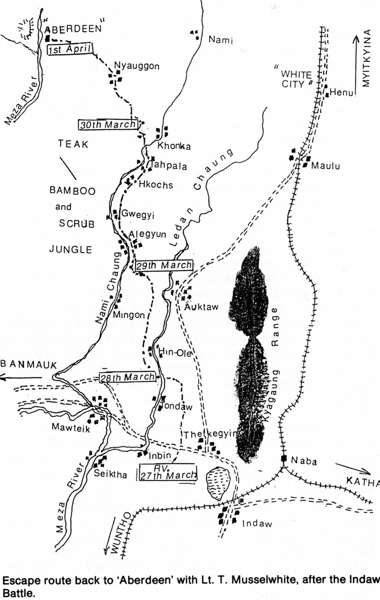
| 2nd Chindit expedition.jpg | 09.03.08 | 138.21 kB |
| Aberdeen.jpg | 01.28.08 | 250.27 kB |
| Aberdeen2.jpg | 01.28.08 | 156.27 kB |
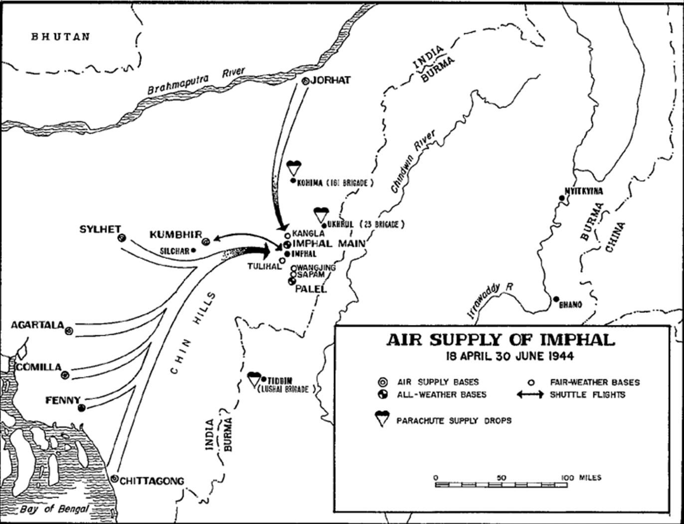
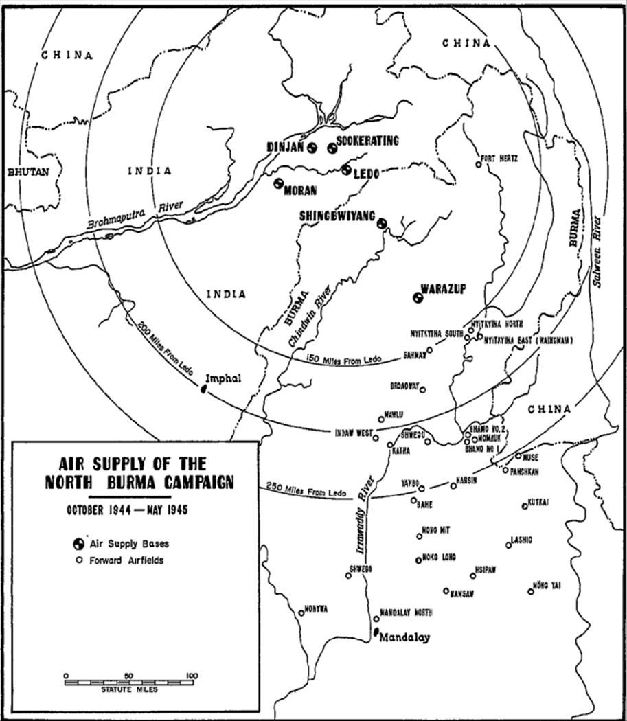
| Air Supply of Imphal.JPG | 11.23.09 | 131.08 kB |
| Air Supply of the N Burma Campaign.JPG | 11.23.09 | 112.42 kB |
| Airfields in Eastern China.jpg | 01.14.11 | 5.32 MB |
| Airfields in Western China.jpg | 12.05.10 | 803.00 kB |
| Assam Bengal China.jpg | 01.13.11 | 4.09 MB |
| Broadway.gif | 01.14.11 | 411.67 kB |
| Burma 1945.jpg | 01.14.11 | 1.52 MB |
| Burma001.jpg | 01.14.11 | 2.22 MB |
| CBI Transportation India China.jpg | 07.15.10 | 99.67 kB |
| CBI-Mileage-Chart.jpg | 01.14.11 | 117.33 kB |
| China 1942-45002.gif | 01.14.11 | 719.44 kB |
| China Airfields.gif | 01.13.11 | 186.62 kB |
| China Airlines 1937.jpg | 01.13.11 | 173.67 kB |
| China Railway.gif | 01.13.11 | 34.85 kB |
| China map.JPG | 01.13.11 | 647.08 kB |
| China reference.jpg | 01.13.11 | 311.06 kB |
| Chindit Area.jpg | 01.14.11 | 182.17 kB |
| EurAsia1.jpg | 01.13.11 | 308.34 kB |
| EurAsia2.jpg | 01.13.11 | 274.50 kB |
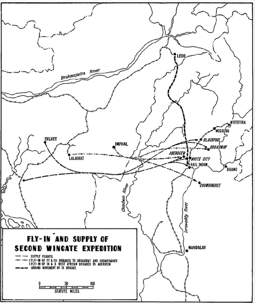
| Fly-in and Supply 2nd Wingate expedition.JPG | 11.23.09 | 102.22 kB |
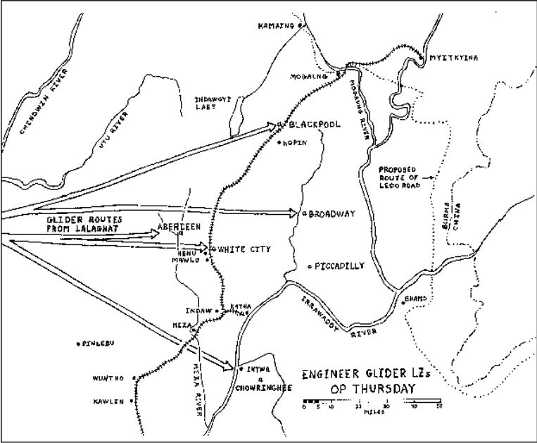
| Gliders snatched Lalaghat for Aberdeen.jpg | 10.05.09 | 14.02 kB |
| Hanoi 1943.gif | 01.13.11 | 344.20 kB |
| Hump Overview.jpg | 01.13.11 | 2.66 MB |
| Hump Route Guide.jpg | 01.13.11 | 3.64 MB |
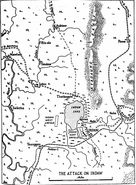
| Indaw airstrips.gif | 01.14.11 | 133.11 kB |
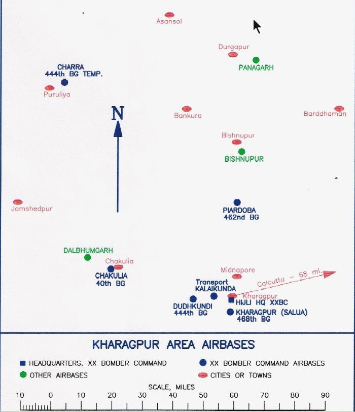
| Kharagpur airbases.gif | 01.13.11 | 95.97 kB |
| Kunming PreRange IAP.jpg | 01.13.11 | 46.91 kB |
| Mt Tali CBIX.JPG | 08.17.08 | 49.05 kB |
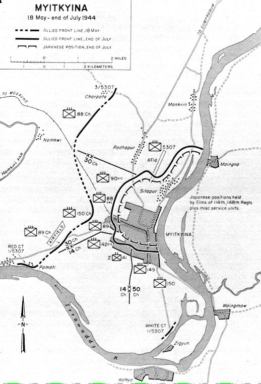
| Myitkyina airfields.jpg | 01.13.11 | 319.30 kB |
| Route Charlie.jpg | 01.13.11 | 2.70 MB |
| Route Easy.jpg | 01.13.11 | 2.51 MB |
| Route Fox.jpg | 01.13.11 | 2.09 MB |
| Route Nan.jpg | 01.13.11 | 2.28 MB |
| Route One Love King.gif | 01.13.11 | 2.19 MB |
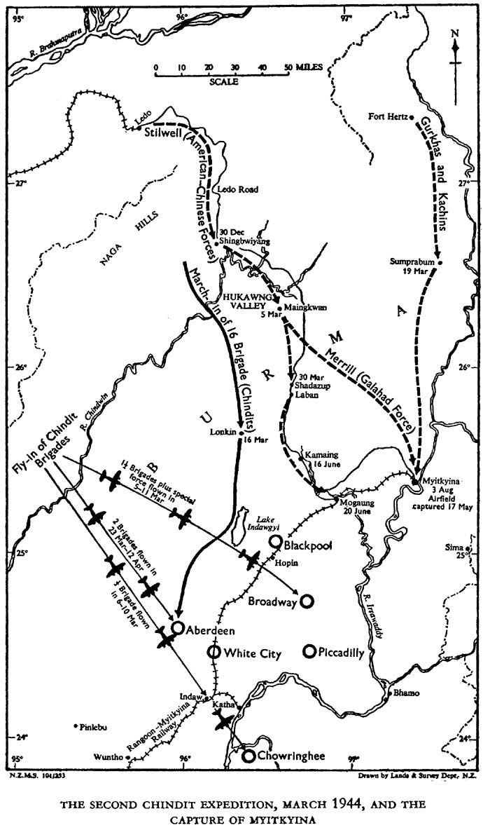
| The Chindit Expeditions001.jpg | 01.14.11 | 1.68 MB |
| The Imphal Battle001.jpg | 01.14.11 | 1.76 MB |
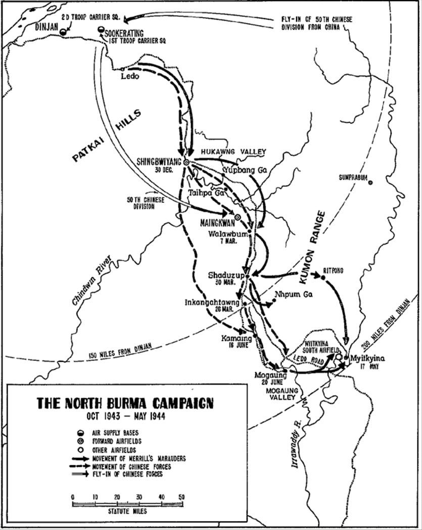
| The North Burma Campaign.JPG | 11.23.09 | 106.55 kB |
| USAAF B-24 Air Bases hdgs and Distances.jpg | 03.22.08 | 236.23 kB |
| USAAF B-24 Air Bases hdgs and Distances1.jpg | 03.22.08 | 248.78 kB |
| White City.jpg | 10.04.10 | 307.88 kB |
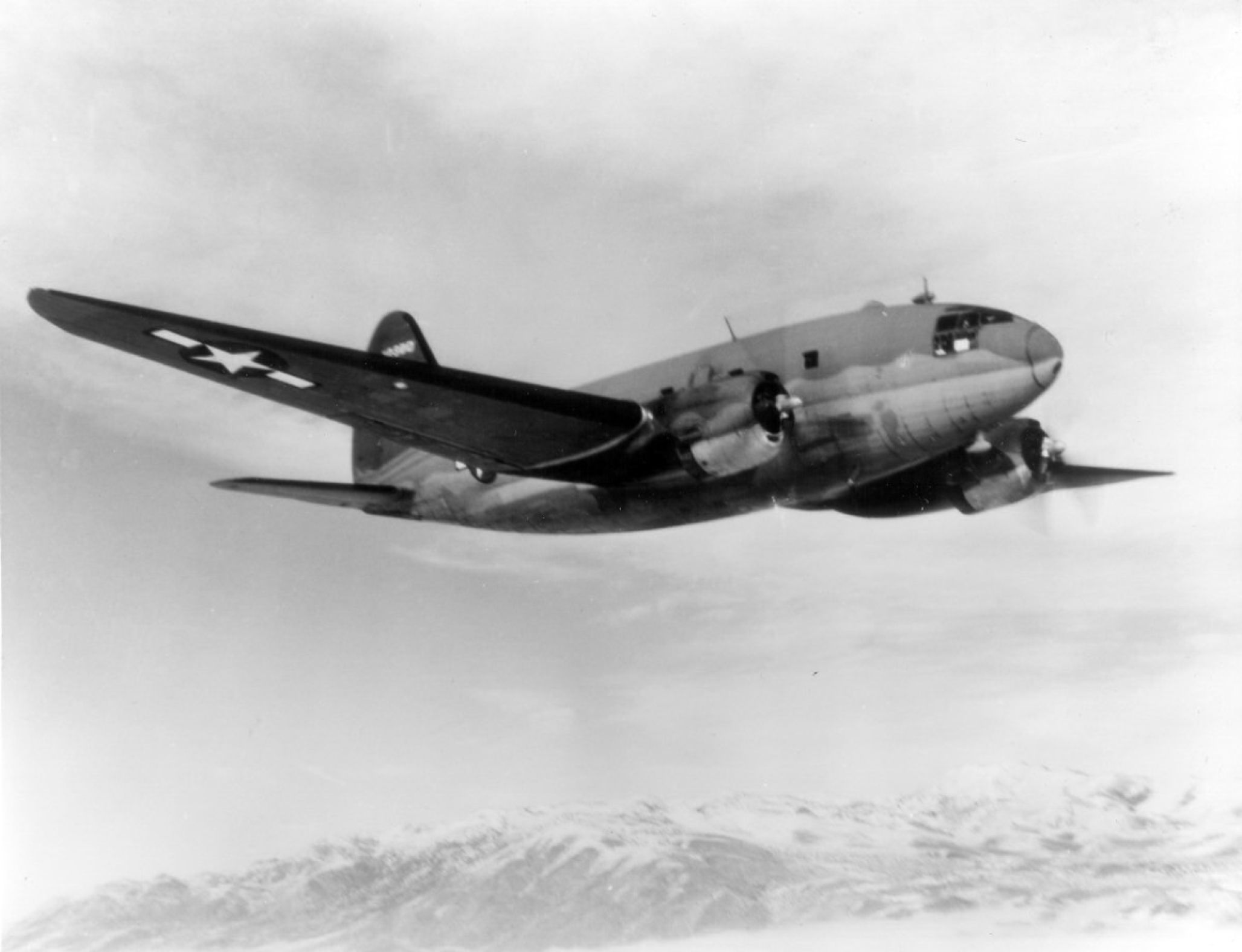
| usaf_c-46_02.jpg | 01.14.11 | 702.49 kB |
| scenery | 04.22.09 | 0 B |
| 'Aberdeen' Burma CAB_ADEX_ADN.BGL | 01.04.11 | 1.49 kB |
| 'Aberdeen' Burma CAB_ADEX_ADN_CVX.bgl | 01.04.11 | 607 B |
| 'Blackpool' Burma CBL_ADEX_ADN.BGL | 01.04.11 | 2.81 kB |
| 'Blackpool' Burma CBL_ADEX_ADN_CVX.bgl | 01.04.11 | 814 B |
| 'Broadway' Burma CBW_ADEX_ADN.BGL | 01.04.11 | 3.39 kB |
| 'Broadway' Burma CBW_ADEX_ADN_CVX.bgl | 01.04.11 | 1.47 kB |
| 'Chowringhee' airstrip Burma CHW_ADEX_ADN.BGL | 01.05.11 | 1.16 kB |
| 'Chowringhee' airstrip Burma CHW_ADEX_ADN_CVX.bgl | 01.05.11 | 228 B |
| 'Highland Queen' Burma HB_ADEX_ADN.BGL | 01.08.11 | 1.06 kB |
| 'Highland Queen' Burma HB_ADEX_ADN_CVX.bgl | 01.08.11 | 243 B |
| 'Indaw Lake East' Burma CIE_ADEX_ADN.BGL | 01.05.11 | 1.06 kB |
| 'Indaw Lake East' Burma CIE_ADEX_ADN_CVX.bgl | 01.05.11 | 241 B |
| 'Indaw Lake West' Burma CIW_ADEX_ADN.BGL | 01.05.11 | 1.00 kB |
| 'Indaw Lake West' Burma CIW_ADEX_ADN_CVX.bgl | 01.05.11 | 243 B |
| 'John Haig' Burma JH_ADEX_ADN.BGL | 01.08.11 | 884 B |
| 'John Haig' Burma JH_ADEX_ADN_CVX.bgl | 01.08.11 | 396 B |
| 'Johnnie Walker' Burma JW_ADEX_ADN.BGL | 01.08.11 | 957 B |
| 'Johnnie Walker' Burma JW_ADEX_ADN_CVX.bgl | 01.08.11 | 236 B |
| 'White City' Burma CWC_ADEX_ADN.BGL | 01.05.11 | 2.29 kB |
| 'White City' Burma CWC_ADEX_ADN_CVX.bgl | 01.05.11 | 255 B |
| Agartala India UN_ADEX_ADN.BGL | 12.30.10 | 38.53 kB |
| Agartala India UN_ADEX_ADN_CVX.bgl | 12.30.10 | 510 B |
| Agra India YG_ADEX_ADN.BGL | 12.30.10 | 15.09 kB |
| Agra India YG_ADEX_ADN_CVX.bgl | 12.30.10 | 258 B |
| Akyab Burma AK_ADEX_ADN.BGL | 01.03.11 | 2.44 kB |
| Akyab Burma AK_ADEX_ADN_CVX.bgl | 01.03.11 | 362 B |
| Alipore India AL_ADEX_ADN.BGL | 12.30.10 | 4.54 kB |
| Alipore India AL_ADEX_ADN_CVX.bgl | 12.30.10 | 243 B |
| Allahabad India LL_ADEX_ADN.BGL | 12.30.10 | 4.54 kB |
| Allahabad India LL_ADEX_ADN_CVX.bgl | 12.30.10 | 243 B |
| AnShun China AH_ADEX_ADN.BGL | 12.22.10 | 3.86 kB |
| AnShun China AH_ADEX_ADN_CVX.bgl | 12.22.10 | 392 B |
| Aniksakan Burma CZ_ADEX_ADN.BGL | 01.04.11 | 1.22 kB |
| Aniksakan Burma CZ_ADEX_ADN_CVX.bgl | 01.04.11 | 619 B |
| Ankang China PR_ADEX_ADN.BGL | 12.22.10 | 2.05 kB |
| Ankang China PR_ADEX_ADN_CVX.bgl | 12.22.10 | 254 B |
| Asansol India AS_ADEX_ADN.BGL | 12.30.10 | 5.06 kB |
| Asansol India AS_ADEX_ADN_CVX.bgl | 12.30.10 | 444 B |
| Bangalore India BO_ADEX_ADN.BGL | 12.30.10 | 4.64 kB |
| Bangalore India BO_ADEX_ADN_CVX.bgl | 12.30.10 | 347 B |
| Barrackpore India CM_ADEX_ADN.BGL | 12.30.10 | 4.51 kB |
| Barrackpore India CM_ADEX_ADN_CVX.bgl | 12.30.10 | 594 B |
| Bassein Burma PN_ADEX_ADN.BGL | 01.04.11 | 1.09 kB |
| Bassein Burma PN_ADEX_ADN_CVX.bgl | 01.04.11 | 474 B |
| Bhamo No2 Burma CN_ADEX_ADN.BGL | 01.04.11 | 4.64 kB |
| Bhamo No2 Burma CN_ADEX_ADN_CVX.bgl | 01.04.11 | 316 B |
| Bombay India BB_ADEX_ADN.BGL | 12.30.10 | 6.62 kB |
| Bombay India BB_ADEX_ADN_CVX.bgl | 12.30.10 | 418 B |
| Calcutta India EA_ADEX_ADN.BGL | 12.31.10 | 5.43 kB |
| Calcutta India EA_ADEX_ADN_CVX.bgl | 12.31.10 | 675 B |
| Cawnpore India CW_ADEX_ADN.BGL | 12.30.10 | 5.62 kB |
| Cawnpore India CW_ADEX_ADN_CVX.bgl | 12.30.10 | 340 B |
| Ch'ang-T'ing China CX_ADEX_ADN.BGL | 12.22.10 | 2.40 kB |
| Ch'ang-T'ing China CX_ADEX_ADN_CVX.bgl | 12.22.10 | 340 B |
| Chabua India VG_ADEX_ADN.BGL | 12.31.10 | 26.24 kB |
| Chabua India VG_ADEX_ADN_CVX.bgl | 12.31.10 | 618 B |
| Chaklala India CK_ADEX_ADN.BGL | 12.22.10 | 4.28 kB |
| Chaklala India CK_ADEX_ADN_CVX.bgl | 12.22.10 | 243 B |
| Chakulia India CL_ADEX_ADN.BGL | 12.31.10 | 39.32 kB |
| Chakulia India CL_ADEX_ADN_CVX.bgl | 12.31.10 | 405 B |
| Changsha China CA_ADEX_ADN.BGL | 12.22.10 | 3.52 kB |
| Changsha China CA_ADEX_ADN_CVX.bgl | 12.22.10 | 243 B |
| Chanyi China CY_ADEX_ADN.BGL | 12.22.10 | 11.82 kB |
| Chanyi China CY_ADEX_ADN_CVX.bgl | 12.22.10 | 484 B |
| Chaotung China CT_ADEX_ADN.BGL | 12.22.10 | 2.81 kB |
| Chaotung China CT_ADEX_ADN_CVX.bgl | 12.22.10 | 355 B |
| Charra India KL_ADEX_ADN.BGL | 12.31.10 | 14.86 kB |
| Charra India KL_ADEX_ADN_CVX.bgl | 12.31.10 | 251 B |
| Chaukan Pass India CQ_ADEX_ADN.BGL | 12.31.10 | 1.91 kB |
| Chaukan Pass India CQ_ADEX_ADN_CVX.bgl | 12.31.10 | 340 B |
| Chengkung China DB_ADEX_ADN.BGL | 12.22.10 | 14.10 kB |
| Chengkung China DB_ADEX_ADN_CVX.bgl | 12.22.10 | 281 B |
| Chengtu ShwangLui China SG_ADEX_ADN.BGL | 12.22.10 | 1.46 kB |
| Chengtu ShwangLui China SG_ADEX_ADN_CVX.bgl | 12.22.10 | 380 B |
| Chi-an China KN_ADEX_ADN.BGL | 12.22.10 | 1.86 kB |
| Chi-an China KN_ADEX_ADN_CVX.bgl | 12.22.10 | 358 B |
| Chien-Yang China CF_ADEX_ADN.BGL | 12.22.10 | 3.84 kB |
| Chien-Yang China CF_ADEX_ADN_CVX.bgl | 12.22.10 | 236 B |
| Chih Hu Lake Homer China CG_ADEX_ADN.BGL | 12.22.10 | 692 B |
| Chihkiang China KA_ADEX_ADN.BGL | 12.22.10 | 2.96 kB |
| Chihkiang China KA_ADEX_ADN_CVX.bgl | 12.22.10 | 396 B |
| China Bay Ceylon TR_ADEX_ADN.BGL | 12.31.10 | 4.03 kB |
| China Bay Ceylon TR_ADEX_ADN_CVX.bgl | 12.31.10 | 258 B |
| ChingCheng China TE_ADEX_ADN.BGL | 12.23.10 | 3.37 kB |
| ChingCheng China TE_ADEX_ADN_CVX.bgl | 12.23.10 | 450 B |
| ChioLongPo China PK_ADEX_ADN.BGL | 12.23.10 | 3.05 kB |
| ChioLongPo China PK_ADEX_ADN_CVX.bgl | 12.23.10 | 258 B |
| Chiringa India CI_ADEX_ADN.BGL | 12.31.10 | 3.31 kB |
| Chiringa India CI_ADEX_ADN_CVX.bgl | 12.31.10 | 351 B |
| Chittagong India NR_ADEX_ADN.BGL | 12.31.10 | 5.35 kB |
| Chittagong India NR_ADEX_ADN_CVX.bgl | 12.31.10 | 451 B |
| Chiu-Chou China XI_ADEX_ADN.BGL | 12.23.10 | 2.57 kB |
| Chiu-Chou China XI_ADEX_ADN_CVX.bgl | 12.23.10 | 351 B |
| Chungtien China XC_ADEX_ADN.BGL | 12.23.10 | 1.23 kB |
| Chungtien China XC_ADEX_ADN_CVX.bgl | 12.23.10 | 344 B |
| Cochin India CC_ADEX_ADN.BGL | 12.31.10 | 3.33 kB |
| Cochin India CC_ADEX_ADN_CVX.bgl | 12.31.10 | 355 B |
| Coco Island Burma CS_ADEX_ADN.BGL | 01.05.11 | 1014 B |
| Coco Island Burma CS_ADEX_ADN_CVX.bgl | 01.05.11 | 241 B |
| Colombo Ceylon RT_ADEX_ADN.BGL | 12.31.10 | 3.78 kB |
| Colombo Ceylon RT_ADEX_ADN_CVX.bgl | 12.31.10 | 363 B |
| Comilla India RA_ADEX_ADN.BGL | 12.31.10 | 4.98 kB |
| Comilla India RA_ADEX_ADN_CVX.bgl | 12.31.10 | 341 B |
| Cox's Bazaar India AX_ADEX_ADN.BGL | 12.31.10 | 2.75 kB |
| Cox's Bazaar India AX_ADEX_ADN_CVX.bgl | 12.31.10 | 826 B |
| Dergaon India QZ_ADEX_ADN.BGL | 01.03.11 | 4.79 kB |
| Dergaon India QZ_ADEX_ADN_CVX.bgl | 01.03.11 | 1.00 kB |
| Dhalbumgarh India DU_ADEX_ADN.BGL | 12.31.10 | 13.61 kB |
| Dhalbumgarh India DU_ADEX_ADN_CVX.bgl | 12.31.10 | 453 B |
| Dhubalia India DL_ADEX_ADN.BGL | 12.31.10 | 19.75 kB |
| Dhubalia India DL_ADEX_ADN_CVX.bgl | 12.31.10 | 459 B |
| Digri India DG_ADEX_ADN.BGL | 12.31.10 | 12.85 kB |
| Digri India DG_ADEX_ADN_CVX.bgl | 12.31.10 | 544 B |
| Dinjan India RH_ADEX_ADN.BGL | 12.31.10 | 30.40 kB |
| Dinjan India RH_ADEX_ADN_CVX.bgl | 12.31.10 | 470 B |
| Dorval RadioRange Canada ULR_ADEX_ADN.BGL | 01.09.11 | 1005 B |
| Dorval RadioRange Canada ULR_ADEX_ADN_CVX.bgl | 01.09.11 | 416 B |
| Dudhkundi India DK_ADEX_ADN.BGL | 01.01.11 | 43.19 kB |
| Dudhkundi India DK_ADEX_ADN_CVX.bgl | 01.01.11 | 849 B |
| Edsingol China ED_ADEX_ADN.BGL | 12.22.10 | 1.41 kB |
| Edsingol China ED_ADEX_ADN_CVX.bgl | 12.22.10 | 388 B |
| Enshih China SH_ADEX_ADN.BGL | 12.22.10 | 3.59 kB |
| Enshih China SH_ADEX_ADN_CVX.bgl | 12.22.10 | 241 B |
| Feng-Fu No2 China FF_ADEX_ADN.BGL | 12.23.10 | 2.67 kB |
| Feng-Fu No2 China FF_ADEX_ADN_CVX.bgl | 12.23.10 | 332 B |
| FengHuangShan China FH_ADEX_ADN.BGL | 12.23.10 | 1.70 kB |
| FengHuangShan China FH_ADEX_ADN_CVX.bgl | 12.23.10 | 340 B |
| Fenny India KK_ADEX_ADN.BGL | 01.01.11 | 6.57 kB |
| Fenny India KK_ADEX_ADN_CVX.bgl | 01.01.11 | 351 B |
| Fort Harrison Burma FHR_ADEX_ADN_CVX.BGL | 01.05.11 | 1.03 kB |
| Fort Harrison Burma FHR_ADEX_ADN_CVX_CVX.bgl | 01.05.11 | 236 B |
| Ft Hertz DH_ADEX_ADN.BGL | 01.05.11 | 5.30 kB |
| Ft Hertz DH_ADEX_ADN_CVX.bgl | 01.05.11 | 394 B |
| Gander RadioRange Canada QXR_ADEX_ADN.BGL | 01.10.11 | 1002 B |
| Gander RadioRange Canada QXR_ADEX_ADN_CVX.bgl | 01.10.11 | 332 B |
| Gaya India AM_ADEX_ADN.BGL | 01.01.11 | 8.98 kB |
| Gaya India AM_ADEX_ADN_CVX.bgl | 01.01.11 | 831 B |
| Golaghat India EL_ADEX_ADN.BGL | 01.01.11 | 5.39 kB |
| Golaghat India EL_ADEX_ADN_CVX.bgl | 01.01.11 | 359 B |
| Goose Bay RadioRange Canada YRR_ADEX_ADN.BGL | 01.10.11 | 1017 B |
| Goose Bay RadioRange Canada YRR_ADEX_ADN_CVX.bgl | 01.10.11 | 332 B |
| Gushkara India GH_ADEX_ADN.BGL | 01.01.11 | 5.30 kB |
| Gushkara India GH_ADEX_ADN_CVX.bgl | 01.01.11 | 343 B |
| Hailakandi India HL_ADEX_ADN.BGL | 01.01.11 | 3.34 kB |
| Hailakandi India HL_ADEX_ADN_CVX.bgl | 01.01.11 | 343 B |
| Hakimpet India HK_ADEX_ADN.BGL | 01.01.11 | 4.70 kB |
| Hakimpet India HK_ADEX_ADN_CVX.bgl | 01.01.11 | 347 B |
| Hami China HM_ADEX_ADN.BGL | 12.22.10 | 2.77 kB |
| Hami China HM_ADEX_ADN_CVX.bgl | 12.22.10 | 347 B |
| HanChung China HA_ADEX_ADN.BGL | 12.22.10 | 2.76 kB |
| HanChung China HA_ADEX_ADN_CVX.bgl | 12.22.10 | 347 B |
| Hanoi Indo-China HO_ADEX_ADN.BGL | 12.22.10 | 5.30 kB |
| Hanoi Indo-China HO_ADEX_ADN_CVX.bgl | 12.22.10 | 425 B |
| Hathazari India HH_ADEX_ADN.BGL | 01.01.11 | 1.98 kB |
| Hathazari India HH_ADEX_ADN_CVX.bgl | 01.01.11 | 332 B |
| HeHo Burma HE_ADEX_ADN.BGL | 01.05.11 | 1.10 kB |
| HeHo Burma HE_ADEX_ADN_CVX.bgl | 01.05.11 | 908 B |
| HengYang China HY_ADEX_ADN.BGL | 12.22.10 | 2.92 kB |
| HengYang China HY_ADEX_ADN_CVX.bgl | 12.22.10 | 232 B |
| Hohhot-SuiYuan China IH_ADEX_ADN.BGL | 12.24.10 | 1.37 kB |
| Hohhot-SuiYuan China IH_ADEX_ADN_CVX.bgl | 12.24.10 | 362 B |
| Honolulu HI HNLR_ADEX_ADN.BGL | 12.22.10 | 1019 B |
| Honolulu HI HNLR_ADEX_ADN_CVX.bgl | 12.22.10 | 332 B |
| Hsamshingyang Burma HS_ADEX_ADN.BGL | 01.05.11 | 1.48 kB |
| Hsamshingyang Burma HS_ADEX_ADN_CVX.bgl | 01.05.11 | 243 B |
| Hsi Chiang China LB_ADEX_ADN.BGL | 12.24.10 | 4.51 kB |
| Hsi Chiang China LB_ADEX_ADN_CVX.bgl | 12.24.10 | 605 B |
| Hsin-Ch'eng China SC_ADEX_ADN.BGL | 12.24.10 | 4.82 kB |
| Hsin-Ch'eng China SC_ADEX_ADN_CVX.bgl | 12.24.10 | 621 B |
| Hsinching A-1 China CU_ADEX_ADN.BGL | 12.24.10 | 31.83 kB |
| Hsinching A-1 China CU_ADEX_ADN_CVX.bgl | 12.24.10 | 873 B |
| Hsining China HX_ADEX_ADN.BGL | 12.24.10 | 2.95 kB |
| Hsining China HX_ADEX_ADN_CVX.bgl | 12.24.10 | 347 B |
| Hsiu-Shan China HN_ADEX_ADN.BGL | 12.24.10 | 3.58 kB |
| Hsiu-Shan China HN_ADEX_ADN_CVX.bgl | 12.24.10 | 347 B |
| Hsun-tien China HT_ADEX_ADN.BGL | 12.24.10 | 3.00 kB |
| Hsun-tien China HT_ADEX_ADN_CVX.bgl | 12.24.10 | 332 B |
| Imphal Tulihal India OM_ADEX_ADN.BGL | 01.01.11 | 5.63 kB |
| Imphal Tulihal India OM_ADEX_ADN_CVX.bgl | 01.01.11 | 602 B |
| Indainggale Burma HW_ADEX_ADN.BGL | 01.05.11 | 1.86 kB |
| Indainggale Burma HW_ADEX_ADN_CVX.bgl | 01.05.11 | 394 B |
| Ipin China VM_ADEX_ADN.BGL | 12.24.10 | 2.40 kB |
| Ipin China VM_ADEX_ADN_CVX.bgl | 12.24.10 | 385 B |
| Jessore India ZN_ADEX_ADN.BGL | 01.01.11 | 5.36 kB |
| Jessore India ZN_ADEX_ADN_CVX.bgl | 01.01.11 | 347 B |
| Jiwani India JI_ADEX_ADN.BGL | 01.01.11 | 4.16 kB |
| Jiwani India JI_ADEX_ADN_CVX.bgl | 01.01.11 | 340 B |
| Jodhpur India JP_ADEX_ADN.BGL | 01.01.11 | 5.33 kB |
| Jodhpur India JP_ADEX_ADN_CVX.bgl | 01.01.11 | 340 B |
| Jorhat India PW_ADEX_ADN.BGL | 01.01.11 | 6.45 kB |
| Jorhat India PW_ADEX_ADN_CVX.bgl | 01.01.11 | 698 B |
| Kalaikunda India KU_ADEX_ADN.BGL | 01.01.11 | 15.76 kB |
| Kalaikunda India KU_ADEX_ADN.BGL.old | 12.22.10 | 8.84 kB |
| Kalaikunda India KU_ADEX_ADN_CVX.bgl | 01.01.11 | 654 B |
| Kalaikunda India KU_ADEX_ADN_CVX.bgl.old | 12.22.10 | 595 B |
| Kanchow China KC_ADEX_ADN.BGL | 12.22.10 | 3.51 kB |
| Kanchow China KC_ADEX_ADN_CVX.bgl | 12.22.10 | 416 B |
| Kantzu Tibet TK_ADEX_ADN.BGL | 01.06.11 | 2.40 kB |
| Kantzu Tibet TK_ADEX_ADN_CVX.bgl | 01.06.11 | 332 B |
| Karachi India RY_ADEX_ADN.BGL | 01.02.11 | 5.18 kB |
| Karachi India RY_ADEX_ADN_CVX.bgl | 01.02.11 | 610 B |
| Katha Burma KQ_ADEX_ADN.BGL | 01.05.11 | 1.15 kB |
| Katha Burma KQ_ADEX_ADN_CVX.bgl | 01.05.11 | 383 B |
| Kharagpur India KH_ADEX_ADN_CVX.bgl | 01.02.11 | 477 B |
| KiangTsing China KS_ADEX_ADN.BGL | 12.22.10 | 2.60 kB |
| KiangTsing China KS_ADEX_ADN_CVX.bgl | 12.22.10 | 243 B |
| Kienow China KO_ADEX_ADN.BGL | 12.24.10 | 2.50 kB |
| Kienow China KO_ADEX_ADN_CVX.bgl | 12.24.10 | 347 B |
| Kiunglai A-5 China OD_ADEX_ADN.BGL | 12.24.10 | 8.38 kB |
| Kiunglai A-5 China OD_ADEX_ADN_CVX.bgl | 12.24.10 | 445 B |
| Koirengai India KR_ADEX_ADN.BGL | 01.02.11 | 1.52 kB |
| Koirengai India KR_ADEX_ADN_CVX.bgl | 01.02.11 | 332 B |
| Kuang-Ch'ang New China GN_ADEX_ADN.BGL | 12.24.10 | 2.25 kB |
| Kuang-Ch'ang New China GN_ADEX_ADN_CVX.bgl | 12.24.10 | 347 B |
| Kuang-Ch'ang Old GO_ADEX_ADN.BGL | 12.22.10 | 1.85 kB |
| Kuang-Ch'ang Old GO_ADEX_ADN_CVX.bgl | 12.22.10 | 340 B |
| Kuang-Yuan New China KX_ADEX_ADN.BGL | 12.22.10 | 2.62 kB |
| Kuang-Yuan New China KX_ADEX_ADN_CVX.bgl | 12.22.10 | 351 B |
| Kunming China RQ_ADEX_ADN.BGL | 12.22.10 | 40.09 kB |
| Kunming China RQ_ADEX_ADN_CVX.bgl | 12.22.10 | 448 B |
| Kunyang Homer China GV_ADEX_ADN.BGL | 12.22.10 | 738 B |
| Kunyang Homer China GV_ADEX_ADN_CVX.bgl | 12.22.10 | 226 B |
| Kurmitola India GI_ADEX_ADN.BGL | 01.02.11 | 5.16 kB |
| Kurmitola India GI_ADEX_ADN_CVX.bgl | 01.02.11 | 355 B |
| Kwanghan A-3 China LK_ADEX_ADN.BGL | 12.25.10 | 9.10 kB |
| Kwanghan A-3 China LK_ADEX_ADN_CVX.bgl | 12.25.10 | 616 B |
| Kweilin-Erhtong China ER_ADEX_ADN.BGL | 12.25.10 | 15.45 kB |
| Kweilin-Erhtong China ER_ADEX_ADN_CVX.bgl | 12.25.10 | 362 B |
| Kweilin-Li Chia Chen China LC_ADEX_ADN.BGL | 12.25.10 | 3.00 kB |
| Kweilin-Li Chia Chen China LC_ADEX_ADN_CVX.bgl | 12.25.10 | 347 B |
| Kweilin-YangTong China YT_ADEX_ADN.BGL | 12.25.10 | 14.94 kB |
| Kweilin-YangTong China YT_ADEX_ADN_CVX.bgl | 12.25.10 | 817 B |
| Kweiyang No1 China KY_ADEX_ADN.BGL | 12.25.10 | 3.95 kB |
| Kweiyang No1 China KY_ADEX_ADN_CVX.bgl | 12.25.10 | 621 B |
| Kweiyang No2 China KZ_ADEX_ADN.BGL | 12.25.10 | 3.48 kB |
| Kweiyang No2 China KZ_ADEX_ADN_CVX.bgl | 12.25.10 | 332 B |
| LPLA_ADEX_ADN.BGL | 12.22.10 | 3.66 kB |
| LPLA_ADEX_ADN_CVX.bgl | 12.22.10 | 276 B |
| Lagens Azores LGR_ADEX_ADN.BGL | 01.14.11 | 6.77 kB |
| Lagens Azores LGR_ADEX_ADN_CVX.bgl | 01.14.11 | 395 B |
| Lahore India LH_ADEX_ADN.BGL | 01.02.11 | 4.99 kB |
| Lahore India LH_ADEX_ADN_CVX.bgl | 01.02.11 | 440 B |
| LaiFeng China LF_ADEX_ADN.BGL | 12.25.10 | 3.66 kB |
| LaiFeng China LF_ADEX_ADN_CVX.bgl | 12.25.10 | 343 B |
| Lalaghat India LG_ADEX_ADN_CVX.BGL | 01.02.11 | 2.15 kB |
| Lalaghat India LG_ADEX_ADN_CVX_CVX.bgl | 01.02.11 | 227 B |
| Lalmanir Hat India XR_ADEX_ADN.BGL | 01.02.11 | 18.25 kB |
| Lalmanir Hat India XR_ADEX_ADN_CVX.bgl | 01.02.11 | 754 B |
| Lanchow China OO_ADEX_ADN.BGL | 12.22.10 | 2.80 kB |
| Lanchow China OO_ADEX_ADN_CVX.bgl | 12.22.10 | 344 B |
| LangChung-Paoning China XE_ADEX_ADN.BGL | 12.26.10 | 3.85 kB |
| LangChung-Paoning China XE_ADEX_ADN_CVX.bgl | 12.26.10 | 344 B |
| LaoHoKou China OG_ADEX_ADN.BGL | 12.26.10 | 4.39 kB |
| LaoHoKou China OG_ADEX_ADN_CVX.bgl | 12.26.10 | 602 B |
| Laowhangpin China LO_ADEX_ADN.BGL | 12.22.10 | 3.64 kB |
| Laowhangpin China LO_ADEX_ADN_CVX.bgl | 12.22.10 | 348 B |
| Lashio Burma FK_ADEX_ADN.BGL | 01.05.11 | 2.48 kB |
| Lashio Burma FK_ADEX_ADN_CVX.bgl | 01.05.11 | 232 B |
| Ledo India ZA_ADEX_ADN.BGL | 01.02.11 | 14.96 kB |
| Ledo India ZA_ADEX_ADN_CVX.bgl | 01.02.11 | 522 B |
| Lewe Burma LE_ADEX_ADN.BGL | 01.05.11 | 1.45 kB |
| Lewe Burma LE_ADEX_ADN_CVX.bgl | 01.05.11 | 236 B |
| Lia-Chia-Tu China LT_ADEX_ADN.BGL | 12.26.10 | 2.20 kB |
| Lia-Chia-Tu China LT_ADEX_ADN_CVX.bgl | 12.26.10 | 602 B |
| Liang-Shan China LM_ADEX_ADN.BGL | 12.26.10 | 3.52 kB |
| Liang-Shan China LM_ADEX_ADN_CVX.bgl | 12.26.10 | 347 B |
| Likiang China DM_ADEX_ADN.BGL | 12.26.10 | 2.40 kB |
| Likiang China DM_ADEX_ADN_CVX.bgl | 12.26.10 | 362 B |
| LingLing China LN_ADEX_ADN.BGL | 12.26.10 | 4.52 kB |
| LingLing China LN_ADEX_ADN_CVX.bgl | 12.26.10 | 332 B |
| Liuchow China OW_ADEX_ADN.BGL | 12.26.10 | 37.80 kB |
| Liuchow China OW_ADEX_ADN_CVX.bgl | 12.26.10 | 444 B |
| LoPing China HP_ADEX_ADN.BGL | 12.26.10 | 4.88 kB |
| LoPing China HP_ADEX_ADN_CVX.bgl | 12.26.10 | 344 B |
| Loiwing China LOI_ADEX_ADN.BGL | 12.26.10 | 8.25 kB |
| Loiwing China LOI_ADEX_ADN_CVX.bgl | 12.26.10 | 423 B |
| Loshan Homer China IF_ADEX_ADN.BGL | 12.26.10 | 696 B |
| Loshan Homer China IF_ADEX_ADN_CVX.bgl | 12.26.10 | 228 B |
| Loyang China LZ_ADEX_ADN.BGL | 12.26.10 | 2.93 kB |
| Loyang China LZ_ADEX_ADN_CVX.bgl | 12.26.10 | 400 B |
| Lu-Shih China LS_ADEX_ADN.BGL | 12.22.10 | 2.46 kB |
| Lu-Shih China LS_ADEX_ADN_CVX.bgl | 12.22.10 | 347 B |
| LuLiang China IM_ADEX_ADN.BGL | 12.26.10 | 6.46 kB |
| LuLiang China IM_ADEX_ADN_CVX.bgl | 12.26.10 | 333 B |
| LuShien China ON_ADEX_ADN.BGL | 12.27.10 | 3.86 kB |
| LuShien China ON_ADEX_ADN_CVX.bgl | 12.27.10 | 362 B |
| Lung-Yen China LY_ADEX_ADN.BGL | 12.27.10 | 2.33 kB |
| Lung-Yen China LY_ADEX_ADN_CVX.bgl | 12.27.10 | 493 B |
| LungChow China LW_ADEX_ADN.BGL | 12.27.10 | 1.52 kB |
| LungChow China LW_ADEX_ADN_CVX.bgl | 12.27.10 | 594 B |
| Madhaiganj India MH_ADEX_ADN.BGL | 01.02.11 | 8.87 kB |
| Madhaiganj India MH_ADEX_ADN_CVX.bgl | 01.02.11 | 377 B |
| Madras India MM_ADEX_ADN.BGL | 01.02.11 | 4.08 kB |
| Madras India MM_ADEX_ADN_CVX.bgl | 01.02.11 | 783 B |
| Magwe Burma MW_ADEX_ADN.BGL | 01.06.11 | 1.21 kB |
| Magwe Burma MW_ADEX_ADN_CVX.bgl | 01.06.11 | 243 B |
| Mangshih China XU_ADEX_ADN.BGL | 12.27.10 | 3.19 kB |
| Mangshih China XU_ADEX_ADN_CVX.bgl | 12.27.10 | 332 B |
| Manipur Road India FO_ADEX_ADN.BGL | 01.02.11 | 5.44 kB |
| Manipur Road India FO_ADEX_ADN_CVX.bgl | 01.02.11 | 450 B |
| Meiktila Burma ML_ADEX_ADN.BGL | 01.06.11 | 1.60 kB |
| Meiktila Burma ML_ADEX_ADN_CVX.bgl | 01.06.11 | 243 B |
| Mengsa China SN_ADEX_ADN.BGL | 12.27.10 | 2.86 kB |
| Mengsa China SN_ADEX_ADN_CVX.bgl | 12.27.10 | 341 B |
| Mengtze China MG_ADEX_ADN.BGL | 12.22.10 | 1.84 kB |
| Mengtze China MG_ADEX_ADN_CVX.bgl | 12.22.10 | 347 B |
| Mergui Burma ME_ADEX_ADN.BGL | 01.06.11 | 1.03 kB |
| Mergui Burma ME_ADEX_ADN_CVX.bgl | 01.06.11 | 236 B |
| MienYang China MI_ADEX_ADN.BGL | 12.27.10 | 3.83 kB |
| MienYang China MI_ADEX_ADN_CVX.bgl | 12.27.10 | 470 B |
| Misamari India QK_ADEX_ADN.BGL | 01.02.11 | 5.78 kB |
| Misamari India QK_ADEX_ADN_CVX.bgl | 01.02.11 | 399 B |
| Mohanbari India KC_ADEX_ADN.BGL | 01.02.11 | 6.63 kB |
| Mohanbari India KC_ADEX_ADN_CVX.bgl | 01.02.11 | 441 B |
| Moncton RadioRange Canada QMR_ADEX_ADN.BGL | 01.10.11 | 1004 B |
| Moncton RadioRange Canada QMR_ADEX_ADN_CVX.bgl | 01.10.11 | 332 B |
| Monywa Burma MY_ADEX_ADN.BGL | 01.06.11 | 1.27 kB |
| Monywa Burma MY_ADEX_ADN_CVX.bgl | 01.06.11 | 243 B |
| Moran India LX_ADEX_ADN.BGL | 01.02.11 | 2.68 kB |
| Moran India LX_ADEX_ADN_CVX.bgl | 01.02.11 | 332 B |
| Moulmein Burma MO_ADEX_ADN.BGL | 01.06.11 | 1.40 kB |
| Moulmein Burma MO_ADEX_ADN_CVX.bgl | 01.06.11 | 243 B |
| Mt Popa Burma MP_ADEX_ADN.BGL | 12.22.10 | 578 B |
| Mt Popa Burma MP_ADEX_ADN_CVX.bgl | 12.22.10 | 227 B |
| Mt Tali Monastery China TL_ADEX_ADN.BGL | 12.22.10 | 535 B |
| Mt Tali Monastery China TL_ADEX_ADN_CVX.bgl | 12.22.10 | 224 B |
| Myitkyina East Burma IR_ADEX_ADN.BGL | 01.06.11 | 1.97 kB |
| Myitkyina East Burma IR_ADEX_ADN_CVX.bgl | 01.06.11 | 359 B |
| Myitkyina North Burma YO_ADEX_ADN.BGL | 01.06.11 | 1.73 kB |
| Myitkyina North Burma YO_ADEX_ADN_CVX.bgl | 01.06.11 | 343 B |
| Myitkyina South Burma FC_ADEX_ADN.BGL | 01.07.11 | 2.61 kB |
| Myitkyina South Burma FC_ADEX_ADN_CVX.bgl | 01.07.11 | 377 B |
| Nagpur India NG_ADEX_ADN.BGL | 01.02.11 | 11.88 kB |
| Nagpur India NG_ADEX_ADN_CVX.bgl | 01.02.11 | 659 B |
| Nam Sang Burma NS_ADEX_ADN.BGL | 01.07.11 | 928 B |
| Nam Sang Burma NS_ADEX_ADN_CVX.bgl | 01.07.11 | 232 B |
| Namyung China NY_ADEX_ADN.BGL | 12.27.10 | 2.73 kB |
| Namyung China NY_ADEX_ADN_CVX.bgl | 12.27.10 | 403 B |
| Nan-Ch'eng China NE_ADEX_ADN.BGL | 12.27.10 | 1.66 kB |
| Nan-Ch'eng China NE_ADEX_ADN_CVX.bgl | 12.27.10 | 389 B |
| NanChang China NH_ADEX_ADN.BGL | 12.27.10 | 2.71 kB |
| NanChang China NH_ADEX_ADN_CVX.bgl | 12.27.10 | 347 B |
| Nanning China PA_ADEX_ADN.BGL | 12.27.10 | 3.57 kB |
| Nanning China PA_ADEX_ADN_CVX.bgl | 12.27.10 | 430 B |
| Narsarssuag RadioRange Greenland SIR_ADEX_ADN.BGL | 01.10.11 | 1.01 kB |
| Narsarssuag RadioRange Greenland SIR_ADEX_ADN_CVX.bgl | 01.10.11 | 330 B |
| Naubum Burma NB_ADEX_ADN.BGL | 01.07.11 | 1.08 kB |
| Naubum Burma NB_ADEX_ADN_CVX.bgl | 01.07.11 | 241 B |
| Ninghsia China NX_ADEX_ADN.BGL | 12.27.10 | 2.15 kB |
| Ninghsia China NX_ADEX_ADN_CVX.bgl | 12.27.10 | 332 B |
| OPJI_ADEX_ADN.BGL | 12.22.10 | 487 B |
| OPKC_ADEX_ADN.BGL | 12.22.10 | 4.70 kB |
| OPKC_ADEX_ADN_CVX.bgl | 12.22.10 | 251 B |
| OPLA_ADEX_ADN.BGL | 12.22.10 | 4.89 kB |
| OPLH_ADEX_ADN.BGL | 12.22.10 | 487 B |
| OPPS_ADEX_ADN.BGL | 12.22.10 | 2.30 kB |
| OPQT_ADEX_ADN.BGL | 12.22.10 | 1.36 kB |
| OPRN_ADEX_ADN.BGL | 12.22.10 | 2.63 kB |
| Ondal India OL_ADEX_ADN.BGL | 01.02.11 | 8.32 kB |
| Ondal India OL_ADEX_ADN_CVX.bgl | 01.02.11 | 507 B |
| Pagan Burma PG_ADEX_ADN.BGL | 01.07.11 | 1.58 kB |
| Pagan Burma PG_ADEX_ADN_CVX.bgl | 01.07.11 | 330 B |
| Palel India PL_ADEX_ADN.BGL | 01.02.11 | 1.83 kB |
| Palel India PL_ADEX_ADN_CVX.bgl | 01.02.11 | 330 B |
| Panagarh India PG_ADEX_ADN.BGL | 01.02.11 | 7.19 kB |
| Panagarh India PG_ADEX_ADN_CVX.bgl | 01.02.11 | 609 B |
| Pandaveswar India PV_ADEX_ADN.BGL | 01.02.11 | 16.49 kB |
| Pandaveswar India PV_ADEX_ADN_CVX.bgl | 01.02.11 | 370 B |
| Pangsau Pass MD_ADEX_ADN.BGL | 12.22.10 | 686 B |
| Pao-Chi China PC_ADEX_ADN.BGL | 01.12.11 | 2.27 kB |
| Pao-Chi China PC_ADEX_ADN_CVX.bgl | 01.12.11 | 332 B |
| Paoshan China SW_ADEX_ADN.BGL | 12.27.10 | 3.70 kB |
| Paoshan China SW_ADEX_ADN_CVX.bgl | 12.27.10 | 394 B |
| Pathalipam India GC_ADEX_ADN.BGL | 01.02.11 | 4.06 kB |
| Pathalipam India GC_ADEX_ADN_CVX.bgl | 01.02.11 | 343 B |
| Patpo China PP_ADEX_ADN.BGL | 12.28.10 | 2.90 kB |
| Patpo China PP_ADEX_ADN_CVX.bgl | 12.28.10 | 605 B |
| Peishiyi China PY_ADEX_ADN.BGL | 12.28.10 | 8.42 kB |
| Peishiyi China PY_ADEX_ADN_CVX.bgl | 12.28.10 | 284 B |
| Pengshan A-7 China MV_ADEX_ADN.BGL | 12.28.10 | 6.54 kB |
| Pengshan A-7 China MV_ADEX_ADN_CVX.bgl | 12.28.10 | 595 B |
| Peshawar India PS_ADEX_ADN.BGL | 01.02.11 | 4.54 kB |
| Peshawar India PS_ADEX_ADN_CVX.bgl | 01.02.11 | 427 B |
| Piardoba India PI_ADEX_ADN.BGL | 01.02.11 | 11.65 kB |
| Piardoba India PI_ADEX_ADN_CVX.bgl | 01.02.11 | 366 B |
| Port Blair India PB_ADEX_ADN.BGL | 01.03.11 | 1.11 kB |
| Port Blair India PB_ADEX_ADN_CVX.bgl | 01.03.11 | 254 B |
| Poseh China PH_ADEX_ADN.BGL | 12.28.10 | 3.52 kB |
| Poseh China PH_ADEX_ADN_CVX.bgl | 12.28.10 | 347 B |
| Prome Burma PO_ADEX_ADN.BGL | 01.07.11 | 1.46 kB |
| Prome Burma PO_ADEX_ADN_CVX.bgl | 01.07.11 | 344 B |
| Quetta India QT_ADEX_ADN.BGL | 01.03.11 | 4.39 kB |
| Quetta India QT_ADEX_ADN_CVX.bgl | 01.03.11 | 351 B |
| Ramree Island Burma KP_ADEX_ADN.BGL | 01.07.11 | 2.24 kB |
| Ramree Island Burma KP_ADEX_ADN_CVX.bgl | 01.07.11 | 366 B |
| Rangoon Mingaladon Burma RM_ADEX_ADN.BGL | 01.08.11 | 40.29 kB |
| Rangoon Mingaladon Burma RM_ADEX_ADN_CVX.bgl | 01.08.11 | 589 B |
| Rupsi India DO_ADEX_ADN.BGL | 01.03.11 | 4.49 kB |
| Rupsi India DO_ADEX_ADN_CVX.bgl | 01.03.11 | 332 B |
| Sadiya India OR_ADEX_ADN.BGL | 01.03.11 | 4.43 kB |
| Sadiya India OR_ADEX_ADN_CVX.bgl | 01.03.11 | 539 B |
| Sahmaw Burma FJ_ADEX_ADN.BGL | 01.08.11 | 2.92 kB |
| Sahmaw Burma FJ_ADEX_ADN_CVX.bgl | 01.08.11 | 598 B |
| Salbani India SA_ADEX_ADN.BGL | 01.02.11 | 20.74 kB |
| Salbani India SA_ADEX_ADN_CVX.bgl | 01.02.11 | 527 B |
| Shamshernagar India BX_ADEX_ADN.BGL | 01.03.11 | 5.50 kB |
| Shamshernagar India BX_ADEX_ADN_CVX.bgl | 01.03.11 | 362 B |
| Shao-Yang China SP_ADEX_ADN.BGL | 12.28.10 | 3.82 kB |
| Shao-Yang China SP_ADEX_ADN_CVX.bgl | 12.28.10 | 347 B |
| Shewbo Burma HQ_ADEX_ADN.BGL | 01.08.11 | 1.09 kB |
| Shewbo Burma HQ_ADEX_ADN_CVX.bgl | 01.08.11 | 241 B |
| Shingbwiyang Burma CR_ADEX_ADN.BGL | 01.08.11 | 16.81 kB |
| Shingbwiyang Burma CR_ADEX_ADN_CVX.bgl | 01.08.11 | 433 B |
| Sian China XY_ADEX_ADN.BGL | 12.22.10 | 2.58 kB |
| Sian China XY_ADEX_ADN_CVX.bgl | 12.22.10 | 717 B |
| Silchar India SR_ADEX_ADN.BGL | 01.03.11 | 4.90 kB |
| Silchar India SR_ADEX_ADN_CVX.bgl | 01.03.11 | 400 B |
| Sookerating India OH_ADEX_ADN.BGL | 01.03.11 | 14.54 kB |
| Sookerating India OH_ADEX_ADN_CVX.bgl | 01.03.11 | 477 B |
| Stornoway RadioRange Scotland SYR_ADEX_ADN.BGL | 01.10.11 | 1.00 kB |
| Stornoway RadioRange Scotland SYR_ADEX_ADN_CVX.bgl | 01.10.11 | 332 B |
| Suchow China SX_ADEX_ADN.BGL | 12.28.10 | 2.02 kB |
Only PRO members can place votes.
More FSX & P3D add-ons hand-picked based on this download.
FSX Scenery
WWII Scenery Seaplane Aerodromes. Thirteen Pacific Theater locations. Main em…
 FSX Scenery
Western Kansas Airfields. Includes over 133 smaller Kansas (KS) airfields, ac…
 FSX Scenery
This file adds thermals lifts to gliders flights over whole India.
 FSX Scenery
Alfs UK Airfields. Improvements to several small UK airfields, based on aeria…
 FSX Scenery
Alf's UK Airfields Volume 3. Upgrades many small UK airfields whose default v…
 FSX Scenery
Experience a refined set of smaller United Kingdom airfields in Microsoft Fli…
 FSX Scenery
This freeware package upgrades three lesser-modeled UK airfields in Microsoft…
 FSX Scenery
Alfs UK Airfields Volume 22. Includes Rochester Airfield (EGTO) near Chatham …
Read what other simmers think, or add your own.
My Dad served in Ww2 with the Usaac in India, flying something called "The Hump". I believe they flew over the Himalayas supplying the Burma Rd. I remember him saying about Duma Duma. Any info appreciated.
Where can I download a suitable radio range gauge to use with your CBIX program? I would love to use the program correctly.
best regards