 FSX Scenery
South African Waypoints Vol. 2
This is the second release in a series of sceneries that cover the important …
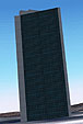
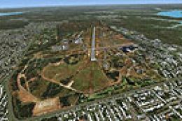
South African VFR navigation gains two standout landmarks with custom-modeled scenery for the Ergo Slimes Dam south of Benoni and the South African Reserve Bank tower in Pretoria, set on a crisp photoreal ground base. Built for FSX, it enhances low-level route planning and visual reference during local VFR flights.
This is the third release in a series of sceneries that cover the important VFR waypoints in South Africa. This package includes the Ergo Slimes dam south of Benoni and the South African Reserve Bank tower in Pretoria. This is freeware and made from custom designed objects and also has a photoreal base. By Philip Schall, PSDS.
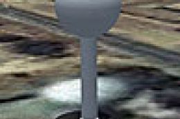
Screenshot of a South African scenery waypoint.
Free for all simmers · 3.95 MB · Scanned clean Aug 2026
Download speed: Free tier is capped at 0.5 Mbps (this file takes approximately 1 min at the cap). PRO members download at full line speed.
SimObjects\Airplanes\, Addon Scenery\, Effects\, or Gauges\.readme.txt or README file. It tells you exactly where files go, what dependencies are needed, and any quirks specific to this add-on.Use these coordinates to fly directly to this location once the mod is installed.
-25.74690000,28.18810000
Launch FSX or Prepar3D and use Flights → Load to open the downloaded .pln file. Your aircraft will be positioned at this location.
The archive savfrwaypoints3.zip has 18 files and directories contained within it.
This list displays the first 500 files in the package. If the package has more, you will need to download it to view them.
| Filename/Directory | File Date | File Size |
|---|---|---|
| SAVFRWaypoints3 | 01.20.13 | 0 B |
| Readme.txt | 01.20.13 | 852 B |
| SAVFRWaypoints3.jpg | 01.20.13 | 86.09 kB |
| scenery | 01.19.13 | 0 B |
| sawaypoints2.bgl | 01.19.13 | 991.00 kB |
| sawaypoints2_OBX.BGL | 01.19.13 | 220 B |
| voortrekkerphotobase.bgl | 01.19.13 | 3.26 MB |
| texture | 01.19.13 | 0 B |
| BuildingsHighRise0051_3_thumblarge.dds | 01.19.13 | 85.45 kB |
| Google_Earth_Snapshot1.dds | 01.19.13 | 341.45 kB |
| material_1.dds | 01.19.13 | 341.45 kB |
| material_2.dds | 01.19.13 | 170.78 kB |
| material_3.dds | 01.19.13 | 170.78 kB |
| material_4.dds | 01.19.13 | 2.79 kB |
| material_5.dds | 01.19.13 | 5.44 kB |
| _1.dds | 01.19.13 | 21.45 kB |
| flyawaysimulation.txt | 10.29.13 | 959 B |
| Go to Fly Away Simulation.url | 01.22.16 | 52 B |
Only PRO members can place votes.
More FSX & P3D add-ons hand-picked based on this download.
FSX Scenery
This is the second release in a series of sceneries that cover the important …
 FSX Scenery
Route Pack VI Waypoints. These are the waypoints for the infamous "Route Pack…
 FSX Scenery
South African Game Lodge Airstrips. Six real world airstrips re-created using…
 FSX Scenery
Scenery Greek Islands Vol. 2. This pack contains LGKR Kerkyra, LGKF Kefalloni…
 FSX Scenery
Ants Aussie Airports Vol. 4: Darwin International, Australia. Contains scener…
 FSX Scenery
North England Landmark Scenery Vol 1.a Geoff Smith To install If you have alr…
 FSX Scenery
Ants Aussie Airports Vol 9. Hamilton Is, QLD, Australia is a resort island in…
 FSX Scenery
Ants Aussie Airports Vol. 1: Snowy Mountains scenery, Australia. Contains sce…
Be the first to leave a comment on this download.
Be the first to share your thoughts on this download.