 FS2004 Utilities/Misc
Active Camera 2004
FS2004 Active Camera 2004 v2.1. This package includes both the install files,…
EasySatPix Europe streamlines preflight planning in FS2004 by pulling current satellite imagery, weather charts, analysis maps, precipitation and snow data, surface winds, icing, thunderstorms, turbulence, and upper-wind charts across Europe, Africa, and the Atlantic up to 53,000 feet. It sources updates from USAFE OWS for reliable situational awareness.
Free for all simmers · 39.43 KB · Scanned clean Jul 2026
Download speed: Free tier is capped at 0.5 Mbps. PRO members download at full line speed.
FS9\Aircraft\, FS9\Addon Scenery\, FS9\Gauges\, or FS9\Effects\.readme.txt or README file. It tells you exactly where files go, what dependencies are needed, and any quirks specific to this add-on.The archive easy_eur.zip has 3 files and directories contained within it.
This list displays the first 500 files in the package. If the package has more, you will need to download it to view them.
| Filename/Directory | File Date | File Size |
|---|---|---|
| EasySatPix.exe | 06.29.05 | 104.00 kB |
| flyawaysimulation.txt | 10.29.13 | 959 B |
| Go to Fly Away Simulation.url | 01.22.16 | 52 B |
Only PRO members can place votes.
More FS2004 add-ons hand-picked based on this download.
FS2004 Utilities/Misc
FS2004 Active Camera 2004 v2.1. This package includes both the install files,…
 FS2004 Utilities/Misc
All users of Massive Crash are urged to install this update. The files includ…
 FS2004 Utilities/Misc
FS2004 Better frame rates patch by Eddie Batista
 FS2004 Utilities/Misc
The Nasa Space Challenge is an extremly enjoyable experience for simulating N…
 FS2004 Utilities/Misc
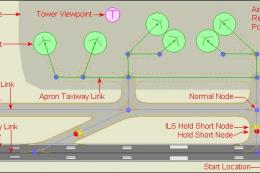
This is a CAD-style editor for FS2004 airports. Airports consist of visible s…
 FS2004 Utilities/Misc
Mouse-as-Yoke gauge for Microsoft Flight Simulator 2004. Great thing for flyi…
 FS2004 Utilities/Misc
Test your pilot skills shooting traps using top aircraft of today on the HMSN…
 FS2004 Utilities/Misc
Welcome to Real Environment Professional, an extensive environment upgrade pa…
Be the first to leave a comment on this download.
Be the first to share your thoughts on this download.