FSX Anacortes Airport Scenery
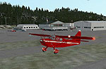
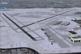
Anacortes Airport (74S) in Washington State gets a polished coastal makeover near the San Juan Islands, with reworked aprons, corrected roads, extra hangars and buildings, and carefully placed static aircraft, vehicles, light poles, and a flag for stronger atmosphere. Built for Microsoft Flight Simulator X and requires no external libraries.
 United States of America
 - File: anacort.zip
- Size:6.65 KB
- Scan:
Clean (28d)

- Access:Freeware
- Content:Everyone

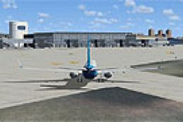
Discover a refined scenery package for Anacortes Airport (74S) in Washington State. Situated near the picturesque San Juan Islands, this airport provides an excellent coastal flying experience, and with these upgrades by Jim Cook, it becomes an even more appealing destination for short-hop flights in Microsoft Flight Simulator X. Improvements include updated aprons, adjusted road networks, additional hangar structures, static vehicle placements, and other subtle enhancements to capture the authentic feel of this regional airfield.
Ground Layout and Facility Enhancements
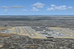
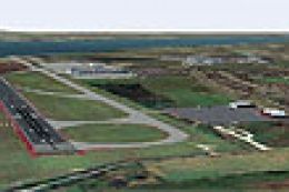
Anacortes Airport (located in Skagit County) features a modest layout that has been carefully optimized in this package. The author reconfigured default aprons to represent actual operational spaces more precisely. In addition, roadways have been reshaped to highlight airport boundaries and improve overall realism when taxiing or exploring ground routes in the simulator.
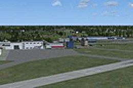
Expanded Hangars and Realistic Buildings
By analyzing official references (in brackets, refers to publicly available flight data) and satellite images, Jim Cook replaced generic building assets with more accurate hangar models and terminal structures. This well-researched substitution brings the environment closer to the real-life counterpart, ensuring the facilities align with real-world semantics. Additionally, unnecessary default objects were removed to maintain a cleaner aesthetic.
Visual Upgrades and Static Objects
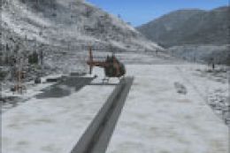
In order to immerse virtual pilots further, various static aircraft and vehicles have been thoughtfully placed around the tarmac and parking areas. The author incorporated custom light poles and a country flag, adding subtle touches that enhance the airport’s ambience. These details not only amplify the look and feel of the airfield but also provide extra visual cues during twilight or early morning operations.
Anacortes Airport Scenery.
Optional Complementary Add-Ons
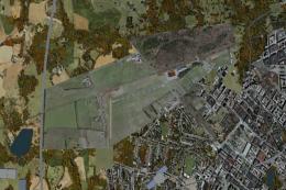
While this freeware scenery requires no external object libraries, the designer tested its compatibility with Ultimate Terrain and FSGenesis landclass products. These optional enhancements can further refine the surrounding Washington landscape, though they are not mandatory for enjoying the updated airport layout. The developer relied on AirNav resources and Google Earth for geographic accuracy and positional corrections.
Short Flight to Friday Harbor
A notable highlight in this region is the quick flight from Anacortes to Friday Harbor. This route over the Salish Sea showcases stunning island views, making the journey both relaxing and visually engaging. The newly refined airport area helps frame the departure experience and offers a welcoming runway for arrivals back into Anacortes.
Installation Process
- Extract the following files into your “Addon Scenery/Scenery” folder:
- 74S_AFX_JC.bgl
- 74S_JC.bgl
- Restart the simulator to load the changes.
These files were assembled using Flight 1’s AFX tool and Instant Scenery for advanced object placement, ensuring that all elements are properly integrated into the simulated environment.
Acknowledgments to the Creator
All enhancements described here were meticulously developed by Jim Cook. His commitment to crafting an authentic atmosphere reflects a deep understanding of local aviation features, ensuring that Anacortes Airport in Microsoft Flight Simulator X feels familiar to those who have visited the site in person. This freeware release aims to bring greater fidelity to every approach and departure from this scenic piece of the Pacific Northwest.

Finding the Scenery
- FSX/Prepar3D Coordinates:
-
48.49900000,-122.66200000
Use the downloaded flight plan file by launching FSX/P3D, selecting "Load Flight Plan" in the flight planner, and choosing the .pln file. Your aircraft will be positioned directly at the add-on’s location. - Decimal Degrees (DD):
-
Latitude: 48.499000°
Longitude: -122.662000° - Degrees, Minutes, Seconds (DMS):
-
Latitude: 48° 29' 56.400" N
Longitude: 122° 39' 43.200" W
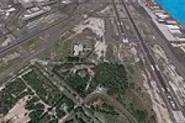
Map Location
The archive anacort.zip has 5 files and directories contained within it.
File Contents
This list displays the first 500 files in the package. If the package has more, you will need to download it to view them.
| Filename/Directory | File Date | File Size |
|---|---|---|
| 74S_JC.bgl | 11.29.08 | 4.26 kB |
| anacortes_read_me.txt | 11.29.08 | 892 B |
| 74S_AFX_JC.bgl | 11.29.08 | 7.19 kB |
| flyawaysimulation.txt | 10.29.13 | 959 B |
| Go to Fly Away Simulation.url | 01.22.16 | 52 B |
Installation Instructions
Most of the freeware add-on aircraft and scenery packages in our file library come with easy installation instructions which you can read above in the file description. For further installation help, please see our Flight School for our full range of tutorials or view the README file contained within the download. If in doubt, you may also ask a question or view existing answers in our dedicated Q&A forum.
0 comments
Leave a Response