FSX Vagar Faeroe Islands Scenery Update
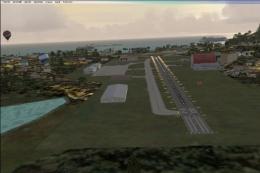
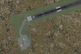
Vágar Airport (EKVG) in the Faroe Islands gets a sharper, more authentic layout with corrected terminal placement, added static detail, refined perimeter roads, and updated PAPI positioning. The runway is extended to 5,000 feet with distance boards and optional touchdown zone markings that require the FSX Runway Numbers And Markings library for full effect in Microsoft Flight Simulator X.
 Faroe Islands
 - File: vagar2fsx.zip
- Size:408.34 KB
- Scan:
Clean (9d)

- Access:Freeware
- Content:Everyone

This freeware scenery package refines the default representation of Vagar Airport (EKVG) in the Faroe Islands by adjusting building placement, extending the runway to 5000 feet, and adding accurate touchdown zone (TDZ) markings for those who wish to install an additional runway markings library. Created by John Ball, it offers numerous improvements to better reflect the real-world layout of Vagar, commonly referred to as Kirkenes airfield in some references, and provides a more engaging experience in Microsoft Flight Simulator X.
Enhanced Faroe Islands Environment
The Faroe Islands, located in the North Atlantic, are known for their rugged terrain, dramatic coastal cliffs, and swiftly changing weather. This update focuses on enhancing the primary airport, ensuring that virtual pilots can experience improved realism when navigating approaches and departures among these striking islands. Static objects, new buildings, and adjusted perimeter roads have been added to bring this location closer to its real-world counterpart.
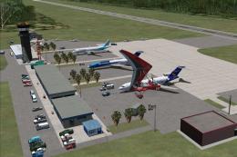
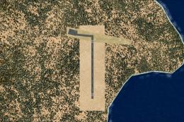
Overview of Vagar Faeroe Islands.
Key Adjustments and Additions
- Terminal Placement Rectification: Corrects the terminal building’s position for more accurate object placement around the main apron.
- Runway Expansion: Extends the landing strip to a total of 5000 feet, offering improved operational flexibility. Although the marked lengths between thresholds remain about 4000 feet, displaced thresholds are now accounted for.
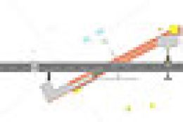
- TZD Markings: Integrates hand-placed touchdown zone details, including 500-foot bars, 1000-foot markings, and additional markers at 1500 feet. Full support for these elements requires the FSX Runway Numbers And Markings add-on by Lance Tucker, though the scenery remains functional without it.
- Navigational Aids: Includes repositioned PAPI lights at approximately 700 feet from each threshold, ensuring closer-to-real-world accuracy and corrected alignment for instrument approaches.
- Distance Boards: Introduces distance-to-go signage at intervals of 4000, 3000, 2000, and 1000 feet for enhanced situational awareness during takeoff and landing.
Compatibility and Basic Requirements
This scenery was developed with the standard MSFS X environment, so it has not been tested with other add-ons. It remains a fictionalized enhancement that respects the authentic layout as much as possible, and it refines the default airfield portrayal for a more immersive experience.
Optional Runway Markings Library
For those who desire full realism, the additional artwork found in the freeware FSX Runway Numbers And Markings library by Lance Tucker (filename: rwy_mark.zip) provides the custom touchdown zone paint that FSX normally omits on runways shorter than 6000 feet. Without these resources, you will still have complete scenery functionality, minus the detailed TDZ visuals on the surface.
Installation Procedure
- Open your main simulator directory, then locate Addon Scenery > Scenery.
- Place all EKVG_ADEX files (4 in total) into that folder.
- Optionally download and install the rwy_mark.zip package if you wish to take advantage of the advanced runway zones.
- Launch the simulator and navigate to airport code EKVG to view the updated scenery.
If the files overwrite an older version, that simply indicates a previous install of this mod. Once everything is in place, you should see the improvements around the apron, enhanced roads, and carefully placed markings. This version has been tested on author systems and is expected to function smoothly for most users. We trust you will find these changes helpful in exploring the stunning yet challenging approaches that the Faroe Islands have to offer.

Finding the Scenery
- FSX/Prepar3D Coordinates:
-
62.06370000,-7.27720000
Use the downloaded flight plan file by launching FSX/P3D, selecting "Load Flight Plan" in the flight planner, and choosing the .pln file. Your aircraft will be positioned directly at the add-on’s location. - Decimal Degrees (DD):
-
Latitude: 62.063700°
Longitude: -7.277200° - Degrees, Minutes, Seconds (DMS):
-
Latitude: 62° 03' 49.320" N
Longitude: 7° 16' 37.920" W
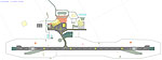
Map Location
The archive vagar2fsx.zip has 8 files and directories contained within it.
File Contents
This list displays the first 500 files in the package. If the package has more, you will need to download it to view them.
| Filename/Directory | File Date | File Size |
|---|---|---|
| Vagar.bmp | 01.29.11 | 6.37 MB |
| EKVG_ADEX_JB_CVX.bgl | 01.30.11 | 493 B |
| EKVG_ADEX_JB.ad2 | 01.30.11 | 300.29 kB |
| EKVG_ADEX_JB.BGL | 01.30.11 | 17.46 kB |
| EKVG_ADEX_JB.xml | 01.30.11 | 126.37 kB |
| Vagar2 Readme.txt | 01.30.11 | 2.66 kB |
| flyawaysimulation.txt | 10.29.13 | 959 B |
| Go to Fly Away Simulation.url | 01.22.16 | 52 B |
Installation Instructions
Most of the freeware add-on aircraft and scenery packages in our file library come with easy installation instructions which you can read above in the file description. For further installation help, please see our Flight School for our full range of tutorials or view the README file contained within the download. If in doubt, you may also ask a question or view existing answers in our dedicated Q&A forum.

0 comments
Leave a Response