 FSX Scenery
Small German Airfields
Small German Airfields EDAJ plus EDOT. AFCAD scenery for two smaler fields in…
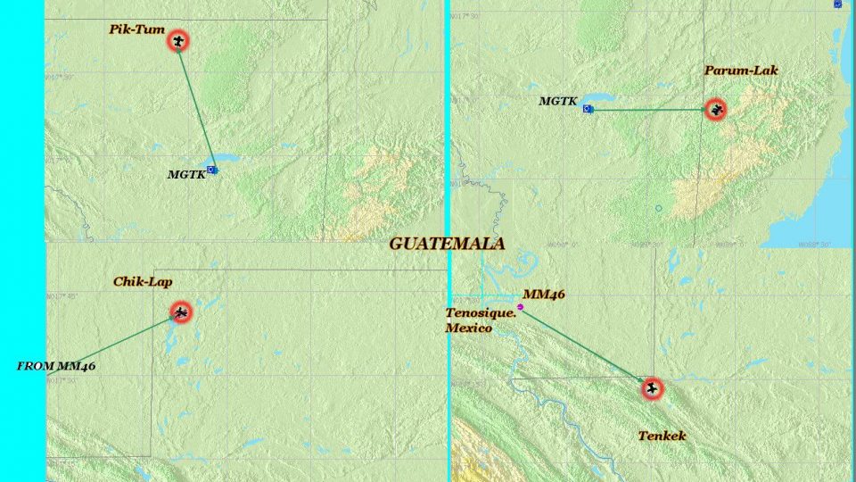
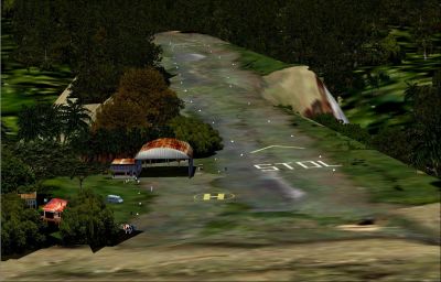
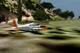
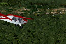
Small and Dangerous Airfields Scenery charts a fictional “Mayan Route” of four hidden, high-risk bush strips in Guatemala, built for short-field STOL flying and off-the-grid navigation using included references. Designed for FSX, it adds new BGL scenery and textures to turn Central America into a focused challenge playground.

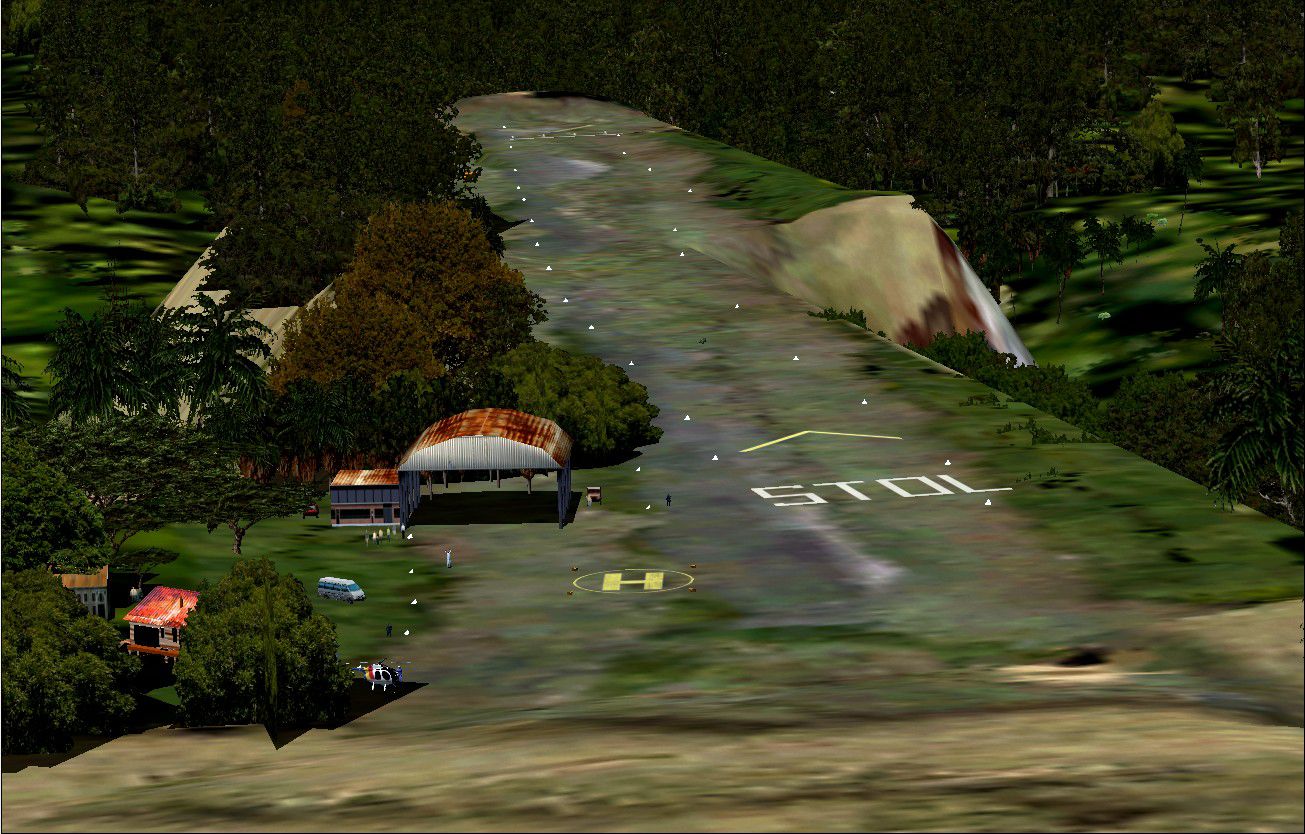
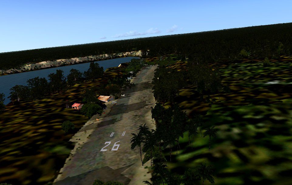
Small And Dangerous Airfields In Central America Part I (with a touch of salt). The OOWBP (Organization of Wreckless Bush Pilots) has put out a very confidential map of four very dangerous airfields in Guatemala, C.A. called the "Mayan Route" since they are located in an area where some few thousand of years ago the Mayas ruled. The government of this country has no comments on these since they are not shown in any of their aeronautical charts. The OOWBP has placed some reference on these charts which you can use as take off points in order to reach them easily. If you deside to take the "plunge" and fly to them make sure the aircraft you fly in is reliable and a very good STOL one... Have fun and let us know of your experience... The next episode is in Honduras, where by the way, the fifth president of OOWBP went missing six years ago... By Gera Godoy Canova.

Small And Dangerous Airfields Scenery.
"THE MAYAN ROUTE"
Episode I of the Series " Small and Dangerous Airfields of Central America" with salt.
The OOWBP (Organization of Wrekless Bush Pilots) has put out a very confidential map of four very dangerous airfields in Guatemala, C.A. called the "Mayan Route" since they are located in an area where some few thousand of years ago the Mayas ruled. The Government of this country has no comments on these since they are not shown in any of their aeronautical charts. The OOWBP has palced some reference on these charts which you can use as take off points in order to reach theM fearly easy. If you deside to take the "plunge" and fly to them make sure the aircraft you fly in is reliable and a very good STOL one......Have fun and let us know of your experience....
Must do:
1) Place the .BGL files in your FSX/Addon Scenery/Scenery directory
2) Plabe the .BMP files in your FSX/Addon Scenery/Textures directory
Activate the new files by going to your Menu and or simply close FSX and re-start it.
Have a nice flight.
Gera
Small And Dangerous Airfields Scenery.
Free for all simmers · 2.54 MB · Scanned clean
Download speed: Free tier is capped at 0.5 Mbps. PRO members download at full line speed.
FSX\Addon Scenery\ containing scenery and texture sub-folders.readme.txt or README file. It tells you exactly where files go, what dependencies are needed, and any quirks specific to this add-on.Use these coordinates to fly directly to this location once the mod is installed.
14.63490000,-90.50690000
Launch FSX or Prepar3D and use Flights → Load to open the downloaded .pln file. Your aircraft will be positioned at this location.
The archive danger01.zip has 24 files and directories contained within it.
This list displays the first 500 files in the package. If the package has more, you will need to download it to view them.
| Filename/Directory | File Date | File Size |
|---|---|---|
| AIRFIELDS LOCATION MAP.jpg | 10.15.09 | 481.51 kB |
| BALAK-TULUM.bgl | 10.15.09 | 18.09 kB |
| BALAK-TULUM2.bgl | 10.11.09 | 2.36 kB |
| CVX_GUATE-LAGO2.BGL | 10.11.09 | 590 B |
| CVX_PROJECT.BGL | 10.10.09 | 2.00 kB |
| CVX_TANTALANGUAT.BGL | 10.09.09 | 696 B |
| CVX_TARTKAN-4.BGL | 10.14.09 | 375 B |
| MGTK.BGL | 10.11.09 | 12.35 kB |
| BODEGA-CHINA.bgl | 08.29.09 | 9.34 kB |
| bodega-viej-1.bgl | 01.11.09 | 165.11 kB |
| BOD-MUE222.bgl | 09.09.09 | 4.26 MB |
| BOD-MUE01.bgl | 09.09.09 | 2.12 MB |
| HANGAROFFICE.bgl | 11.22.08 | 148.84 kB |
| CASACHINA.bgl | 04.18.09 | 4.52 kB |
| techo-viejo.bmp | 11.22.08 | 65.05 kB |
| techo-viejo-color2.bmp | 08.29.09 | 192.05 kB |
| casachina1.bmp | 03.21.09 | 33.05 kB |
| PIST-RUS.bmp | 02.27.09 | 257.05 kB |
| read me first.txt | 10.16.09 | 1.23 kB |
| FILE_ID.DIZ | 10.16.09 | 97 B |
| PACHUM-1.jpg | 10.09.09 | 324.96 kB |
| PATZUN-KILPU-3.jpg | 10.14.09 | 126.64 kB |
| flyawaysimulation.txt | 10.29.13 | 959 B |
| Go to Fly Away Simulation.url | 01.22.16 | 52 B |
More FSX & P3D add-ons hand-picked based on this download.
FSX Scenery
Small German Airfields EDAJ plus EDOT. AFCAD scenery for two smaler fields in…
 FSX Scenery
Christchurch Small Airfields. This adds NZWL, NZFF and updates NZRT which are…
 FSX Scenery
Costa Blanca Small Airfields; final release. These are updated files and incl…
 FSX Scenery
Dangerous Airfields Of The Andes Mountain. An FSX FSadventureSky Flight. Avia…
FSX Scenery
Set of 51 small airfields located from north to south of Portugal, the vast m…
 FSX Scenery
Western Kansas Airfields. Includes over 133 smaller Kansas (KS) airfields, ac…
 FSX Scenery
Scenery Amazonia Air II "Small Jungle Villages". The Peruvian Amazon is fille…
 FSX Scenery
Sardinia And Tuscan Airfields. This is a lot of 64 airfields covering the Ita…
Read what other simmers think, or add your own.
These strips look very nice but are nearly impossible to find. It would be great if you could make a saved flight or flight plan to them.