FSX Columbus/Bolton Field
Columbus–Bolton Field (KTZR) for Flight Simulator X refreshes the stock airport layout to match current charts and satellite references, with corrected taxiways, a dedicated transient ramp, updated terminal and tower placement, Capitol City Jet FBO, improved parking and hangar areas, and enhanced airfield lighting. Requires Jim Dhaenen’s scenery objects.

 United States of America
 - File: ktzr_columbus_bolton_field_oh.zip
- Size:9.27 MB
- Scan:
Clean (7d)

- Access:Freeware
- Content:Everyone

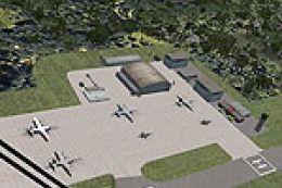
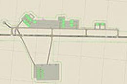
(KTZR), Columbus, Ohio (OH), USA. AFCAD for default/stock fsx airport only. Made with ADE 9X. Bolton Field serves as a GA reliever airport for Columbus, OH. This updates the airport according to the latest charts and Google satellite. Corrects the taxiways, adds the transient parking ramp, relocates new terminal with tower, adds the Capitol City Jet FBO, Jim Dhaenen's lights and T-hangars, parking lot and more. By Matthew Hollcraft.
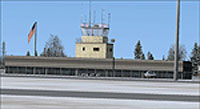
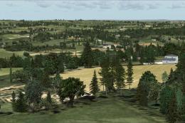
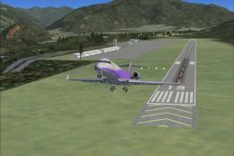
Screenshot of Columbus/Bolton Field.
Take the two BGL files (KTZR_ADEX_MH and KTZR_ADEX_MH_CVX) and place them in your Flight Simulator X/Addon Scenery/scenery folder. Copy and paste the Jim Dhaenens Scenery Objects folder as it is, into your Flight Simulator X/Addon Scenery/scenery folder. You will then have to activate it by opening FSX, going to settings>scenery library>add area, and choose the Jim Dhaenens scenery Objects folder. Restart FSX. If you already have Jim Daehens Lights or T-Hangers installed, delete the original files. If you have both already installed, this process is not necessary.

Finding the Scenery
- FSX/Prepar3D Coordinates:
-
39.90140000,-83.13680000
Use the downloaded flight plan file by launching FSX/P3D, selecting "Load Flight Plan" in the flight planner, and choosing the .pln file. Your aircraft will be positioned directly at the add-on’s location. - Decimal Degrees (DD):
-
Latitude: 39.901400°
Longitude: -83.136800° - Degrees, Minutes, Seconds (DMS):
-
Latitude: 39° 54' 05.040" N
Longitude: 83° 08' 12.480" W
Map Location
The archive ktzr_columbus_bolton_field_oh.zip has 22 files and directories contained within it.
File Contents
This list displays the first 500 files in the package. If the package has more, you will need to download it to view them.
| Filename/Directory | File Date | File Size |
|---|---|---|
| 1.BMP | 12.13.12 | 3.89 MB |
| 2.BMP | 12.13.12 | 3.89 MB |
| 3.BMP | 12.13.12 | 3.89 MB |
| 4.BMP | 12.13.12 | 3.89 MB |
| 5.BMP | 12.13.12 | 3.89 MB |
| Jim Dhaenens Scenery Objects | 12.13.12 | 0 B |
| Scenery | 12.13.12 | 0 B |
| lightobj.bgl | 11.29.12 | 643.63 kB |
| lightobj.txt | 11.29.12 | 547 B |
| Thangar.bgl | 11.30.12 | 1.10 MB |
| Thangar.txt | 11.30.12 | 200 B |
| Texture | 12.13.12 | 0 B |
| almwht.dds | 11.29.12 | 64.12 kB |
| lights1.dds | 11.29.12 | 32.12 kB |
| metal.dds | 11.30.12 | 128.12 kB |
| redprimr.dds | 11.30.12 | 32.12 kB |
| thgrwall.dds | 11.30.12 | 128.12 kB |
| KTZR_ADEX_CMH.BGL | 12.13.12 | 13.10 kB |
| KTZR_ADEX_CMH_CVX.bgl | 12.13.12 | 227 B |
| Readme.txt | 12.13.12 | 3.35 kB |
| flyawaysimulation.txt | 10.29.13 | 959 B |
| Go to Fly Away Simulation.url | 01.22.16 | 52 B |
Installation Instructions
Most of the freeware add-on aircraft and scenery packages in our file library come with easy installation instructions which you can read above in the file description. For further installation help, please see our Flight School for our full range of tutorials or view the README file contained within the download. If in doubt, you may also ask a question or view existing answers in our dedicated Q&A forum.


0 comments
Leave a Response