FSX openVFR Switzerland Terrain Scenery
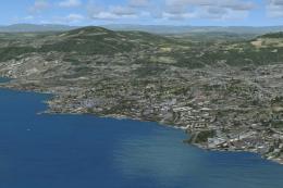
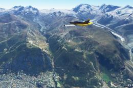
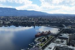
openVFR Switzerland Terrain Scenery sharpens VFR navigation with richer landclass, roads, railways, waterways, and improved points of interest sourced from curated OpenStreetMap data, bringing valleys, lakes, cities, and alpine terrain to life. Built for Microsoft Flight Simulator X, it layers cleanly over default terrain for a more faithful Swiss backdrop.
 Switzerland
 - File: openvfr_terrain_ch_20.zip
- Size:8.45 MB
- Scan:
Clean (25d)

- Access:Freeware
- Content:Everyone

This free add-on refines the Swiss environment within Microsoft Flight Simulator X by incorporating carefully curated elements from OpenStreetMap (OSM) [a user-driven cartographic resource]. Pilots looking to navigate visually will find this release particularly beneficial, as it integrates land classifications, roads, rail lines, waterways, and more. Developer openVFR, under the authorship of Markus Freyt, has ensured that the depiction of Switzerland’s diverse terrain becomes more immersive for virtual aviators.
Overview of the Scenery
The foundation of this scenery package lies in detailed geospatial information extracted primarily from OSM. By focusing on key categories, such as natural features (depicting vegetation and water bodies), leisure areas (covering sports facilities and recreational spaces), and landuse data (representing different surface utilization), it aims to fill gaps typically observed in default simulator terrain. Since the region showcases both mountainous expanses and lower-lying landscapes, precise topographical fidelity becomes critical for accurate visual flight.
Technical Insights
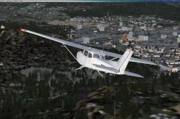
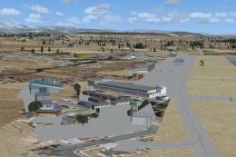
All extracted geographic data undergoes a transformation process, converting raw map information into valid scenery components that Flight Simulator X can render. This mechanism adds another layer of detail for each quadrant of Swiss territory and enriches the simulator’s base mesh. By processing structures like railways (tracks leading through valleys and over passes), roads (primary, secondary, and minor routes), and waterways (lakes and canals), the scenery attains new degrees of realism. Moreover, points of interest (POI) are enhanced to provide reference markers, improving situational awareness for VFR flyers.
Key Features
- High-resolution imagery derived from open-source mapping data for enhanced authenticity.
- Refined landscape classification, including farmland, forests, and urban zones, for accurate ground depiction.
- Diverse layers of data integration encompassing roads, rails, and water systems, yielded from OSM inputs.
- Enriched landmark coverage, offering recognizable reference points across the Swiss region.

openVFR Switzerland Terrain Scenery.
Performance Considerations
This package is structured to run smoothly on most hardware configurations that already manage default scenery without complications. However, incorporating additional terrain detail may demand slightly more GPU and CPU resources, especially in complex urban zones or during low-altitude maneuvers. Keeping simulator settings balanced aligns performance with visual enhancements.
Installation and Compatibility
The add-on installs alongside existing scenery layers; it does not overwrite default content. Users can activate or deactivate this modification in the simulator’s scenery library to evaluate the difference in terrain fidelity. Compatibility extends to various FSX configurations without the need for extra plugins, making it straightforward for any enthusiast seeking an all-encompassing Swiss VFR experience.
Created by openVFR and authored by Markus Freyt, this freeware release employs data-driven techniques to present Switzerland with increased precision. Visual flyers who value realistic cross-country navigation will appreciate this effort to capture the territory’s landscape in a more faithful manner.

Finding the Scenery
- FSX/Prepar3D Coordinates:
-
46.94790000,7.44460000
Use the downloaded flight plan file by launching FSX/P3D, selecting "Load Flight Plan" in the flight planner, and choosing the .pln file. Your aircraft will be positioned directly at the add-on’s location. - Decimal Degrees (DD):
-
Latitude: 46.947900°
Longitude: 7.444600° - Degrees, Minutes, Seconds (DMS):
-
Latitude: 46° 56' 52.440" N
Longitude: 7° 26' 40.560" E
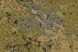
Map Location
The archive openvfr_terrain_ch_20.zip has 14 files and directories contained within it.
File Contents
This list displays the first 500 files in the package. If the package has more, you will need to download it to view them.
| Filename/Directory | File Date | File Size |
|---|---|---|
| openVFR_terrain_CH_2.0 | 01.21.10 | 0 B |
| openVFR_CH_2.0 | 01.20.10 | 0 B |
| Addon Scenery | 01.20.10 | 0 B |
| openVFR_Switzerland_Scenic | 01.14.10 | 0 B |
| Scenery | 01.18.10 | 0 B |
| CVX_switzerland.BGL | 01.15.10 | 13.56 MB |
| openVFR_Switzerland_Scenic_Exclude | 01.21.10 | 0 B |
| Scenery | 01.24.10 | 0 B |
| cvxEXCLUDE_CH.BGL | 01.24.10 | 31.34 kB |
| terrain.cfg | 11.04.06 | 159.02 kB |
| terrain_cfg_readme.htm | 11.05.06 | 11.88 kB |
| readme.pdf | 01.21.10 | 165.23 kB |
| flyawaysimulation.txt | 10.29.13 | 959 B |
| Go to Fly Away Simulation.url | 01.22.16 | 52 B |
Installation Instructions
Most of the freeware add-on aircraft and scenery packages in our file library come with easy installation instructions which you can read above in the file description. For further installation help, please see our Flight School for our full range of tutorials or view the README file contained within the download. If in doubt, you may also ask a question or view existing answers in our dedicated Q&A forum.


0 comments
Leave a Response