 FSX Scenery
openVFR Germany POI
This freeware scenery package transforms the German region within FSX by inco…
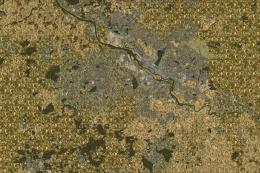
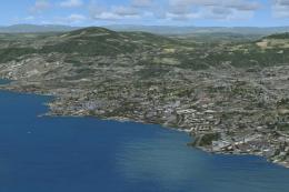
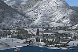
openVFR Switzerland POI scenery turns Switzerland into a richer VFR playground in Microsoft Flight Simulator X by drawing on OpenStreetMap data for landclass, waterways, rail lines, roads, leisure areas, and landmark points of interest. The result is clearer visual navigation and more believable urban and alpine landscapes for low-and-slow touring and cross-country routes.
This freeware package enriches Microsoft Flight Simulator X with an extensive collection of visual references throughout Switzerland, integrating data derived from OpenStreetMap sources. Designed to support VFR (Visual Flight Rules) flying, it leverages geospatial details such as land classification, leisure areas, waterways, rail lines, and numerous other points of interest. By incorporating these elements, the developers aim to provide a more immersive environment for virtual pilots who rely heavily on recognizable ground markers. However, it is worth noting that this scenery may put additional stress on system resources, so a robust PC is recommended.
Switzerland’s varied topology is captured by focusing on features ranging from landuse definitions (indicating specific land utilization patterns) to natural data (reflecting terrain forms, slopes, and vegetation zones). This attention to detail allows for more realistic flight planning, as each area now showcases unique characteristics that are relevant to both short hops and longer cross-country journeys.
The developers, led by Markus Freyt, incorporated a wide spectrum of dataset layers to enhance roads, train tracks, and canals in a manner that is consistent with real-world maps. These add crucial references that can help pilots maintain situational awareness. The accurate placement of highways, local road networks, and even minor rail connections further improves both low-level and high-altitude flight experiences.
Important urban layouts, including recreational areas and communal facilities, also receive thorough representations in this package. By integrating data tagged under leisure and amenity, the developers introduce more authentic depictions of parks, sports fields, and noteworthy gathering spots. These details prove especially valuable when flying slower aircraft and enjoying the scenery from a lower altitude.
Because this add-on is designed for visual navigation, it features a variety of POIs that match real-world landmarks, including popular tourist sites and culturally significant structures. These markers add layers of authenticity, making VFR flying throughout Switzerland more engaging and informative.
By incorporating these diverse datasets, the scenery can present a heavier load on your system than standard FSX scenery. Users with less capable hardware may observe lower frame rates, so optimizing display settings might be beneficial. The creators have marked this release as experimental, indicating potential updates or refinements may appear.

openVFR Switzerland POI Scenery.
Created by Markus Freyt. This freeware release continues to evolve, aiming to provide the FSX enthusiast community with a deeper sense of realism when flying across Switzerland’s diverse landscapes.
Free for all simmers · 48.03 KB · Scanned clean Jul 2026
Download speed: Free tier is capped at 0.5 Mbps. PRO members download at full line speed.
FSX\Addon Scenery\ containing scenery and texture sub-folders.readme.txt or README file. It tells you exactly where files go, what dependencies are needed, and any quirks specific to this add-on.Use these coordinates to fly directly to this location once the mod is installed.
46.94800000,7.44740000
Launch FSX or Prepar3D and use Flights → Load to open the downloaded .pln file. Your aircraft will be positioned at this location.
The archive openvfr_poi_ch_20.zip has 8 files and directories contained within it.
This list displays the first 500 files in the package. If the package has more, you will need to download it to view them.
| Filename/Directory | File Date | File Size |
|---|---|---|
| openVFR_poi_CH_2.0 | 01.22.10 | 0 B |
| openVFR_CH_2.0 | 01.20.10 | 0 B |
| Addon Scenery | 01.20.10 | 0 B |
| openVFR_Switzerland_Scenic | 01.14.10 | 0 B |
| Scenery | 01.18.10 | 0 B |
| switzerland-objects_OBX.BGL | 01.18.10 | 364.62 kB |
| flyawaysimulation.txt | 10.29.13 | 959 B |
| Go to Fly Away Simulation.url | 01.22.16 | 52 B |
Only PRO members can place votes.
More FSX & P3D add-ons hand-picked based on this download.
FSX Scenery
This freeware scenery package transforms the German region within FSX by inco…
 FSX Scenery
This freeware add-on enriches Microsoft Flight Simulator X with an elaborate …
 FSX Scenery
This free add-on refines the Swiss environment within Microsoft Flight Simula…
 FSX Scenery
This freeware scenery enhances the German landscape in FSX by incorporating d…
 FSX Scenery
This freeware release enriches the default environment in Flight Simulator by…
 FSX Scenery
This freeware scenery package augments default FSX terrain across The Netherl…
 FSX Scenery
FSX Landclass Scenery For Switzerland. Corrects and/or positions the cities a…
 FSX Scenery
Switzerland Alps Scenery. These files enhance some smaller airports for your …
Be the first to leave a comment on this download.
Be the first to share your thoughts on this download.