Guam 3M Terrain Mesh Scenery Updated by Emerald Scenery Design
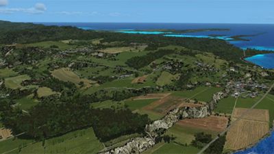
In this newly refined 3m terrain mesh by Emerald Scenery Design for FSX and P3D, every slope and contour across Guam is meticulously…
 Now available for FS2002 and FS2004 from Raimondo Taburet is 76.4 meter resolution SRTM mesh scenery of Europe. Areas available so far include Germany, France, Iberia and Italy. For more information, click on Read More.
Raimondo Taburet, owner and webmaster of FSfreeware.com and famous in the Flight Simulator world for his many terrain mesh products, has now started to release a new series of European terrain mesh for FS2002 and FS2004, based on the SRTM data from NIMA/NASA. The mesh is of a 76.4 meter resolution, which makes it a lot more detailed than the default mesh provided by Microsoft for this region.
The Shuttle Radar Topography Mission (SRTM) obtained elevation data on a near-global scale to generate the most complete high-resolution digital topographic database of Earth. SRTM consisted of a specially modified radar system that flew onboard the Space Shuttle Endeavour during an 11-day mission in February of 2000. SRTM is an international project spearheaded by the National Imagery and Mapping Agency (NIMA) and the National Aeronautics and Space Administration (NASA).
Raimondo's new series is called SRTM Terrain Environment (STE) and will include all of the European countries. It is a very priceworthy product, at Euros 8.99 per country, allowing most flightsimmers to obtain all of Europe for a reasonable price.
After Europe Raimondo will continue his series moving east, covering all of Eurasia by the time he is finished.
Upgrade Microsoft Flight Simulator, FSX, P3D & X-Plane in minutes with our curated file library packed with aircraft, scenery, liveries, and utilities.
Ready to upgrade your hangar?
Browse the free file library
Ian Stephens is a flight simulation industry expert with over 20 years of experience and also has a keen interest in aviation and technology. Ian spends a lot of his time experimenting with various simulator packages but has a love for Microsoft Flight Simulator X because of the huge selection of add-ons available. However, Ian also has copies of Prepar3D and X-Plane installed.
Ian has been writing for Fly Away Simulation for over 9 years. Should you wish, you can contact Ian via email at ian.stephens@flyawaysimulation.com.
In this newly refined 3m terrain mesh by Emerald Scenery Design for FSX and P3D, every slope and contour across Guam is meticulously…

Taburet’s new Night 3D British Isles update revolutionizes after-dark flights with vibrant 3D lighting that brings roads, coastlines, and…

This newly launched CRJ pack from Virtualcol brings genuine cockpit instrumentation, global airline repaints, and resource-friendly…

Immerse yourself in Carenado’s exquisite Cessna S550 Citation II HD Series for FSX/P3D, featuring intricately modeled flight decks,…
-400.jpg)
Take advantage of Warbirdsim’s limited-time deal on their iconic P-51D Mustang “Cadillac of the Skies Series,” meticulously tailored…

Abacus has introduced an all-new Mini Collection Series for FS2004 and FSX, bundling a diverse array of aircraft across multiple packages…
0 comments
Leave a Response