Page 66
Searches the whole library — filter by sim & category on the results page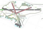
By John Ball, a complete remodelling of Aberdeen (EGPD) Airport uses ADE9x to rebuild the layout and adds four named EGPD files. The work preserves Scotland’s aviation context and marks a refined a…
 United Kingdom
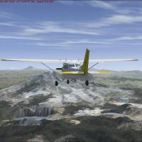
By Cesar Marinho, this equator region mesh correction adjusts the elevations of lakes surrounding Quito, Ecuador. It relies on the file Quito_Flatten.BGL and requires a compatible 2008-era mesh dat…
 Ecuador
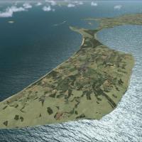
Version 1.0 presents a vector map covering all of Denmark, using AIS data from the National Environmental Research Institute and OpenStreetMap data under a Creative Commons license, adding custom p…
 Denmark
Johnson Creek, FAA ID 3U2, sits on a 40-acre tract in Valley County, Idaho, with a single grass runway 17/35 measuring 3,400 by 150 feet at 4,933 feet elevation. The rendition depicts volumetric gr…
 United States of America
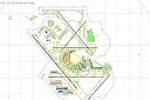
An update at O'Hare adds a 7500-foot runway 9L/27R and gates assigned to carriers, referenced by the file KORD_ADE_FS and replacing the stock layout. The arrangement splits operations into two inde…
United States of America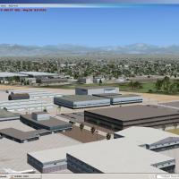
Scott Peterson designs a terminal area and cargo ramps for the KLGB site, aligning taxiways with airport diagrams and adding a UPS ramp. Two BGL files accompany the work, and Allegiant and Frontier…
United States of America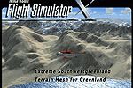
A terrain mesh for southwest Greenland covers latitudes 62 to 65 north, spans more than 60,000 square kilometers, and uses LOD11 elevation data with redesigned coastline and lakes. Three files name…
 Greenland
An arrangement centers on a CV-69 carrier with a Pensacola NAS setting for multiplayer, delivering a working meatball, ILS, GPS, and arrestor cables. Javier Fernandez updates add high-detail carrie…
United States of America
Volume 2 adds three UK airfields—EGTD Dunsfold, EGET Lerwick/Tingwall, and EGNF Netherthorpe—built from aerial views and using generic objects rather than dedicated assets, reflecting Alf Denham’s …
United Kingdom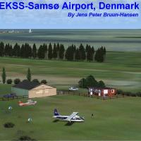
The EKSSX.ZIP archive includes two editions, EKSSX for Default and Ultimate Terrain Europa X and EKSS for the DAN-VFR Danish edition, centered on Samsoe’s area near Arhus, by Jens Peter Bruun-Hanse…
Denmark
Extends the Janet Terminal at KLAS with five gate and three ramp parking spots for Janet aircraft, where spots 110–114 suit 737-type Janet planes and 115–117 suit smaller Janet models. The arrangem…
United States of America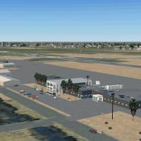
KBRO Brownsville/South Padre Island International Airport in Texas receives a modern terminal with interior access and a restored 1931 Pan Am building on the apron north of the current facility. It…
United States of America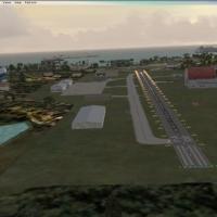
Eight islands compose this Virgin Islands default environment, offering an ILS approach for Princes Juliana runway 09 and related facilities while preserving stable frame rates. STARSEED PRODUCTION…
 Global (World)
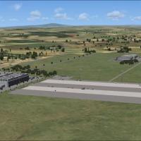
Located in Malawi, Africa, Lilongwe(FWKI) represents an international airport near Lake Malawi, made from default library objects, with the lake lying to the east. It features a working windsock an…
 Malawi
Yakima area enhancements cover KYKM and nearby locales such as the City of Yakima, Selah, Union Gap, Naches, and the Yakima Firing Center. By Gene Davis, it uses *.bgl files and requires Accelerati…
United States of America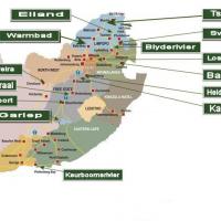
Overvaal Resorts spans locations across South Africa, including Keurboomsrivier at Plettenberg Bay, Bela-Bela with Eiland near Phalaborwa, and Rob Ferreira near Cristiana. It adheres to SP2 specifi…
 South Africa
LFSE airfield in Epinal-Dogneville, France, receives a complete landclass redesign of Epinal city, with a ground that shows seasonal and night variants. Animated windsock, static planes, cars, and …
 France
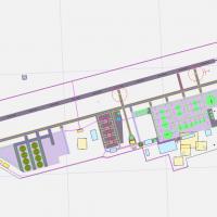
Aden in Yemen (OYAA) uses satellite imagery to guide a stock-airport-based upgrade, adjusting aprons and taxiways and adding parking spots plus vehicle paths. A single .bgl file, released into the …
 Yemen
Yemen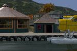
Whistler area adds a float-plane base named Whistler-Green Lake Water Aerodrome (CAE5) and two heliports, Whistler Health Care Centre Heliport CAW4 in town and Whistler Municipal Heliport CBE9 just…
 Canada
In the Western Cape, South Africa, Ysterplaat Airport (FAYP) carries version 1.00 with credits to Lourens Basson, Johan van Wyk, and Aeroworx. It features photo realistic ground surfaces with hanga…
South Africa