Page 61
Searches the whole library — filter by sim & category on the results page
Aeroworx presents enhanced South African sites around Theewaterskloof dam, Brandvlei dam, Krugersdrift dam, Kimberley Town, Big diamond holes, and Dealesville, using default and Gmax objects. Creat…
 South Africa
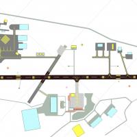
John Ball delivers improvements around Coventry’s EGBE airfield, adding custom buildings. The main runway 05/23 measures 6,600 feet with 600-foot and 700-foot displaced thresholds, while runway 17/…
 United Kingdom
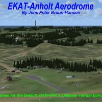
Two EKAT editions exist for Anholt Island: EKAT for Default & Ultimate Terrain Europa X, and EKAT for DAN-VFR Danish Photo coverage, in EKATX.ZIP, with Jens Peter Bruun-Hansen credited as the freew…
 Denmark
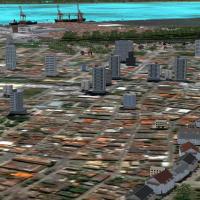
Gilson Cirino develops a landclass project that covers Paranaguá town, its port, Ilha do Mel, and rural areas along Paraná’s southern coast, with a file set including cvx_XXX.bgl, Ilhadomel.bgl, Pa…
 Brazil
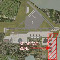
The KNIP facility in Florida enters a third rendition, adding two new hangars—one helicopter hangar on the seawall and one P-3 hangar by the VP-30 complex. The build relies on a mix of native libra…
 United States of America
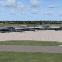
An add-on for KPNS in Florida lengthens runways, reshapes taxiways, and adds a localizer for runway 26 with nearby landclass updates. Art Poole authors the project, and it includes a library of new…
United States of America
At Florida's KTPA in the Tampa region, airline-specific gates map to real operator placements and cargo ramps reflect current logistics, by Rob Touchtone. Jetways are fully active and controllable …
United States of America
Nordholz v1 places the installation at Nordholz in Lower Saxony, home to Marinefliegergeschwader 3 Graf Zeppelin with IACO code ETMN. The archive ETMN_Nordholz-AB_V1.zip contains two bgl files and …
 Germany
By Kelan Reilly, Steamboat X Mega Pack v2 charts the Yampa Vally Regional Airport in Hayden, Colorado, and the surrounding Steamboat Springs area, including the KHDN terminal built from scratch. It…
United States of America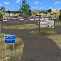
An add-on for Napier Airport in the Hawkes Bay region of New Zealand, this freeware project credits Godfrey Tier for custom buildings and a Godwit statue, with Lawrie Roache handling object placeme…
 New Zealand
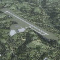
Branson Airport near Branson, Missouri (KBBG) opens in May 2009 as a privately developed commercial facility. It uses ICAO BBG and IATA BKG, bears Version 1.00 by Carlyle Sharpe, and relies on modi…
United States of America
CYFB Iqualuit presents an upgraded apron and parking area, capable of welcoming all aircraft types and up to the B737 series. A single .bgl file accompanies it, and airport information along with c…
 Canada
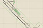
Jim Cook delivers a Davis-Monthan AFB upgrade in Tucson, Arizona, as a detailed reinterpretation that updates taxiway and apron geometry, adds designated military parking and helipads, and replaces…
United States of America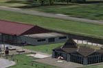
Located at Lunéville, France, LFQC presents photoreal ground with seasonal variants and a city-wide landclass redraw that highlights the castle and surrounding buildings. The work shows 47 custom m…
 France
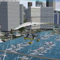
Orion Lyau presents a harbor enhancement for Honolulu, Hawaii, adding boats, docks, and birds to the area around the Yacht Club. The work centers on the file honolulu yatch harbor.bgl, credited to …
United States of America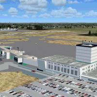
Jackson, Mississippi’s KJAN facility features a custom terminal and a dedicated C-17 hangar for the Mississippi ANG, plus air cargo areas and a central fuel-truck route. The installation relies on …
United States of America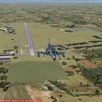
Located in southern Germany near Landsberg (ETSL), Lechfeld AB v1 anchors an active Luftwaffe base with a clear operational role. It houses Jagdbombergeschwader 32, which operates the Tornado ECR, …
Germany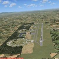
Located in southern Germany near Karlsruhe and Baden-Baden, the Baden-Sollingen AB site (EDSB) evolves from Cold War Canadian use to civilian Baden Airpark. The layout combines ADE X 1.50 and stock…
Germany
Kai P. Kamjunke, in collaboration with Alpha-India Group, develops Seychelles Landclass CVX, replacing the default landclass with dedicated BGLs and adding roads around Mahé and Praslin, plus objec…
 Seychelles
Raimondo Taburet creates a 19-meter mesh covering the Balearic archipelago, delivering considerably finer detail than SRTM data for flight simulation contexts. The work remains free to distribute a…
 Spain
Spain