 FS2002
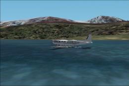
British Columbia Floatplane Pilot Flights package for FS2002
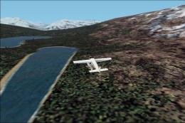
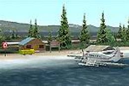
As a Cessna Caravan Amphibian pilot in British Columbia, fly tourists and res…
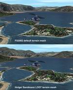
British Columbia and Southeast Alaska gain a 300 m (LOD7) terrain mesh for FS2002, built from 250 m source data without oversampling for smooth performance and modest storage use. Fourteen selectable tiles sharpen mountain profiles and reveal more convincing topography from Vancouver to Atlin, Juneau to Fort St. John, and Mount Robson to Clayoquot Sound.
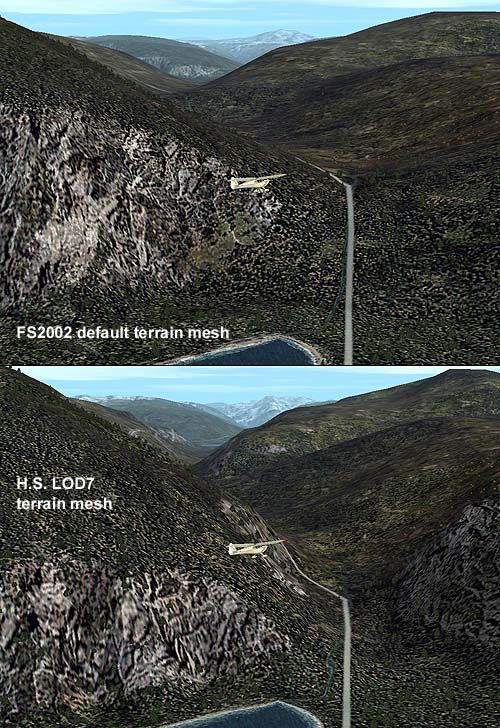
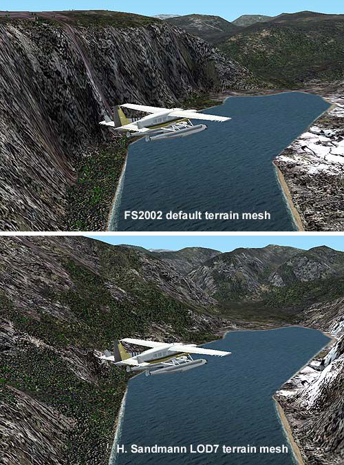
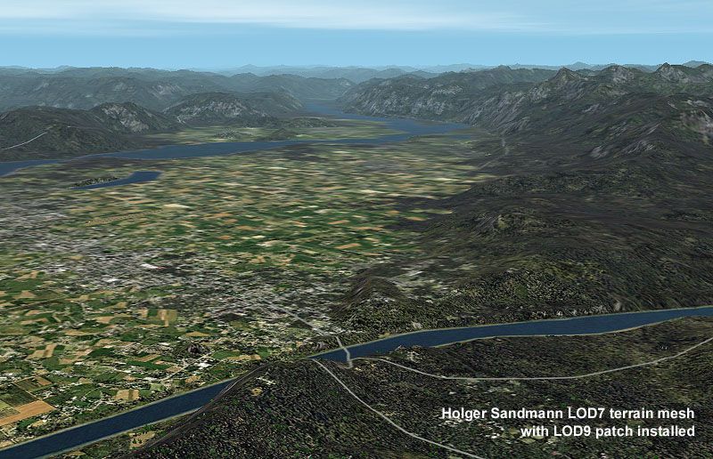
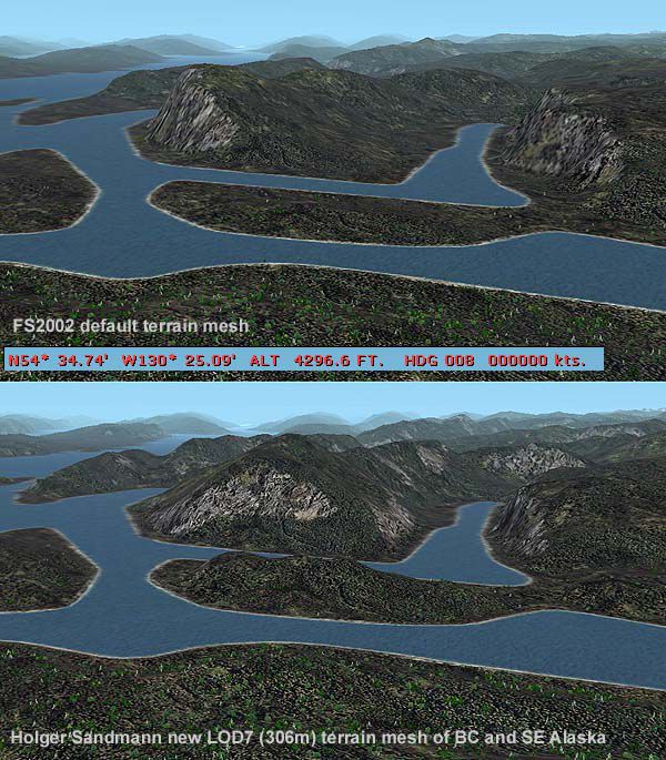
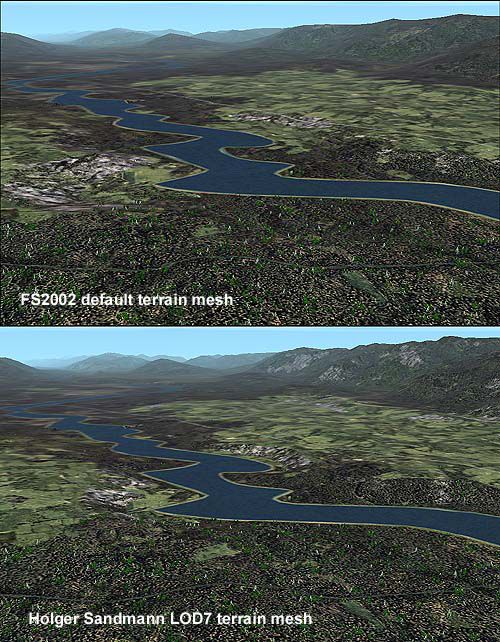
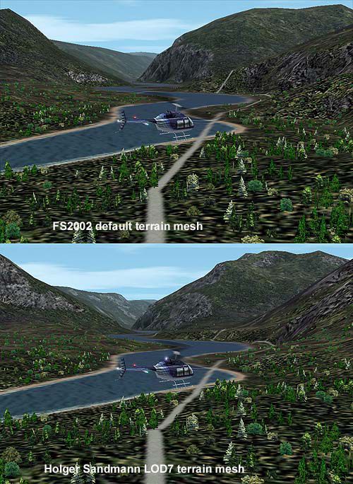
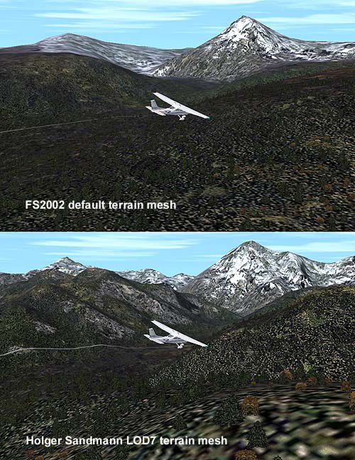
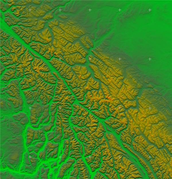
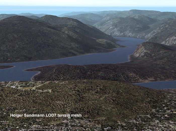
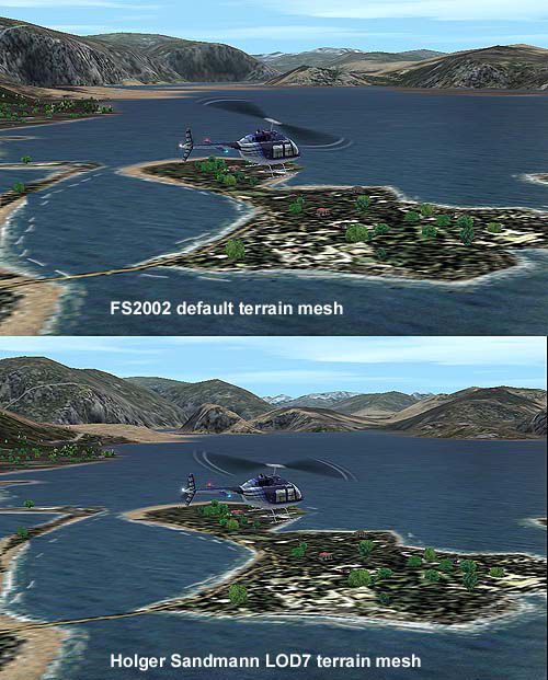
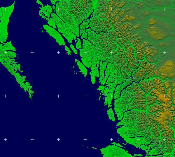
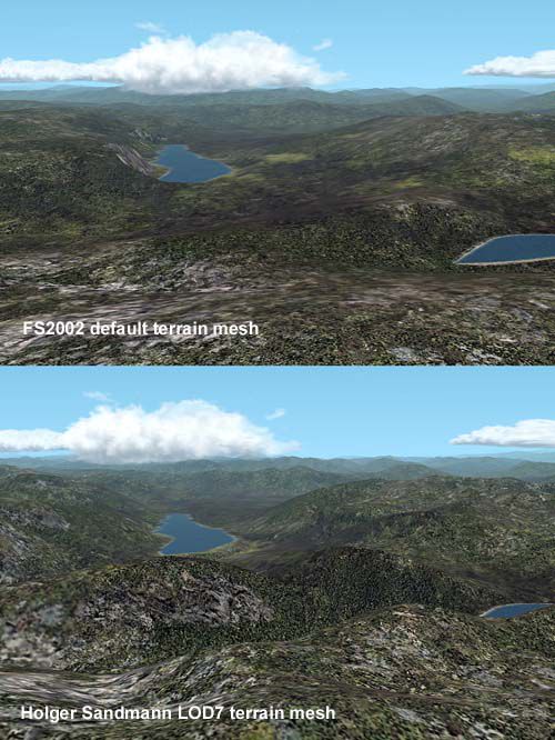
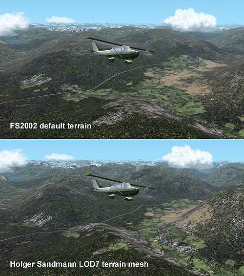
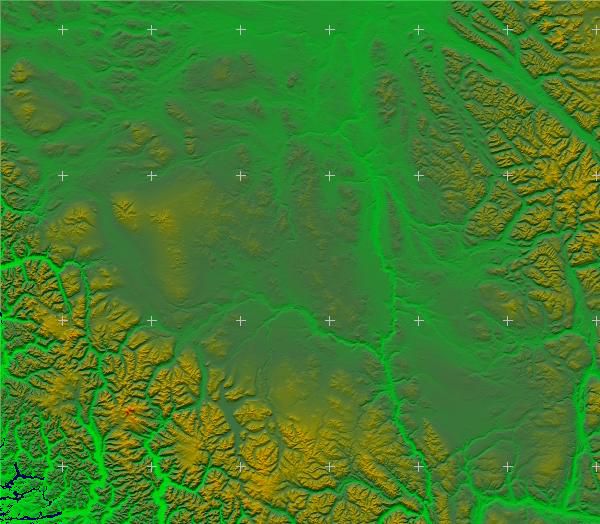

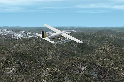
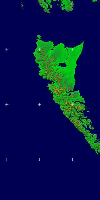
New 300-m (LOD7) Terrain Mesh of British Columbia and Southeast Alaska. Mid-resolution (300-m) terrain mesh for the entire province of British Columbia (950,000 square km) and the Alaska panhandle southeast of N60 W139. Made from 250m-resolution source data without oversampling. Easy on frame rates and hard drive space. It transforms the rounded mountains of the default terrain mesh into a much more realistic representation of the diverse topography of this beautiful corner of the world. Experience the spectacular scenery between Vancouver and Atlin, Juneau and Fort St. John, and Mount Robson to Clayoquot Sound. Fourteen independent mesh tiles allow you to select the region(s) you like best. Several high-resolution add-on meshes will be uploaded separately. By Holger Sandmann.
Free for all simmers · 6.84 MB · Scanned clean Aug 2026
Download speed: Free tier is capped at 0.5 Mbps (this file takes approximately 2 mins at the cap). PRO members download at full line speed.
readme.txt or README file. It tells you exactly where files go, what dependencies are needed, and any quirks specific to this add-on.The archive bcmesh7.zip has 141 files and directories contained within it.
This list displays the first 500 files in the package. If the package has more, you will need to download it to view them.
| Filename/Directory | File Date | File Size |
|---|---|---|
| bcmesh7 | 09.13.12 | 0 B |
| __MACOSX | 09.13.12 | 0 B |
| bcmesh7 | 09.13.12 | 0 B |
| BC LOD7 terrain mesh | 09.13.12 | 0 B |
| BC LOD7 terrain mesh | 09.13.12 | 0 B |
| above the Alaska Highway near Mile 422- default vs HS LOD7.jpg | 01.16.03 | 77.32 kB |
| above Weissner Creek Lake N58 W125 - default vs HS LOD7.jpg | 01.16.03 | 75.63 kB |
| B206 after takeoff from Sitka PASI airport - default vs HS LOD7.jpg | 01.16.03 | 78.07 kB |
| B206 at TO from Bella Coola CYBD - default vs HS LOD7.jpg | 01.16.03 | 106.21 kB |
| C208 above Kitlope Lake - default vs HS LOD7.jpg | 01.16.03 | 123.51 kB |
| C208 near Eddontenajon Lake south of Iskut - HS LOD7.jpg | 01.16.03 | 99.25 kB |
| Cessna near Mt. Robson - default vs HS LOD7.jpg | 01.16.03 | 104.46 kB |
| Chilliwack area from 10000ft with Russel Dirks landclass - HS LOD7 with LOD9 fix.jpg | 01.16.03 | 151.88 kB |
| File_id.diz | 01.16.03 | 892 B |
| Hwy1 Three Valley Gap in Canuck - deafult vs HS LOD7.jpg | 01.16.03 | 131.59 kB |
| Kootenay River valley north of Cranbrook CYXC - deafult vs HS LOD7.jpg | 01.16.03 | 116.68 kB |
| mesh tile relief maps | 01.14.03 | 0 B |
| L7_5154_115120_Valemount.jpg | 01.14.03 | 85.25 kB |
| mesh tile relief maps | 09.13.12 | 0 B |
| L7_5154_120126_Williams Lake.jpg | 01.14.03 | 63.34 kB |
| L7_5154_126132_Bella Bella.jpg | 01.14.03 | 72.29 kB |
| L7_5254_132134_Queen Charlotte.jpg | 01.14.03 | 19.25 kB |
| mesh tile relief maps - readme.txt | 01.16.03 | 1.34 kB |
| readme bcmesh7.pdf | 01.16.03 | 17.02 kB |
| readme bcmesh7.txt | 01.16.03 | 17.55 kB |
| scenery | 01.14.03 | 0 B |
| L7_5154_115120.bgl | 01.12.03 | 1.86 MB |
| scenery | 09.13.12 | 0 B |
| L7_5154_120126.bgl | 01.12.03 | 2.08 MB |
| L7_5154_126132.bgl | 01.12.03 | 1.27 MB |
| L7_5254_132134.bgl | 01.12.03 | 167.50 kB |
| texture | 01.14.03 | 0 B |
| Tofino and Clayoquot Sound in the early morning - HS LOD7.jpg | 01.16.03 | 67.55 kB |
| Vancouver Burnaby Mountain and Indian Arm - HS LOD7.jpg | 01.16.03 | 88.47 kB |
| Work Channel and Portland Inlet N of Prince Rupert - default vs HS LOD7.jpg | 01.15.03 | 116.54 kB |
| flights | 09.13.12 | 0 B |
| flights | 09.13.12 | 0 B |
| BC terrain mesh flights | 09.13.12 | 0 B |
| BC terrain mesh flights | 09.13.12 | 0 B |
| BC terrain mesh Bella Coola CYBD.FLT | 01.14.03 | 7.41 kB |
| BC terrain mesh Bella Coola CYBD.WX | 01.14.03 | 184 B |
| BC terrain mesh Chilko Lake lodge CAG3.FLT | 01.16.03 | 7.25 kB |
| BC terrain mesh Chilko Lake lodge CAG3.WX | 01.14.03 | 184 B |
| BC terrain mesh Chilliwack CYCW.FLT | 01.14.03 | 7.24 kB |
| BC terrain mesh Chilliwack CYCW.WX | 01.14.03 | 184 B |
| BC terrain mesh Cranbrook CYXC.FLT | 01.14.03 | 7.48 kB |
| BC terrain mesh Cranbrook CYXC.WX | 01.14.03 | 184 B |
| BC terrain mesh Eddontenajon Lake south of Iskut.FLT | 01.16.03 | 7.49 kB |
| BC terrain mesh Eddontenajon Lake south of Iskut.WX | 01.16.03 | 140 B |
| BC terrain mesh Kitchener Lake in Tatlatui Park.FLT | 01.16.03 | 7.55 kB |
| BC terrain mesh Kitchener Lake in Tatlatui Park.WX | 01.14.03 | 184 B |
| BC terrain mesh Kitlope Lake.FLT | 01.16.03 | 7.47 kB |
| BC terrain mesh Kitlope Lake.WX | 01.16.03 | 140 B |
| BC terrain mesh Mile 422 Alaska Hwy CBK7.FLT | 01.16.03 | 7.24 kB |
| BC terrain mesh Mile 422 Alaska Hwy CBK7.WX | 01.14.03 | 184 B |
| BC terrain mesh Sitka Alaska PASI.FLT | 01.14.03 | 7.41 kB |
| BC terrain mesh Sitka Alaska PASI.WX | 01.14.03 | 184 B |
| BC terrain mesh Smithers CYYD.FLT | 01.15.03 | 7.46 kB |
| BC terrain mesh Smithers CYYD.WX | 01.14.03 | 184 B |
| BC terrain mesh Tarr Inlet in Galcier NP.FLT | 01.16.03 | 7.48 kB |
| BC terrain mesh Tarr Inlet in Galcier NP.WX | 01.16.03 | 140 B |
| BC terrain mesh Tofino in Clayoquot Sound.FLT | 01.14.03 | 7.46 kB |
| BC terrain mesh Tofino in Clayoquot Sound.WX | 01.14.03 | 96 B |
| BC terrain mesh Tsusiat Lake SW Vancouver Island.FLT | 01.16.03 | 7.51 kB |
| BC terrain mesh Tsusiat Lake SW Vancouver Island.WX | 01.14.03 | 96 B |
| BC terrain mesh Valemount CAH4.FLT | 01.16.03 | 7.25 kB |
| BC terrain mesh Valemount CAH4.WX | 01.14.03 | 184 B |
| BC terrain mesh Weissner Creek lake.FLT | 01.16.03 | 7.54 kB |
| BC terrain mesh Weissner Creek lake.WX | 01.14.03 | 140 B |
| flyawaysimulation.txt | 10.29.13 | 959 B |
| Go to Fly Away Simulation.url | 01.22.16 | 52 B |
Only PRO members can place votes.
Hand-picked add-ons similar to this download.
FS2002
As a Cessna Caravan Amphibian pilot in British Columbia, fly tourists and res…
 FS2002
Reg ID: N867AS A Delta Connection operator in the ASA"Wavy Gravy" Livery New …
 FS2002
This is a complete re-make of the seaplane base at Homer, Alaska, for FS2002 …
 FS2002
of the new POSKY GMAX 747-400 (G-CIVS) in the Canadian World Scheme, 'Whale R…
 FS2002
Original is default Microsoft FS2002 737_400. Repainted by Mark L Green.
 FS2002
Reg ID: VP-FBL Patrol the mysterious Antarctic of FS2002 in this specially de…
 FS2002
will not work in prior MSFS versions!! A pair of classic Fleet Canuck 80, Can…
 FS2002
As a Cessna Caravan Amphibian pilot in Yukon, fly tourists and residents from…
Be the first to leave a comment on this download.
Be the first to share your thoughts on this download.