FSX Angel Falls Venezuela Scenery
Angel Falls scenery brings Venezuela’s Salto Ángel in Canaima National Park to life with a dramatic waterfall drop and custom effects near Canaima Airport (SVCN), inspired by the Auyán Tepui landmark. Built for Microsoft Flight Simulator X, it requires compatible regional terrain mesh for accurate placement and a convincing approach.

 Venezuela (Bolivarian Republic of)
 - File: angelfallsfsx.zip
- Size:31.06 KB
- Scan:
Clean (25d)

- Access:Freeware
- Content:Everyone

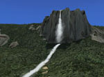
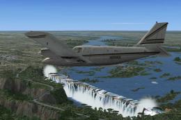
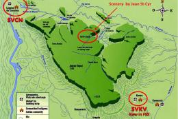
Scenery Angel Falls Venezuela. Angel Falls, Canaima National Park, Venezuela. Discovered in 1933 by an American pilot, Jimmie Angel, Angel Falls is located on Auyan Tepui near Canaima (SVCN). It's the world's highest waterfall with a height of 979 meters. By Jean St-Cyr.
Angel Falls Venezuela Scenery.
SCENERY CONTENT:
Salto Angel:
World's Highest Waterfall
* THERE'S NO MESH INCLUDED WITH THIS SCENERY. THE ONLY ONE USED IS TO MAKE.
* THE STEP WHERE THE FALL DROPS.
* THIS SCENERY WILL NOT WORK PROPERLY WITHOUT MESH INSTALLED FOR THE AREA. YOU CAN DOWNLOAD A FREEWARE VERSION OF THE SOUTH-AMERICAN MESH.
IMPORTANT NOTE:
This scenery was developped using the above mentionned freeware mesh.
Pilots using payware mesh may encounters problem with the scene.
The scene was succefully tested with the following payware mesh:
- FS Genesis
- FS Global X
INSTALLATION:
SCENERY -
Unzip and copy the files to the "Addon Scenery" folder of Microsoft Flight Simulator X (FSX).
EFFECTS -
In order to see the fall, you must copy the EFFECTS files into the "Effects" folder of FSX.
-
Add the scenery in your FSX Scenery Library.
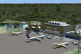
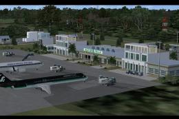
Start FSX at Canaima airport (SVCN) and enjoy flying toward the Angel Falls!

Finding the Scenery
- FSX/Prepar3D Coordinates:
-
5.96700000,-62.53500000
Use the downloaded flight plan file by launching FSX/P3D, selecting "Load Flight Plan" in the flight planner, and choosing the .pln file. Your aircraft will be positioned directly at the add-on’s location. - Decimal Degrees (DD):
-
Latitude: 5.967000°
Longitude: -62.535000° - Degrees, Minutes, Seconds (DMS):
-
Latitude: 5° 58' 01.200" N
Longitude: 62° 32' 06.000" W
Map Location
The archive angelfallsfsx.zip has 16 files and directories contained within it.
File Contents
This list displays the first 500 files in the package. If the package has more, you will need to download it to view them.
| Filename/Directory | File Date | File Size |
|---|---|---|
| AngelFalls | 02.16.10 | 0 B |
| Effects | 02.06.10 | 0 B |
| fx_JS_AngelFalls.fx | 02.06.10 | 8.49 kB |
| fx_JS_AngelFalls_Bottom.fx | 02.06.10 | 4.94 kB |
| fx_JS_AngelFalls_Bottom2.fx | 02.06.10 | 4.94 kB |
| fx_JS_AngelFalls_Bottom3.fx | 02.06.10 | 4.93 kB |
| fx_JS_AngelFalls_Bottom4.fx | 02.06.10 | 4.94 kB |
| Readme.txt | 02.12.10 | 3.77 kB |
| ReadmeFR.txt | 02.12.10 | 4.30 kB |
| Scenery | 02.06.10 | 0 B |
| AngelFalls.BGL | 02.07.10 | 8.90 kB |
| cvxANGELFALLS_BOTTOM_RIVER.BGL | 02.07.10 | 10.42 kB |
| cvxAUYANTEPUI.BGL | 02.05.10 | 273 B |
| thumbnail.jpg | 02.16.10 | 21.08 kB |
| flyawaysimulation.txt | 10.29.13 | 959 B |
| Go to Fly Away Simulation.url | 01.22.16 | 52 B |
Installation Instructions
Most of the freeware add-on aircraft and scenery packages in our file library come with easy installation instructions which you can read above in the file description. For further installation help, please see our Flight School for our full range of tutorials or view the README file contained within the download. If in doubt, you may also ask a question or view existing answers in our dedicated Q&A forum.

0 comments
Leave a Response