 FS2004 Scenery
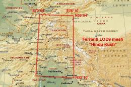
Himalayas LOD9 Base Mesh - Hindu Kush
This comprehensive terrain mesh package provides an enhanced representation o…
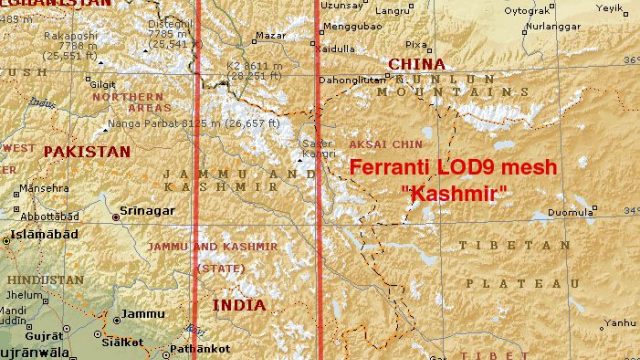
Himalayas LOD9 base mesh sharpens the Kashmir region with refined elevation data across N30°–39° and E76°–78°, filling SRTM voids for smoother ridgelines, valleys, and high-altitude contours. Built for Microsoft Flight Simulator 2004, it blends cleanly with LOD10 Himalayan Peaks coverage for more convincing mountain flying.


This freeware add-on provides an enhanced terrain mesh focused on coordinates N30°–39° and E76°–78°, incorporating refined data for the Himalayas near Kashmir. It was carefully compiled by Holger Sandmann, who leveraged input from Jonathan de Ferranti’s topographic map work to fill the gaps in the Shuttle Radar dataset. Designed primarily for Microsoft Flight Simulator 2004, it also remains compatible with FS2002 by retaining optimal resolution throughout the high-altitude zones.
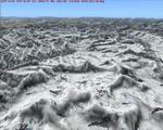
This mesh features LOD9 coverage (where LOD stands for Level of Detail), which supplies a crisp landform foundation across substantial parts of the Himalayan range. Because it covers rugged peaks and deep valleys, flight sim enthusiasts can navigate many challenging areas with an authentic representation of local geography. The dataset merges meticulously with the additional LOD10 Himalayan Peaks series, which further enhances specific highlands and mountainous ridges.
Because the raw Shuttle Radar Topography Mission (SRTM) readings sometimes contain data voids, Jonathan de Ferranti’s elevation models bridge the missing spots. This approach ensures a more complete landscape that aligns closely with real-world contours, minimizing abrupt flat sections or inaccuracies often encountered in default scenery.
The coverage region is centered near Kashmir and encompasses the adjacent mountainous terrain, including deep river valleys and extensive slopes. Aviators who plan virtual flights in this historically significant area will notice improved visual transitions between elevated ridgelines and plateaus, making approaches and takeoffs feel more engaging.
Installation is straightforward, ensuring easy adoption into Microsoft Flight Simulator 2004. The result is a more immersive environment, especially for bush flying aficionados or those who frequently operate near remote Himalayan airfields. This upgrade substantially refines the default mesh accuracy and elevates the entire region’s appearance.
Free for all simmers · 29.24 MB · Scanned clean
Download speed: Free tier is capped at 0.5 Mbps (this file takes approximately 8 mins at the cap). PRO members download at full line speed.
FS9\Aircraft\, FS9\Addon Scenery\, FS9\Gauges\, or FS9\Effects\.readme.txt or README file. It tells you exactly where files go, what dependencies are needed, and any quirks specific to this add-on.The archive fs_him_b4.zip has 14 files and directories contained within it.
This list displays the first 500 files in the package. If the package has more, you will need to download it to view them.
| Filename/Directory | File Date | File Size |
|---|---|---|
| fs_him_b4 | 02.21.06 | 0 B |
| File_id.diz | 02.21.06 | 453 B |
| fs_him_b4.gif | 02.11.06 | 14.16 kB |
| Himalayan Base Mesh 4 - Kashmir | 02.21.06 | 0 B |
| Himalayas - Kashmir - Zaskar.jpg | 01.29.06 | 111.40 kB |
| map Himalayas base mesh - Kashmir.jpg | 02.06.06 | 302.99 kB |
| mesh Himalayas by Ferranti & Sandmann | 02.07.06 | 0 B |
| scenery | 02.21.06 | 0 B |
| mesh_Himalayas_base_Kashmir_LOD7.bgl | 02.21.06 | 1.80 MB |
| mesh_Himalayas_base_Kashmir_LOD8.bgl | 02.21.06 | 5.97 MB |
| mesh_Himalayas_base_Kashmir_LOD9.bgl | 02.21.06 | 22.64 MB |
| readme fs_him_b4.txt | 02.21.06 | 8.92 kB |
| flyawaysimulation.txt | 10.29.13 | 959 B |
| Go to Fly Away Simulation.url | 01.22.16 | 52 B |
More FS2004 add-ons hand-picked based on this download.
FS2004 Scenery
This comprehensive terrain mesh package provides an enhanced representation o…
 FS2004 Scenery
Island of Tahiti, French Polynesia...FAAA, I.D. NTAA By: Bill Melichar This i…
 FS2004 Scenery
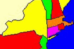
New York and New England 1-Arc Second LOD 10 Terrain Mesh Created from U.S. G…
 FS2004 Scenery
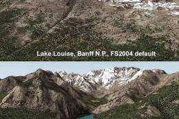
(N49-53, W112-116). All lake elevations are adjusted for best fit with the me…
 FS2004 Scenery
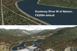
(N49-53, W116-120). All lake elevations are adjusted for best fit with the me…
 FS2004 Scenery
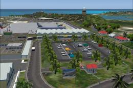
Princess Juliana is the scenery of the International Airport of St-Maarten in…
 FS2004 Scenery
Airport Environment Upgrade 7.0 (AEU7) will greatly enhance the Microsoft® Fl…
 FS2004 Scenery
This is my first complete new scenery for FS2004, and it enhances the entry a…
Be the first to leave a comment on this download.
Be the first to share your thoughts on this download.