FSX Horton Tower Scenery
Horton Tower in Dorset brings a distinctive seven-storey landmark to Southern England flying, offering a clear visual waypoint between Bournemouth (EGHH) and Compton Abbas (EGHA) with accurate placement and terrain-friendly ground alignment. Built for FSX, it also supports FS2004, and requires no special mesh to sit correctly.
Images & Screenshots
1 total
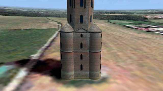
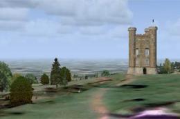
Horton Tower, UK. This seven storey tower is situated on high ground near the village of Horton in Dorset, England, and has been restored by a mobile phone company who use the upper story to discreetly mount several of their antenna. It is approximately 12 km northwest of Bournemouth International Airport and 18 km south east of Compton Abbas airfield and forms a useful waypoint between the two. Created by Andrew Ford.
Horton Tower Scenery.
NOTE: If possible please refer to the enclosed README.pdf
Location:
50:51:36.424N 1:57:29.538W
Ordnance Survey (OS) grid reference: SU 03038 06735
Installation:
Simply copy the unzipped "Horton Tower" folder (and its Scenery and Texture sub-folders) into the Addon Scenery sub-folder of Flight Sim. Then inside Flight Sim (FSX) select Settings > Scenery Library > Add Area... and navigate to and select the "Horton Tower" folder you just unzipped.
The Tower:
Horton Tower (aka Sturt’s Folly or Horton Observatory) is situated on an area of high ground near the village of Horton in Dorset, England. It is approximately 12km North West of Bournemouth International Airport (EGHH) and approximately 18km South East of Compton Abbas airfield (EGHA). As such it forms a useful waypoint between the two.
This seven storey tower is said to be approximately 47m high, but my measurements make it closer to 29m. I believe the discrepancy may be due to the loss of the tall dome which illustrations show used to form the roof of the tower. This could easily have added an extra third to the tower’s height. It is said to have been build by Thomas Sturt the Elder in 1726, either as an astronomical observatory or so he could follow the progress of the local hunt. Having fallen into disrepair it has been restored by a mobile phone company who use the upper story to discreetly mount several of their antenna.
The Scenery:
This FSDS v3 scenery was designed for and tested with FSX and Horizon Simulation’s VFR Generation X Volume 1 “Southern England & South Wales”.
However, it was created using MakeMDL and BGLcomp from the FS2004 SDK and therefore should also be compatible with FS2004 and Horizon Simulation’s VFR Terrain and VFR Photographic Scenery, England & Wales: Part 2 (also published by Just Flight as VFR Photographic Scenery Volume 2, Central & Southern England).
Crucially, the altitude above ground level (AGL) was set to zero in the XML file, so it’ll sit atop any terrain model (mesh) you might be using (inc. the default in Flight Sim mesh).
References:
Holt, J., 2000, Discover Dorset: Follies, The Dovecote Press
This scenery is released as Freeware.
Ready to download Horton Tower Scenery?
Free for all simmers · 466.55 KB · Scanned clean
File information
Download speed: Free tier is capped at 0.5 Mbps. PRO members download at full line speed.
How to install this mod
FSX / P3D
scenery
How to install this mod
-
Extract the downloaded archive
Use 7-Zip (free) or WinRAR to extract the ZIP to a temporary folder. Don't install while still zipped — the simulator can't read inside ZIP files. -
Place scenery in Addon Scenery
Create a folder underFSX\Addon Scenery\containingsceneryandtexturesub-folders. -
Activate in Scenery Library
In FSX, go to Settings → Scenery Library → Add Area. Higher priority means it overrides lower entries for the same location. -
Always read the included readme
Every mod ships with areadme.txtorREADMEfile. It tells you exactly where files go, what dependencies are needed, and any quirks specific to this add-on.
Finding the scenery
Use these coordinates to fly directly to this location once the mod is installed.
50.86011800,-1.95820400
Launch FSX or Prepar3D and use Flights → Load to open the downloaded .pln file. Your aircraft will be positioned at this location.
What’s inside this archive
The archive hortontw.zip has 13 files and directories contained within it.
File Contents
This list displays the first 500 files in the package. If the package has more, you will need to download it to view them.
| Filename/Directory | File Date | File Size |
|---|---|---|
| Horton Tower | 05.25.07 | 0 B |
| Horton Tower description for web.txt | 05.25.07 | 419 B |
| Horton Tower FSX & VFR GenX.jpg | 05.25.07 | 71.14 kB |
| Horton Tower.gif | 05.25.07 | 12.10 kB |
| READ ME.pdf | 05.25.07 | 83.94 kB |
| README.txt | 05.25.07 | 3.27 kB |
| scenery | 05.25.07 | 0 B |
| hortontower.bgl | 05.25.07 | 26.00 kB |
| texture | 05.25.07 | 0 B |
| hortontower.bmp | 05.25.07 | 682.74 kB |
| Thumbs.db | 05.25.07 | 8.50 kB |
| flyawaysimulation.txt | 10.29.13 | 959 B |
| Go to Fly Away Simulation.url | 01.22.16 | 52 B |


0 comments
Leave a Response