FSX openVFR The Netherlands POI Scenery
openVFR The Netherlands POI Scenery brings the Dutch landscape to life in Microsoft Flight Simulator X with dense, VFR-friendly points of interest built from OpenStreetMap data. Expect richer landuse, roads, railways, waterways, and recognizable features that improve low-level navigation and situational awareness while keeping the country’s real-world layout firmly in view.
- File: openvfr_poi_nl_20.zip
- Size:166.78 KB
- Scan:
Clean (25d)
- Access:Freeware
- Content:Everyone
This freeware add-on enriches Microsoft Flight Simulator X with an elaborate set of points of interest throughout the Netherlands, presenting a more engaging environment for those who prefer visual navigation. The scenery, developed by Markus Freyt, delivers advanced realism by drawing on extensive data from OpenStreetMap sources. Although this package provides a new dimension of geographical detail, it operates in an experimental phase and demands a high-performance system for smooth operation.
Enhancing the Dutch Landscape with Immersive Landmarks
When flying over the Netherlands, many pilots desire recognizable landmarks and detailed scenery to aid with extensive VFR exploration. In response, this mod populates the virtual terrain with numerous points of interest (often abbreviated as POI), offering a comprehensive depiction of the country’s layout. By including actual structures, roads, and other prominent features, virtual aviators can closely follow real-world paths, enhancing both immersion and orientation.
Integration of OpenStreetMap Data
The backbone of this scenery stems from the OpenStreetMap (OSM) project, which collects and curates cartographic information provided by contributors worldwide. This mod leverages critical OSM elements like landuse classification, leisure areas, natural landscapes, rail connections, roads, waterways, and additional points of interest. These elements blend seamlessly into the FSX environment, strengthening the correlation between what’s viewed in the simulator and actual on-site references.
Performance Requirements and Considerations
Because this package introduces numerous new objects and intricate details, it needs a robust computer setup to preserve fluid frame rates. Steady performance can be achieved by adjusting FSX’s graphics settings or selectively toggling certain scenery layers. Take a careful approach when balancing graphical fidelity and optimal performance, particularly if running multiple add-ons or high-resolution textures.
Unique Aspects of This Experimental Release
This rendition is currently classified as experimental. Users may notice subtle imperfections or extraordinary placement of certain elements, reflecting the ongoing nature of OSM contributions and scenery refinement. Despite these growing pains, the design intent remains focused on delivering extensive realism and interactive landmarks that accurately portray Dutch topography for those flying low and slow or crossing cross-country routes.

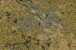
openVFR The Netherlands POI Scenery.
Credit to the Creator
By Markus Freyt, this freeware mod transforms the Dutch environment within FSX to align more closely with real-world topography. Many flight sim enthusiasts appreciate the meticulous planning involved in integrating propriety data with public geographic resources, ensuring the extended realism doesn’t compromise flight simulator integrity.
- Data Origins: OpenStreetMap-based
- Scope: Points of interest, roads, railways, waterways, landuse, and natural elements
- Usage: Designed for VFR pilots seeking higher accuracy
- Compatibility: Primarily for Microsoft Flight Simulator X
- Availability: Experimental freeware
Overall, users can anticipate a more vibrant and visually consistent Dutch VFR experience, perfect for casual flyers and dedicated hobbyists who crave realistic navigation. Despite its early stage, this project signals a dedicated move toward greater realism in FSX, representing an invaluable tool for those exploring the detailed geography of the Netherlands from the cockpit view.

Finding the Scenery
- FSX/Prepar3D Coordinates:
-
52.37021600,4.89516800
Use the downloaded flight plan file by launching FSX/P3D, selecting "Load Flight Plan" in the flight planner, and choosing the .pln file. Your aircraft will be positioned directly at the add-on’s location. - Decimal Degrees (DD):
-
Latitude: 52.370216°
Longitude: 4.895168° - Degrees, Minutes, Seconds (DMS):
-
Latitude: 52° 22' 12.778" N
Longitude: 4° 53' 42.605" E
Map Location
The archive openvfr_poi_nl_20.zip has 8 files and directories contained within it.
File Contents
This list displays the first 500 files in the package. If the package has more, you will need to download it to view them.
| Filename/Directory | File Date | File Size |
|---|---|---|
| openVFR_poi_NL_2.0 | 01.22.10 | 0 B |
| openVFR_NL_2.0 | 01.20.10 | 0 B |
| Addon Scenery | 01.20.10 | 0 B |
| openVFR_Netherlands_Scenic | 01.01.10 | 0 B |
| Scenery | 01.18.10 | 0 B |
| netherlands-objects_OBX.BGL | 01.18.10 | 1.73 MB |
| flyawaysimulation.txt | 10.29.13 | 959 B |
| Go to Fly Away Simulation.url | 01.22.16 | 52 B |
Installation Instructions
Most of the freeware add-on aircraft and scenery packages in our file library come with easy installation instructions which you can read above in the file description. For further installation help, please see our Flight School for our full range of tutorials or view the README file contained within the download. If in doubt, you may also ask a question or view existing answers in our dedicated Q&A forum.

 Netherlands






0 comments
Leave a Response