 FSX Scenery
Qamdo Bamda Airport (ZUBD)
Fly from the world's highest airport, taking off from the longest public runw…
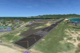
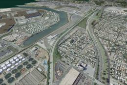
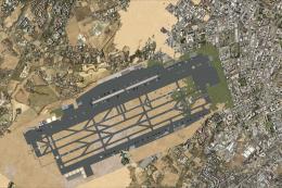
Qamdo Bangda Airport (ZUBD) scenery brings Tibet’s extreme-altitude gateway to life in FSX, capturing the 14,219-foot field elevation, 18,045-foot runway 14/32, and key airport buildings for realistic high-density-altitude operations. Includes ILS guidance for runway 14 plus reference maps to support accurate approaches and ground layout.
Scenery Qamdo Bangda Airport (ZUBD), Tibet, the highest airport in the world at 14,219 feet. By Anwar Gonzalez.
Qamdo Bangda Airport (IATA: BPX, ICAO: ZUBD) (pinyin: Changdu Bangdá Jicháng), located in Bangda, Qamdo, Tibet, is the highest airport in the world, at an elevation of 4,334 metres (14,219 ft). Runway 14/32 is the longest publicly used runway in the world, at 5,500 m (18,045 ft) (or 3.42 miles). The low air density at this altitude makes a higher takeoff and landing true airspeed necessary, and therefore a longer runway. The airport is 2.5 hours by mountain road from the county seat of Chamdu/Changdu/Qamdo. The long commute is the result of no flat land closer to the city being available to construct an airport. Visitors are warned before landing to move slowly on leaving the plane and that they may feel light headed or dizzy because of the thin air. However, Bangda will surrender its title of being the highest airport in the world. China is planning to build one at Nagqu at an elevation of 4,436 metres (14,500 ft). The construction is planned to start in 2011 and take three years to complete.
Elevation AMSL: 14,219 ft / 4,334 m
Coordinates: N30°33'13" E097°06'31"
Direction: 14/32
Length: 5,500 m/18,045 ft
Surface: Asphalt
INSTALLATION:
Please copy the fileS to the folder FSX Addon Scenery (subfolder Scenary). This file is the airpor with the ILS for runway 14 and airport buildings. It is done using google map. Included are two maps. Feel free to add anything you want.
Thank you for using this file.
THIS IS A FREEWARE FOR FSX
Anwar Gonzalez
Free for all simmers · 34.38 KB · Scanned clean Aug 2026
Download speed: Free tier is capped at 0.5 Mbps. PRO members download at full line speed.
FSX\Addon Scenery\ containing scenery and texture sub-folders.readme.txt or README file. It tells you exactly where files go, what dependencies are needed, and any quirks specific to this add-on.Use these coordinates to fly directly to this location once the mod is installed.
30.55360000,97.10860000
Launch FSX or Prepar3D and use Flights → Load to open the downloaded .pln file. Your aircraft will be positioned at this location.
The archive zubd.zip has 5 files and directories contained within it.
This list displays the first 500 files in the package. If the package has more, you will need to download it to view them.
| Filename/Directory | File Date | File Size |
|---|---|---|
| AFX_ZUBD.bgl | 07.02.10 | 30.98 kB |
| Please Read First.txt | 07.02.10 | 1.50 kB |
| ZUBD_ADEX_AG.BGL | 07.01.10 | 28.30 kB |
| flyawaysimulation.txt | 10.29.13 | 959 B |
| Go to Fly Away Simulation.url | 01.22.16 | 52 B |
Only PRO members can place votes.
More FSX & P3D add-ons hand-picked based on this download.
FSX Scenery
Fly from the world's highest airport, taking off from the longest public runw…
FSX Scenery
Scenery Bangda Tibet. Adds whole new airport with terminal and realistic alti…
 FSX Scenery
Princess Juliana International Airport (TNCM) in Saint Marteen, Netherlands A…
 FSX Scenery
Los Angeles Airport Scenery v3, California (CA). This photoreal scenery is a …
 FSX Scenery
Barbados International Airport (TBPB). Grantley Adams International Airport f…
 FSX Scenery
Paris Charles de Gaulle Airport (CDG, LFPG), France. The entire airport has b…
 FSX Scenery
John F. Kennedy Airport (KJFK), New York, NYU. This is a photoreal scenery re…
 FSX Scenery
Dubai International Airport (OMDB), Dubai. Includes a new passenger terminal …
Be the first to leave a comment on this download.
Be the first to share your thoughts on this download.