Australia

Page 3

Preview screenshot

Perth International Airport YPPH

Perth International Airport (YPPH) for FSX refreshes Australia’s western gateway with updated AFCAD layouts, optional crosswind-enabled Runway 06/24, corrected gate numbering, extended vehicle service roads, added helipads, an extra animated jetway and AI-traffic-friendly hold-short nodes along Taxiway W, bringing realistic ground flow without impacting Ultimate Traffic or WOAI schedules.

File Size
24.08 KB
Total Downloads
478
Preview screenshot

Broken Hill Photoreal

Hi-resolution photoreal tiles render Broken Hill’s arid township, surrounding BHP mining leases and the Royal Flying Doctor Service base with 1-m aerial imagery for FSX; package includes an updated AFCAD for YBHI yet omits autogen, leaving simmers free to layer custom vegetation, objects or vector data as desired.

File Size
115.76 MB
Total Downloads
474
Screenshots
5
No image available.

Alice Springs Photoreal

Covering YBAS and adjacent township, this FSX photo-realistic package by David Sheridan lays high-resolution satellite textures across Alice Springs, Outback Northern Territory, plus a nearby unidentified desert strip at S23°41.72' E133°56.63', ideal for VFR practice over Australia’s red-centre. No autogen included; freeware files remain open for user enhancement.

File Size
99.99 MB
Total Downloads
446
Screenshots
5
No image available.

Queensland Airports Pack One

Covering Augustus Downs, Adels Grove, Aramac, Alpha, Arrabury, Atherton, Aurukun, Ayr, Barcaldine and Badu Island, this FSX scenery package refines runway layout, apron geometry and nav data for ten remote Queensland aerodromes, using AFX edits drawn from Google Earth overlays and Australian Airservices charts for reliable VFR and bush-flying operations.

File Size
10.46 KB
Total Downloads
437
Screenshots
5
No image available.

Kalgoorlie Australia Photoreal

Covering Kalgoorlie-Boulder Airport (YPKG), the township and surrounding goldfields, this FSX photoreal add-on harnesses high-resolution orthoimagery to render Western Australia’s ‘Wild West’ in accurate colour and real-world scale; freeware package ships without autogen, allowing users to layer custom vegetation, buildings and landmarks to taste, ideal for VFR navigation.

File Size
86.34 MB
Total Downloads
435
Screenshots
5
Preview screenshot

Jandakot Airport

This FSX add-on recreates Jandakot Airport (YPJT), Western Australia with geo-referenced runways, custom taxiway layouts, photoreal structures and accurately positioned GA ramps drawn from Google Earth data, giving VFR pilots a reliable training hub that integrates cleanly with FSX Acceleration on Windows 64-bit systems.

File Size
4.55 MB
Total Downloads
434
Star Rating
1/5
Screenshots
1
Preview screenshot

Ayers Rock

Covering the vast red outback, this FSX/Acceleration scenery models Uluru–Kata Tjuta National Park with photoreal textures, VFR landmark visibility of the sandstone monolith, and a refreshed Ayers Rock Airport (YAYE) AFCAD featuring correct runway alignment, custom landclass, apron lights, and AI-ready parking, tuned from Google Earth data.

File Size
665.94 KB
Total Downloads
406
Star Rating
1/5
Screenshots
2
No image available.

South Australian Airports Pack 2

Covering ten rural airfields from Kadina to Innamincka, this South Australian Airports Pack 2 supplies precise AFCAD data and Rwy12 scenery objects to Microsoft Flight Simulator X, delivering accurate parking, taxiway geometry and local landmarks for general aviation, bush flying, coastal hops, Aboriginal community runways, the Gawler gliding field and other outback strips.

File Size
16.25 KB
Total Downloads
372
Screenshots
2
Preview screenshot

YBMK

Refreshed AFCAD for YBMK – Mackay Airport, Queensland, brings current apron geometry, expanded stands, correct gate designations, added SAR helipads and accurate fire station placement, plus revised taxi node logic so AI traffic holds the centerline on 14/32; compatible with FSX and Prepar3D, suited to domestic jet and rotary-wing operations.

File Size
68.28 KB
Total Downloads
370
Screenshots
1
No image available.

Coffs Harbour

FSX Coffs Harbour (YSCH) for Australia revamps this New South Wales airfield with XML-driven architecture, photo-sourced Mutton Bird Island, reshaped shoreline from Sawtell to Woolgoolga, corrected landclass, detailed retail precincts and the Big Banana landmark, balanced to keep frame rates acceptable on older single-core hardware.

File Size
12.03 MB
Total Downloads
365
Screenshots
1
Preview screenshot

Albany Airport (YABA)

Albany Airport (YABA) scenery for FSX refreshes this coastal Western Australian field with satellite-aligned taxiways, corrected aprons, new hangar and terminal models, tree-free glide paths, and a converted asphalt strip, delivering realistic ground handling for GA and charter ops without impacting frame rates.

File Size
1 MB
Total Downloads
362
Screenshots
1
No image available.

YSSY ILS Fix

Targeted adjustment calibrates the ILS localizer and glideslope on runway 16L at Sydney–Kingsford Smith (YSSY), delivering accurate CAT I approaches within default Microsoft Flight Simulator X SP1 scenery; this Australia-specific nav-aid correction removes the lateral offset and supports reliable autopilot capture on final.

File Size
23.62 KB
Total Downloads
345
Screenshots
1
No image available.

Rottnest Island

Rottnest Island for FSX refreshes Perth’s offshore playground with high-resolution photoreal terrain derived from satellite imagery, upgraded autogen vegetation, custom default-library structures, moving AI boats matched to real moorings, fictional oil rigs and roaming wildlife Easter eggs; the compact YRTI strip remains tuned for light GA and turboprop traffic.

File Size
11.84 MB
Total Downloads
343
Screenshots
1
No image available.

South Australian AFCAD Pack 4

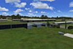
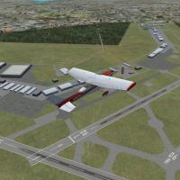
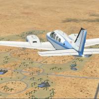
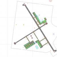
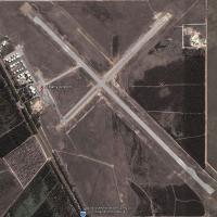
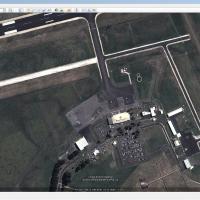
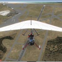
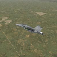
South Australian AFCAD Pack 4 updates Flight Simulator X with revised runway geometry, accurate taxi links, parking spots and current navaid data for Kingston SE YKIG, Loxton YLOX, Marree, Millicent, Mintabie, Moomba, Murray Bridge, Nullarbor, Oodnadatta, Pinnaroo and related rural strips, enhancing GA circuits, glider activity and outback charter routing.

File Size
11.65 KB
Total Downloads
341
Screenshots
1
Preview screenshot

AFCAD-Scenery For YPPH

FSX AFCAD profile for Perth International (YPPH) refines apron geometry, aligns taxiway links, assigns airline-specific gate codes and updates GA stands, ensuring AI traffic flows match current charts; built for default MS Flight Simulator X scenery and harmonised with Orbx FTX Australia, Ultimate Airport Environment and common traffic packages.

File Size
297.95 KB
Total Downloads
333
Star Rating
4/5
Screenshots
3
Preview screenshot

Devonport

The FSX Devonport add-on overhauls Tasmania’s YDPO with a revised AFCAD, Orbx-friendly autogen, OzX asset integration, corrected runway headings, realistic taxiway signage, dynamic AU Traffic AI, and context-specific ground textures, providing a well-aligned coastal airfield ready for GA sorties and Bombardier Q400 ops.

File Size
2.59 MB
Total Downloads
332
Screenshots
4
No image available.

South Australian Airports Pack 5

Covering 15 South Australian airfields—from Balcanoona’s pastoral strip and Beverley’s uranium-mine runway to Wilpena Pound’s tourism hub—this FS2004/FSX BGL set reworks coordinates, runway markings, parking, windsocks, landclass and basic navaids, supplying bush pilots and regional GA flyers accurate VFR scenery across Eyre Peninsula, Flinders Ranges, Riverland and the west coast fishing towns.

File Size
16.27 KB
Total Downloads
330
Screenshots
4
Preview screenshot

Lismore Regional Airport

FSX scenery package for Lismore Regional Airport YLIS, northern New South Wales, supplies photo-mapped landclass, tuned watermasking and hand-placed GA hangars, Rex overhaul bay and the angular terminal bearing Aboriginal art; the revised AFCAD depicts 52 weekly Sydney legs, suiting circuit training or coastal hops from Ballina and Byron Bay in Microsoft Flight Simulator X.

File Size
5.6 MB
Total Downloads
328
Star Rating
1/5
Screenshots
4
Preview screenshot

RAAF Delamere Weapons Range

Covering roughly half a million remote Northern Territory acres, this FSX rendition of RAAF Delamere Weapons Range repositions YWDF to its true coordinates and adds the central bombing pattern, dummy northern strip, military ramp, fuel stand and revised restricted airspace, all assembled with stock assets via Airport Design Editor.

File Size
282.07 KB
Total Downloads
327
Screenshots
2
Preview screenshot

Red Bull Air Race Perth

FSX users will find this freeware scenery mod replicates the 2010 Red Bull Air Race course above Perth’s Swan River, inserting inflatable gates, marker buoys, event barges and CBD skyline autogen in correct coordinates for realistic line-abreast flying. Lightweight textures and optimized polygons preserve FPS while practising knife-edge turns and rapid vertical pull-ups across Western Australia.

File Size
568.89 KB
Total Downloads
326
Screenshots
1

5 pages with 99 downloads.

previous12345next