Australia

Page 4

Sort
Reset
No image available.

Brisbane West Wellcamp Airport

Serving Toowoomba and Queensland’s Darling Downs, this Brisbane West Wellcamp Airport (YBWW) add-on supplies FSX with precise runway and taxiway geometry, dual-direction ILS/DME, four stand-coded gates and GA parking, aligning nav-data, approach plates and ground markings for refined regional jet and turboprop operations.

File Size
3.18 KB
Total Downloads
585
Star Rating
1/5
Preview screenshot

Ants Aussie Airports Vol. 1

Covering Cooma-Snowy Mountains (YCOM), Polo Flat, Tumut (YTMU), Khancoban (YKHA), Geehi and Adaminaby’s Kennedy Field (YADY), Ants Aussie Airports Vol. 1 supplies FSX with high-resolution photoreal ground polygons, bespoke 3-D assets and updated AFCAD data, harmonised with ORBX FTX Australia for realistic bush, GA and charter workflows.

File Size
33.19 MB
Total Downloads
569
Preview screenshot

Parafield Airport

Covering Parafield Airport (YPPF) near Adelaide, this FSX/Acceleration scenery from Roger’s Aussie Scenery refines runway geometry, parallel taxi systems and GA ramp layouts, aligning objects with Google Earth data for realistic circuit training, VFR patterns and touch-and-go practice while retaining smooth frame rates on Windows XP-era hardware.

File Size
347.46 KB
Total Downloads
527
Star Rating
2/5
Screenshots
1
No image available.

Kingsford Smith International

FSX adaptation of Sydney’s Kingsford Smith Intl (YSSY) refreshes the default layout with ADE-built crosswind runway 07/25 logic, full three-runway traffic flow, Gate 57 sized for A380, expanded stands and assigned parking bays, active fuel bowsers, rebuilt service roads, illuminated helipad and tower-cam viewpoint for realistic Australian hub operations.

File Size
99.89 KB
Total Downloads
512
No image available.

YSSY Sydney AFCAD

This updated AFCAD for YSSY Kingsford Smith refines gate numbering, airline-coded stands and jetway alignment drawn from Google Earth overlays and Airservices Australia AIP charts, ensuring precise AI traffic flow and accurate radius assignments for FSX-Acceleration users running FTX AU traffic, WOAI or comparable schedules.

File Size
50.72 KB
Total Downloads
497
Preview screenshot

Perth International Airport YPPH

Perth International Airport (YPPH) for FSX refreshes Australia’s western gateway with updated AFCAD layouts, optional crosswind-enabled Runway 06/24, corrected gate numbering, extended vehicle service roads, added helipads, an extra animated jetway and AI-traffic-friendly hold-short nodes along Taxiway W, bringing realistic ground flow without impacting Ultimate Traffic or WOAI schedules.

File Size
24.08 KB
Total Downloads
484
Preview screenshot

Broken Hill Photoreal

Hi-resolution photoreal tiles render Broken Hill’s arid township, surrounding BHP mining leases and the Royal Flying Doctor Service base with 1-m aerial imagery for FSX; package includes an updated AFCAD for YBHI yet omits autogen, leaving simmers free to layer custom vegetation, objects or vector data as desired.

File Size
115.76 MB
Total Downloads
478
Screenshots
5
No image available.

Alice Springs Photoreal

Covering YBAS and adjacent township, this FSX photo-realistic package by David Sheridan lays high-resolution satellite textures across Alice Springs, Outback Northern Territory, plus a nearby unidentified desert strip at S23°41.72' E133°56.63', ideal for VFR practice over Australia’s red-centre. No autogen included; freeware files remain open for user enhancement.

File Size
99.99 MB
Total Downloads
449
No image available.

Queensland Airports Pack One

Covering Augustus Downs, Adels Grove, Aramac, Alpha, Arrabury, Atherton, Aurukun, Ayr, Barcaldine and Badu Island, this FSX scenery package refines runway layout, apron geometry and nav data for ten remote Queensland aerodromes, using AFX edits drawn from Google Earth overlays and Australian Airservices charts for reliable VFR and bush-flying operations.

File Size
10.46 KB
Total Downloads
439
Preview screenshot

Jandakot Airport

This FSX add-on recreates Jandakot Airport (YPJT), Western Australia with geo-referenced runways, custom taxiway layouts, photoreal structures and accurately positioned GA ramps drawn from Google Earth data, giving VFR pilots a reliable training hub that integrates cleanly with FSX Acceleration on Windows 64-bit systems.

File Size
4.55 MB
Total Downloads
436
Star Rating
1/5
Screenshots
1
Preview screenshot

YBMK

Refreshed AFCAD for YBMK – Mackay Airport, Queensland, brings current apron geometry, expanded stands, correct gate designations, added SAR helipads and accurate fire station placement, plus revised taxi node logic so AI traffic holds the centerline on 14/32; compatible with FSX and Prepar3D, suited to domestic jet and rotary-wing operations.

File Size
68.28 KB
Total Downloads
371
Screenshots
1
No image available.

Coffs Harbour

FSX Coffs Harbour (YSCH) for Australia revamps this New South Wales airfield with XML-driven architecture, photo-sourced Mutton Bird Island, reshaped shoreline from Sawtell to Woolgoolga, corrected landclass, detailed retail precincts and the Big Banana landmark, balanced to keep frame rates acceptable on older single-core hardware.

File Size
12.03 MB
Total Downloads
366
No image available.

YSSY ILS Fix

Targeted adjustment calibrates the ILS localizer and glideslope on runway 16L at Sydney–Kingsford Smith (YSSY), delivering accurate CAT I approaches within default Microsoft Flight Simulator X SP1 scenery; this Australia-specific nav-aid correction removes the lateral offset and supports reliable autopilot capture on final.

File Size
23.62 KB
Total Downloads
346
No image available.

Rottnest Island

Rottnest Island for FSX refreshes Perth’s offshore playground with high-resolution photoreal terrain derived from satellite imagery, upgraded autogen vegetation, custom default-library structures, moving AI boats matched to real moorings, fictional oil rigs and roaming wildlife Easter eggs; the compact YRTI strip remains tuned for light GA and turboprop traffic.

File Size
11.84 MB
Total Downloads
343
No image available.

South Australian AFCAD Pack 4

South Australian AFCAD Pack 4 updates Flight Simulator X with revised runway geometry, accurate taxi links, parking spots and current navaid data for Kingston SE YKIG, Loxton YLOX, Marree, Millicent, Mintabie, Moomba, Murray Bridge, Nullarbor, Oodnadatta, Pinnaroo and related rural strips, enhancing GA circuits, glider activity and outback charter routing.

File Size
11.65 KB
Total Downloads
342
No image available.

South Australian Airports Pack 5

Covering 15 South Australian airfields—from Balcanoona’s pastoral strip and Beverley’s uranium-mine runway to Wilpena Pound’s tourism hub—this FS2004/FSX BGL set reworks coordinates, runway markings, parking, windsocks, landclass and basic navaids, supplying bush pilots and regional GA flyers accurate VFR scenery across Eyre Peninsula, Flinders Ranges, Riverland and the west coast fishing towns.

File Size
16.27 KB
Total Downloads
332
Preview screenshot

RAAF Delamere Weapons Range

Covering roughly half a million remote Northern Territory acres, this FSX rendition of RAAF Delamere Weapons Range repositions YWDF to its true coordinates and adds the central bombing pattern, dummy northern strip, military ramp, fuel stand and revised restricted airspace, all assembled with stock assets via Airport Design Editor.

File Size
282.07 KB
Total Downloads
330
Screenshots
2
Preview screenshot

Lismore Regional Airport

FSX scenery package for Lismore Regional Airport YLIS, northern New South Wales, supplies photo-mapped landclass, tuned watermasking and hand-placed GA hangars, Rex overhaul bay and the angular terminal bearing Aboriginal art; the revised AFCAD depicts 52 weekly Sydney legs, suiting circuit training or coastal hops from Ballina and Byron Bay in Microsoft Flight Simulator X.

File Size
5.6 MB
Total Downloads
329
Star Rating
1/5
Preview screenshot

Red Bull Air Race Perth

FSX users will find this freeware scenery mod replicates the 2010 Red Bull Air Race course above Perth’s Swan River, inserting inflatable gates, marker buoys, event barges and CBD skyline autogen in correct coordinates for realistic line-abreast flying. Lightweight textures and optimized polygons preserve FPS while practising knife-edge turns and rapid vertical pull-ups across Western Australia.

File Size
568.89 KB
Total Downloads
328
Screenshots
1
No image available.

Western Australia Airports 2

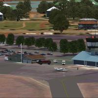
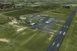
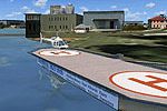
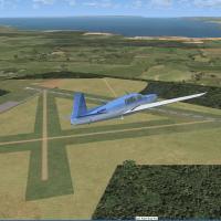
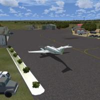
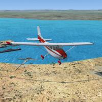
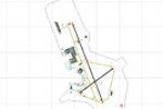
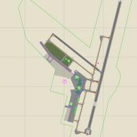
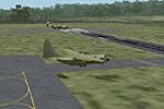
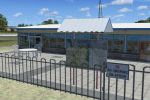
Eight refreshed bush and coastal airfields around Western Australia—Dwellingup, Mylup Estate, Harrismith, Kulin, Pinjarra, Bremer Bay, Abrolhos Islands and Murray Field—feature in this FSX freeware scenery, authored with ADE and FSX-KML. Y-prefixed ICAO codes, photoreal ground polys, dirt or gravel strips, corrected taxi routes and nav aids suit outback wheatbelt hops, south-coast VFR touring and GA training sorties.

File Size
32.66 KB
Total Downloads
319
Star Rating
5/5

5 pages with 99 downloads.

previous12345next