Page 30
Searches the whole library — filter by sim & category on the results page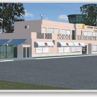
By José Maia, the Coimbra airfield enhancement covers a 20×20 km area and uses new mesh data with refined ground imagery to mirror the region’s landscape, while depicting enhanced runway markings a…
 Portugal
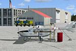
Jim Cook expands Robins Air Force Base (ICAO KWRB) by adding Military_Cargo and Military_Combat parking positions and a new fire station with emergency vehicles. The deployment uses AFX_KWRB_JC.bgl…
 United States of America
Konrad Ell depicts Freiburg Airport (EDTF) and the Black Forest region in Germany, presenting an EDTF.bgl file and objects such as a balloon, sheep, buildings, birds, people, and a theme park in a …
 Germany
The ILS frequency for SKBO runway 13L is 111.3 MHz, aligning with current specifications at Bogota's international airport. The file comes as a single bgl, by Juan Carlos Cancelado R, with a warnin…
 Colombia
Jim Cook delivers an add-on that places a detailed Boeing manufacturing facility and the Kansas Aviation Museum near McConnell AFB, adds comprehensive Military_Cargo parking, and replaces select ha…
United States of America
CYND Gatineau Airport near Ottawa, Ontario, is version 1.0 credited to Pierre Gallant of Concepteurs Virtuels du Quebec. The cyndv10.zip archive expands into a cynd directory with two subfolders an…
 Canada
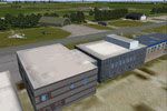
NL2000 v4.03 add-on recreates the base at Leeuwarden in Friesland with custom ground polygons and updated taxiway configurations, designed to integrate into the NL2000 v4 framework. It relies on th…
 Netherlands
Two airports in Itanhaem, SDIM and SDCR, receive v2.0 work by Ren Scen, providing runways, taxiways, parking positions, and buildings for the town in Brazil. A single .BGL file is used and it impro…
 Brazil
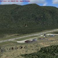
Castlegar Airport in British Columbia receives a patch by P. Nigel Grant that adapts Vern Opperman’s CYCG_V2.ZIP for use with cyxc04.zip. The accompanying archive supplies four bgl files to place i…
Canada
Woensdrecht base appears in the NL2000 v4 lineup, detailing apron layouts and essential facilities to mirror real operations. It relies on the v4.0.32 installer and aligns runway coordinates and or…
Netherlands
The airfield sits near La Llagonne at the edge of the Pyrenees in France, offering rough terrain beside a large lake and a region rich in thermals. Registration is LFNQ, and it is not compatible wi…
 France
Lake Hood's area near Alaska gains added hangars, animated floatplanes, docks, buildings, and land vehicles, by Daniel Kemmer. It uses Lakehood.bgl and Lakehoodparking1.bgl, and viewers see full de…
United States of America
Ray Smith delivers a revised KMKE representation, featuring expanded runways, added gates and a functional jetway system, plus a helipad and refined roadways. Two crosswind-capable variants exist a…
United States of America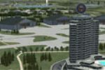
Two configurations render Lahr (EDTL) with enhanced facilities, including a variant aligned for standard terrains and another for the VFR Germany environment. Peter der Ostfriese and Jürgen Seidel …
Germany
OpenStreetMap-based data drives a Netherlands-focused POI project that populates roads, railways, waterways, land use, and natural elements for detailed navigation across the country. Created by Ma…
NetherlandsIn Tibet, Nyingchi Airport (ZUNZ) carries IATA LZY and ICAO ZUNZ, sits at 2,949 meters above sea level with a 3,000-meter asphalt runway, coordinates N29°18'13" E94°20'06", and runway 05/23. The au…
 China
China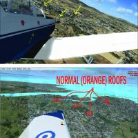
By Vassilis Kostoulas, the work corrects blue rooftop tones observed in Greek settings, replacing them with orange roofs to reflect a regional color shift. It notes the mediterranean_east area and …
 Greece
Situated in the Vendee region of western France along the Atlantic coast, the airfield features grass and asphalt runways and welcomes general aviation and parachute events. By Dominique M. L. Donz…
France
A model of Patoka AO-9 sits at anchor as a mooring mast docking platform across five geographic locations, with airports MPAO Panama Roads, KNAO Pensacola Bay, KAPO Narragansett Bay, VGAO Old Plant…
 Global (World)
Angers-Marce LFJR v4, created by Theo Madzou, centers on Angers-Marce Airport in France and its surrounding area. It includes the airfield and nearby terrain, while noting that the tanker car and p…
France