 FSX Scenery
Terrace Airport (CYXT)
Situated in British Columbia’s scenic northwestern region, Terrace Airport (C…
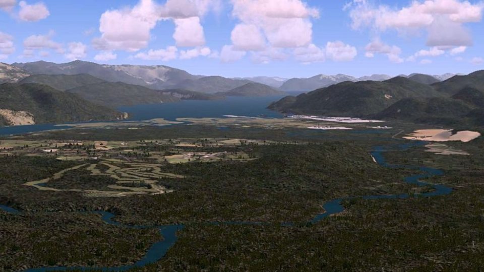
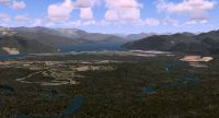
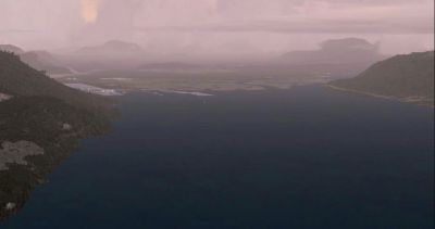
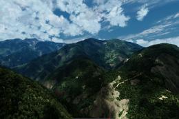
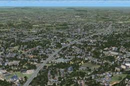
Kitimat and Terrace, British Columbia scenery brings the Douglas Channel and inland valleys to life with detailed rivers, lakes, highways with moving traffic, and floatplane docks, plus a rugged sloped mountain strip and lookout. Built for FSX, it also enhances local airports and key navaids, supported by high-resolution terrain mesh.


Kitimat/Terrace, British Columbia, Canada. The coverage area for this scenery is about as far south as the Sioux Channel south of Kitimat, as far north as the top end of Kalum Lake, west to 129W and east to 128W. Most of the more important rivers, lakes, and creeks are featured in the scenery. By Douglas Keech.
Kitimat/Terrace Scenery.
Thank-you for your interest in downloading and trying this scenery add-on for FSX. To install, simply extract all the bgl files into your addon Scenery folder then restart fsx. Alternatively, you could create new folders such as addon scenery/kitimat/scenery and place the bgl files there. Then, activate them via the fsx scenery library. Any files with the suffix FLT or WX should be placed in the documents/flight simulator X folder. These are situation files.
The coverage area for this scenery is about as far south as the sioux channel south of kitimat, as far north as the top end of kalum lake, west to 129W and east to 128W.
Most of the more important rivers, lakes, and creeks are featured in the scenery. The main rivers are the Kitimat, the Skeena, the Lakelse (my favorite fishing river in the whole world), the Copper, the Little Wedeene, the Big Wedeene, and the Kalum. Besides the salt water of the Douglas Channel south of Kitimat, the area also features two large lakes - Kalum Lake, and Lakelse Lake.
Many of the important highways and secondary/logging roads are also featured. There are moving vehicles on the highways.
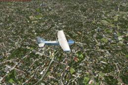
I have placed floatplane docks on lakelse lake, kalum lake, and in the sioux channel. These are ficticious but add to the fun of flying floatplanes in the area. There is also an extremely dangerous mountain landing strip located just west of the kitimat airpark west of iron mountain. It is perched on the mountainside, sloped, and very bumpy. Safe landings are only possible uphill to the south. Takeoffs can be done to the north and south, however due to the strips short length, an aircraft with adequate power is necessary to attain enough speed for an uphill takeoff. Again, this is ficticious but added for the fun of short flights within the area. There is a fire lookout tower above this dirt strip on the top of the mountain.
There are two airports within this scenery area: 1.) the Terrace/Kitimat regional airport which receives Air Canada Jazz dash 8, Hawkair dash 8, and Pacific Coastal Saab 340 aircraft, smaller general aviation aircraft, air ambulance lear jet, and helicopter traffic.
2.) the Kitimat Airpark which serves smaller general aviation aircraft, and ultralight aircraft in the area.
The important navigation facilities of the area are the Kitimat NDB (ZKI 203) located in Kitimat, the Terrace NDB (XT 332) located at lakelse lake, and the ILS for rwy 33 at the Terrace/Kitimat airport (XXT 110.1, course 328, 3.5 degree slope).
I have tried to make the bgl files as modular as possible. This means that other developers can remove certain files and add their own if they so wish. (such as water objects, wildlife etc.)
I have also utilized high resolution (about 21 meter) terrain mesh data throughout the area. I have sampled it in "multi-LOD" to give better frame rates when flying.
This scenery is in no way technically perfect. I do think it is a far cry better than the default scenery for the area however, and I hope you enjoy using it.
This scenery is freeware and may only be distributed as such.
I would like to gratefully acknowledge the creators of google earth, russel dirks (ezlc), and mathew (fsxkml) for your wonderful high level scenery tools, and holger sandmann for your support.
Best Regards,
Doug
Kitimat/Terrace Scenery.
Free for all simmers · 30.95 MB · Scanned clean
Download speed: Free tier is capped at 0.5 Mbps (this file takes approximately 9 mins at the cap). PRO members download at full line speed.
FSX\Addon Scenery\ containing scenery and texture sub-folders.readme.txt or README file. It tells you exactly where files go, what dependencies are needed, and any quirks specific to this add-on.Use these coordinates to fly directly to this location once the mod is installed.
54.46850000,-128.57600000
Launch FSX or Prepar3D and use Flights → Load to open the downloaded .pln file. Your aircraft will be positioned at this location.
The archive kitimatf.zip has 71 files and directories contained within it.
This list displays the first 500 files in the package. If the package has more, you will need to download it to view them.
| Filename/Directory | File Date | File Size |
|---|---|---|
| airpark objects.bgl | 04.17.07 | 924 B |
| alistairlaketerrain.bgl | 04.22.07 | 2.20 MB |
| antennas.bgl | 04.27.07 | 732 B |
| bridgeexclude.BGL | 04.03.07 | 112 B |
| cabins.bgl | 04.06.07 | 348 B |
| chistcreekterrain.bgl | 04.22.07 | 2.17 MB |
| cvx15EXT.BGL | 04.01.07 | 236 B |
| cvx33EXT.BGL | 04.01.07 | 228 B |
| cvxAIRPARK FLATTEN.BGL | 04.16.07 | 1.25 kB |
| cvxAIRPARK FLATTEN55.BGL | 04.16.07 | 227 B |
| cvxAIRPARK FLATTEN65.BGL | 04.17.07 | 227 B |
| cvxAIRPARK FLATTEN72.BGL | 04.17.07 | 227 B |
| cvxAIRPARK NEW POLY.BGL | 04.18.07 | 255 B |
| cvxAREA EXCLUDE.BGL | 05.05.07 | 29.29 kB |
| cvxBIG WEDEENE RIVER.BGL | 05.07.07 | 5.42 kB |
| cvxCABLECAR ROADS.BGL | 05.03.07 | 465 B |
| cvxCOPPER RIVER.BGL | 05.07.07 | 5.17 kB |
| cvxCREEKS.BGL | 05.12.07 | 22.99 kB |
| cvxCYXT POLY.BGL | 04.21.07 | 345 B |
| cvxEXCLUDES.BGL | 05.05.07 | 6.79 kB |
| cvxGOLF COURSE.BGL | 05.03.07 | 2.80 kB |
| cvxHIGHWAYS.BGL | 04.29.07 | 38.15 kB |
| cvxHIRSCH CREEK.BGL | 05.07.07 | 5.12 kB |
| cvxKALUM RIVER.BGL | 05.12.07 | 7.79 kB |
| cvxKILDALA RIVER.BGL | 04.29.07 | 2.12 kB |
| cvxKITIMAT RIVER.BGL | 05.07.07 | 13.21 kB |
| cvxKITIMAT ROADS.BGL | 04.29.07 | 847 B |
| cvxLAKELSE RIVER.BGL | 04.29.07 | 8.21 kB |
| cvxLANDCLASS.BGL | 05.05.07 | 37.85 kB |
| cvxLITTLE WEDEENE RIVER.BGL | 05.07.07 | 2.72 kB |
| cvxMOUNTAIN STRIP.BGL | 05.11.07 | 521 B |
| cvxSECONDARY ROADS.BGL | 05.03.07 | 9.49 kB |
| cvxSKEENA RIVER.BGL | 04.29.07 | 19.85 kB |
| cvxSKEENA TRIANGLE EXCLUDE.BGL | 04.28.07 | 312 B |
| cvxUTILITY LINES.BGL | 04.29.07 | 4.46 kB |
| cvxWATER BODIES.BGL | 04.29.07 | 43.58 kB |
| cyxt objects.bgl | 05.06.07 | 1.78 kB |
| dirt strip objects.bgl | 05.06.07 | 668 B |
| dorreenterrain.bgl | 04.22.07 | 2.03 MB |
| exstewriverterrain.bgl | 04.22.07 | 2.24 MB |
| fochlagoonterrain.bgl | 04.22.07 | 2.23 MB |
| industries.bgl | 04.27.07 | 5.78 kB |
| kalum lake objects.bgl | 05.05.07 | 796 B |
| kildalaarmterrain.bgl | 04.22.07 | 2.16 MB |
| kitimat landclass.bgl | 04.29.07 | 874 B |
| kitimatarmterrain.bgl | 04.24.07 | 1.70 MB |
| kitimatterrain.bgl | 04.22.07 | 2.03 MB |
| kitsumkalumterrain.bgl | 04.22.07 | 1.98 MB |
| lakelseterrain.bgl | 04.22.07 | 1.85 MB |
| mountdaviesterrain.bgl | 04.22.07 | 2.16 MB |
| oscarpeakterrain.bgl | 04.22.07 | 2.15 MB |
| salvusterrain.bgl | 04.22.07 | 2.09 MB |
| terraceterrain.bgl | 04.22.07 | 2.06 MB |
| uskterrain.bgl | 04.22.07 | 2.21 MB |
| water objects douglas channel.bgl | 05.05.07 | 2.03 kB |
| water objects lakelse lake.bgl | 04.29.07 | 988 B |
| wildlife.bgl | 04.28.07 | 2.84 kB |
| readme.txt | 05.12.07 | 3.34 kB |
| Lakelse Lake beaver.FLT | 05.12.07 | 8.66 kB |
| Lakelse Lake beaver.WX | 05.12.07 | 290.29 kB |
| dirt strip takeoff north maule.FLT | 05.11.07 | 8.51 kB |
| dirt strip takeoff north maule.WX | 05.11.07 | 199.77 kB |
| Kitimat airpark maule.FLT | 05.07.07 | 8.50 kB |
| kitimat airpark maule.WX | 05.07.07 | 212.96 kB |
| Sioux Channel beaver.FLT | 05.12.07 | 8.46 kB |
| Sioux Channel beaver.WX | 05.12.07 | 295.48 kB |
| kitimatfsx.txt | 05.12.07 | 308 B |
| kitimatfsx-1.jpg | 05.11.07 | 29.80 kB |
| kitimatfsx-2.jpg | 05.12.07 | 95.26 kB |
| flyawaysimulation.txt | 10.29.13 | 959 B |
| Go to Fly Away Simulation.url | 01.22.16 | 52 B |
More FSX & P3D add-ons hand-picked based on this download.
FSX Scenery
Situated in British Columbia’s scenic northwestern region, Terrace Airport (C…
FSX Scenery
Skara Scenery Bonaire X. Flamingo International Airport or Bonaire Internatio…
 FSX Scenery
Iwo Jima Scenery 1945 Update. This is a complete scenery with added effects a…
FSX Scenery
Kjeller Area Scenery X, Norway. Scenery around Kjeller airport with photoreal…
 FSX Scenery
FSX Loney's Alaska For FSX. This is a compilation of the author's Alaskan sce…
 FSX Scenery
For users of Flight Simulator X (and FSX: Steam Edition) and/or Prepar3D, ter…
 FSX Scenery
This freeware release by developer Aime Leclercq introduces revised highways …
 FSX Scenery
Team GEX Enhanced Autogen World. This package upgrades 522 world wide autogen…
Be the first to leave a comment on this download.
Be the first to share your thoughts on this download.