 FSX Scenery
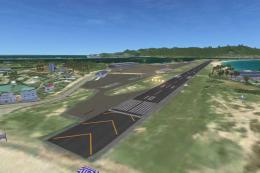
FSX Skara Bonaire X
Skara Scenery Bonaire X. Flamingo International Airport or Bonaire Internatio…
Axalp/Ebenfluh brings Switzerland’s high-altitude Axalp Shooting Range to life in FSX, set at 2,200 meters in the Alps near Meiringen Air Base. The scenery models buildings, targets, navaids, tower viewpoint, helicopter landing pads, animated flags, and static helicopters, and requires FS Global 2008 for terrain coverage.
Scenery Axalp / Ebenfluh, Switzerland. Axalp Shooting Range is unique in its location - 2200m above sea level in the Swiss Mountains, close to Meiringen AB. Each year during October, aviation enthusiasts make the arduous climb to enjoy this very special event. Scenery includes all buildings, targets, navaids, tower view, helicopter landing pads, animated flags and static helicopters. Requires FS Global 2008. By Dave Torkington.
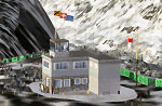
Screenshot of Axalp/Ebenfluh Scenery.
Free for all simmers · 4.32 MB · Scanned clean Jul 2026
Download speed: Free tier is capped at 0.5 Mbps (this file takes approximately 1 min at the cap). PRO members download at full line speed.
FSX\Addon Scenery\ containing scenery and texture sub-folders.readme.txt or README file. It tells you exactly where files go, what dependencies are needed, and any quirks specific to this add-on.Use these coordinates to fly directly to this location once the mod is installed.
46.72000000,8.03000000
Launch FSX or Prepar3D and use Flights → Load to open the downloaded .pln file. Your aircraft will be positioned at this location.
The archive axalpfsx.zip has 5 files and directories contained within it.
This list displays the first 500 files in the package. If the package has more, you will need to download it to view them.
| Filename/Directory | File Date | File Size |
|---|---|---|
| AxalpFSX.gif | 10.21.10 | 14.01 kB |
| AxalpFSX.zip | 10.21.10 | 4.31 MB |
| FILE_ID.DIZ | 10.21.10 | 424 B |
| flyawaysimulation.txt | 10.29.13 | 959 B |
| Go to Fly Away Simulation.url | 01.22.16 | 52 B |
Only PRO members can place votes.
More FSX & P3D add-ons hand-picked based on this download.
FSX Scenery
Skara Scenery Bonaire X. Flamingo International Airport or Bonaire Internatio…
 FSX Scenery
Iwo Jima Scenery 1945 Update. This is a complete scenery with added effects a…
FSX Scenery
Kjeller Area Scenery X, Norway. Scenery around Kjeller airport with photoreal…
 FSX Scenery
FSX Loney's Alaska For FSX. This is a compilation of the author's Alaskan sce…
 FSX Scenery
For users of Flight Simulator X (and FSX: Steam Edition) and/or Prepar3D, ter…
 FSX Scenery
This freeware release by developer Aime Leclercq introduces revised highways …
 FSX Scenery
Team GEX Enhanced Autogen World. This package upgrades 522 world wide autogen…
 FSX Scenery
Princess Juliana International Airport (TNCM) in Saint Marteen, Netherlands A…
Be the first to leave a comment on this download.
Be the first to share your thoughts on this download.