 FSX Scenery
Pocono Mountains Municipal Fix
Pocono Mountains Municipal Airport (KMPO), Pennsylvania (PA). This package co…
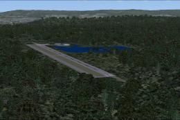
Pocono Mountains Municipal Airport (KMPO) scenery brings Mount Pocono, Pennsylvania to life in FSX with an updated AFCAD reflecting the extended 13/31 runway at 5,001 feet, plus accurate field elevation and local airport detail. Includes default-aircraft AI traffic and requires EZ-Scenery and Rwy12 object libraries for full visuals.
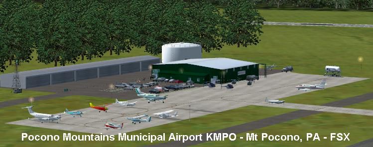
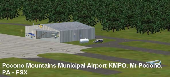
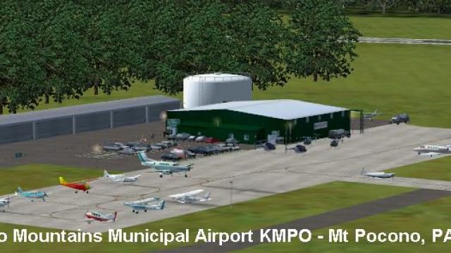
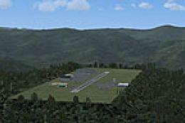
Pocono Mountains Municipal Airport (KMPO) serves Mount Pocono and Monroe County, Pennsylvania (PA) and is owned by Pocono Mountain Municipal Airport Authority. The airport has more than one runway. The longest is a paved runway extending 5001 feet. The facility is at an elevation of 1916 feet at a distance of about 2 miles from Mount Pocono. Includes the runway 13/31 which was extended to 5001 ft x 75 ft. By John B. Loney, Jr.
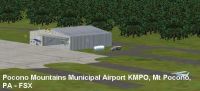
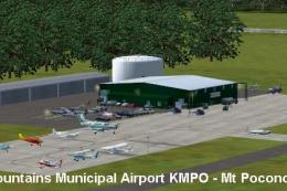
Screenshot of Pocono Mountains Municipal Scenery.
WHAT YOU NEED:
You may be able to save download time by installing the following two files. If you are still missing textures or objects, then you will have to download the individual library files.
ez_1.zip by David Grindele.
rwy12_1.zip by David Grindele.
loneys_ez_scenery.zip by the author.
The following are the individual library objects you need for this scenery.
fg_fences.zip by Robert Finnegan and Gary Mills.
abwalph3.zip by Scot Ingram.
smlairob.zip by Sidney Schwartz, with animated windsock by Jörg Dannenberg.
ezhangers.zip by Dennis Waggoner.
ezlrghg.zip by Sidney Schwartz.
lens_ez_scenery.zip and lens_ez_scenery_textures.zip by Len Hickman.
ez-fuelt.zip by Sidney Schwartz.
esdg_ramplight_rwy12.zip by Bill Leaming.
ez-extra-objects-1.zip and ez-extra-objects-1-textures.zip by Lars Hoyer uploaded by Steve Ziegler.
parklrgs.zip by Sidney Schwartz.
park_ss.zip or parking_ss.zip by Sidney Schwartz.
ezgahng2.zip by Sidney Schwartz.
ga_planes_1.zip or gaplane1.zip by Seev Kahn repackaged by Steve Ziegler.
rwy12_lib2_v1.2.zip by Rwy12 Team.
AI Traffic is done with default aircraft. No third party AI aircraft to download.
INSTALLATION:
Since you are reading this file you obviously have already unzipped the zip file pocono_mountains_mun_kmpo_fsx.zip to a temporary folder. Having done so please find the following files.
FILE_ID.DIZ
kmpo_fsx_1.jpg
kmpo_fsx_2.jpg
kmpo_fsx_screenshots.zip
pocono_mountains_mun_fsx_scenery.zip
Readme.doc
readme.txt
Check your file structure in your Windows Explorer. If your FS setup is like the following, then all you need to do is unzip pocono_mountains_mun_scenery.zip to the drive where your FS is located.
:\Programs Files\Microsoft Games\Flight Simulator X.
Using the folder feature in your zip program, the scenery files will be placed in the FS\Addon Scenery folder under KMPO - Pocono Mountain Mun.
Start FSX and navigate to 'Scenery Library' via the 'Settings' menu. Select 'Add Area' and activate the scenery in the usual manner.
If your file structure is not like that mentioned above, then unzip the zip file to a temporary folder and manually move the KMPO - Pocono Mountain Mun folder to wherever you keep your add-on scenery, then activate the scenery in FSX.
All AI Traffic uses default aircraft only.
Enjoy your flights.
ABOUT THE AIRPORT:
Pocono Mountains Municipal Airport (KMPO) serves Mount Pocono and Monroe County, PA and is owned by Pocono Mtns Muni Arpt Auth. The airport has more than one runway. The longest is a paved runway extending 5001 feet. The facility is at an elevation of 1916 feet at a distance of about 2 miles from Mount Pocono.
Airport Operational Statistics:
Aircraft based on the field: 20
Single engine airplanes: 16
Multi engine airplanes: 2
Helicopters: 2
Aircraft operations: avg 54/day *
66% local general aviation
33% transient general aviation
2% military
* for 12-month period ending 03 September 2010
ABOUT THE SCENERY:
Another small airport for your flying pleasure. While flying around in FS9, I just happened to land at this airport. So, I added it to the list and now, I finally got to design it. FS had the 13/31 runway's length at 4000 ft, but it has been extended to 5001 ft, therefore I modified the AFCAD file to reflect that update. After designing the FS9 version, I then decided to create the FSX version.
I hope you enjoy this scenery.
THANKS TO:
The above-mentioned authors for their scenery objects. If I have missed anyone, I sincerely apologize and hope the oversight is forgiven.
All the Flight simmers who have flown my scenery and aircraft designs.
This scenery is freeware. You do not have my permission to make any monetary gain from this scenery. It started out as freeware and it shall remain freeware.
I do not accept any responsibility for any damage to any system as a result of running this software.
Have fun and enjoy.

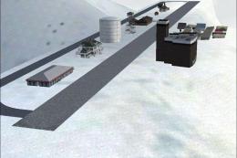
Screenshot of Pocono Mountains Municipal Scenery.
Free for all simmers · 738.75 KB · Scanned clean Jul 2026
Download speed: Free tier is capped at 0.5 Mbps. PRO members download at full line speed.
FSX\Addon Scenery\ containing scenery and texture sub-folders.readme.txt or README file. It tells you exactly where files go, what dependencies are needed, and any quirks specific to this add-on.Use these coordinates to fly directly to this location once the mod is installed.
41.13780000,-75.37440000
Launch FSX or Prepar3D and use Flights → Load to open the downloaded .pln file. Your aircraft will be positioned at this location.
The archive pocono_mountains_mun_kmpo_fsx.zip has 9 files and directories contained within it.
This list displays the first 500 files in the package. If the package has more, you will need to download it to view them.
| Filename/Directory | File Date | File Size |
|---|---|---|
| readme.txt | 02.22.11 | 7.13 kB |
| FILE_ID.DIZ | 02.22.11 | 413 B |
| kmpo_fsx_1.jpg | 02.22.11 | 53.79 kB |
| kmpo_fsx_2.jpg | 02.22.11 | 40.74 kB |
| kmpo_fsx_screenshots.zip | 02.22.11 | 306.00 kB |
| pocono_mountains_mun_fsx_scenery.zip | 02.22.11 | 36.15 kB |
| Readme.doc | 02.22.11 | 355.00 kB |
| flyawaysimulation.txt | 10.29.13 | 959 B |
| Go to Fly Away Simulation.url | 01.22.16 | 52 B |
Only PRO members can place votes.
More FSX & P3D add-ons hand-picked based on this download.
FSX Scenery
Pocono Mountains Municipal Airport (KMPO), Pennsylvania (PA). This package co…
 FSX Scenery
Birchwood-Pocono Scenery. Birchwood-Pocono was built by the owner of the late…
 FSX Scenery
Rocky Mountains Landclass. The landclass file is a stand-alone scenery. You c…
 FSX Scenery
This freeware package brings an enhanced photorealistic representation of the…
 FSX Scenery
Virginia Mountains Airport Scenery. Number 5 in the series of Pro Hop fiction…
 FSX Scenery
West Coast Mountains. Fictional high-altitude fields at the peaks of several …
 FSX Scenery
30cm Generic Project Textures Rocks Mountains. All rocks mountain around the …
 FSX Scenery
Santa Barbara Municipal Airport (KSBA), California (CA) hi-res photo scenery.…
Be the first to leave a comment on this download.
Be the first to share your thoughts on this download.