Page 2
Searches the whole library — filter by sim & category on the results page
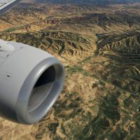
The photoreal coverage spans the Bay Area region and surrounding locales, built from 1/3 arc-second USGS elevation data and orthophotos at zoom level 18. Forkboy2 is the original creator, Fly Away …
Arizona orthophotos fuse USGS elevation data at 1/3 arc-second with overlays, delivering Zoom Level 16 imagery and Zoom Level 17 within four kilometers of airports. Overlay data carries permission …
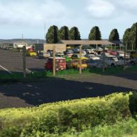
Courtenay Airpark lies adjacent to the city of Courtenay in British Columbia, Canada. Users provide JB_LIBRARY.ZIP, RD_LIBRARY.ZIP, MISTERX_LIBRARY.ZIP, FF_LIBRARY_EXTENDED_LOD.ZIP, and OPENSCENERY…
The Utah orthophoto dataset spans the entire state and supports use in two simulation versions. Fly Away Simulation converts Forkboy2 imagery to DDS, and it arrives pre-compiled in DDS format, elim…
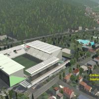
Gunther Kremp presents a Black Forest eastern region enhancement that adds hand-placed 3D landmarks and village clusters across tiles +47+008 and +48+008, drawing on community models to improve low…
Adjacent to Tofino Harbour in British Columbia, Canada, this water aerodrome asset sits along the rocky shoreline. Canada4XPlane delivers it, requiring five libraries—RD_LIBRARY.ZIP, JB_LIBRARY.ZIP…
Canada4XPlane depicts a Comox-area project centered on Canadian Forces Base Comox, near Comox, British Columbia. It relies on libraries such as CDB_LIBRARY.ZIP, JB_LIBRARY.ZIP, RD_LIBRARY.ZIP, and …
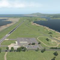
Canada4XPlane delivers an Alberni Valley Regional Airport enhancement, located 6 nautical miles northwest of Port Alberni, British Columbia. It requires CDB_LIBRARY.ZIP, JB_LIBRARY.ZIP, FF_LIBRARY_…
Belem Novo Airfield, ICAO SSBN, serves Porto Alegre and is administered by ARGS for instruction flights, gliders, and aerobatics. The depiction adds corrected aprons, taxiways, gates, lighting, and…
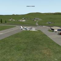
Located on Islay, the airport sits 4.5 NM north-northwest of Port Ellen in Argyll and Bute, off the coast of Scotland, a rural field owned and maintained by Highlands and Islands Airports Limited. …
By Bjoern Meier, the object array adds features across Switzerland for VFR flying, including the Thun train station, Bundeshaus in Bern, and Kapellbrücke in Luzern. Interlaken and Palais Nation nea…
Dundee sits 3 km from the city centre on the Firth of Tay, with its shoreward position overlooking the Tay Rail Bridge. By Paul Mort, the project uses Custom Objects and multiple libraries, includi…
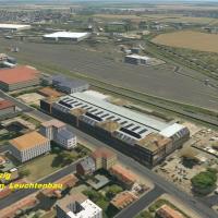
Gunther Kremp presents a freeware rendition of Leipzig and surrounding German towns, highlighting Dessau, Oranienbaum, and Wittenberg in careful 3D form. The work relies on FF Library Extended Vers…
A 3D object environment covers the western Black Forest and coordinates +47+007 and +48+007 in Germany, for VFR flights to heighten realism, by Gunther Kremp. It relies on FF Library Extended (FF_L…
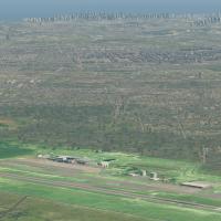
DAESP operates SBSR, serving Sao Jose do Rio Preto, Brazil, and the offering delivers corrected aprons, ramps, gates, taxiways, lighting, and surrounding city buildings. It provides two variants at…
Located 2 nautical miles southwest of Bunbeg in Carrickfinn, The Rosses, northwest County Donegal, Ireland, the airport sits. The runway shifts from a grass strip to a hard surface in the late 1980…
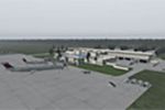
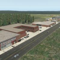
By LKP Designs, KGNV, Gainesville Regional, the project presents a complete remake with all airport buildings modeled after real life structures and taxiway signs modeled after real life, while tra…
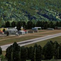
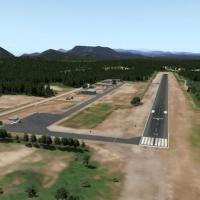
Located along the Skagit River in northern Washington, Mears Field sits south of Lake Shannon. The field has a short paved runway with high trees at both ends, hosts Fairchild, Luscombe, and Waco m…
Two versioned configurations labeled v1.1.0 cover SBMO/MCZ at Maceia in Brazil, including corrected aprons, ramps, gates, and taxiways paired with an ortho photo layer for the surrounding area, plu…
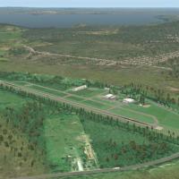
Forestville’s CYFE project presents a 3D representation featuring a single asphalt runway 09/27 length 5,000 feet and an elevation of 293 feet. The file Canada_QC_CYFE by Charles Macelli animates A…