Page 82
Searches the whole library — filter by sim & category on the results page
Soacha VOR provides navigation for Colombia and does not come with default setup in the environment, with attribution to Juan Carlos Cancelado R. This standalone facility, dedicated to the location…
 Colombia
Munich's EDDM receives a total makeover with assigned parking and a lighted helipad, designed with ADE v1.37. A single EDDM.BGL file renders the changes for the default layout, and tower-view persp…
 Germany
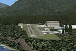
Fourth in the Pro Hop lineup, this Oregon-focused arrangement features nine default fictional airfields across the mountains and Portland area, created by J. D. Starseed and distributed for Red Eye…
 United States of America
By Alexandre Remy, the Rochefort region at LFDN in France presents sound animations that respond when the environmental parameter sits at 50 percent. Buildings are produced with GMAX and optimized …
 France
Manuel Seiwald crafts a focused upgrade for Milos Airport (LGML) in the Cyclades, adding turning bays, a larger apron, and tailored terminal buildings to reflect local architecture and the island’s…
 Greece
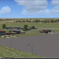
Upington Airport in South Africa, identified as FAUP, is freeware, and its layout includes custom designed buildings alongside default objects, while boasting the longest runway in South Africa, cr…
 South Africa
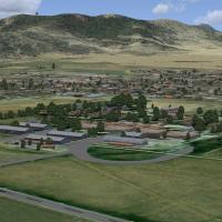
Jacques Botha presents Queenstown, a small GA airfield in South Africa's Eastern Cape, and two concrete items accompany it: a folder named FAQT_Queenstown and a file titled AFX_FAQT_ALT.bgl, reflec…
South Africa
An Ireland location at Donegal presents a rebuilt layout featuring a new terminal and control tower, static aircraft staged for maintenance or departure, alongside a car park with 3D cars and a sur…
 Ireland
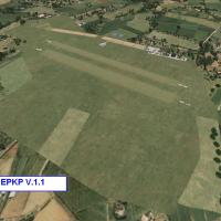
Pobiednik Wielki airfield, coded EPKP in Poland, appears in version 1.1 authored by Dawid Ploskonka. A folder named EPKP-Pobiednik Wielki contains the data, and it anchors references to the airfiel…
 Poland
Edmonton's downtown CYXD in Alberta, Canada, stands at version 1.0 with runway and taxiway closures that free up space for parking where it exists in reality. CYXD removes the ILS approach for runw…
 Canada
Plattsburgh International Airport (KPBG) in New York sits on Lake Champlain between New York and Vermont, where the update replaces most default buildings and adds a fire station, tower, parking, a…
United States of America
Block Island lies in Rhode Island, a small island in Long Island Sound, and this project relies on Flight1's UT-FSX_Usa utility to place objects, while remaining viewable without requiring the acco…
United States of America
SVJM in Venezuela presents a photo-terrain layout based on satellite imagery for a small regional airfield serving the Central Llanos. It includes terminal buildings and hangars with realism that c…
 Venezuela (Bolivarian Republic of)
By Patrick Finch, KSAT replaces the two passenger terminals with custom buildings and adds jetways to every gate, ensuring all gates are equipped and the layout reflects a modernized airfield plan.…
United States of America
Frits Beyer depicts two power stations near Johannesburg in South Africa, Orlando and Soweto, in a two-image set that does not represent real facilities. Orlando lies west of the city’s internation…
South AfricaVasil Dimitrov delivers a fix for Varna Airport add-on, a freeware project, signaling ongoing attention to a small but notable improvement for the Varna installation. Dimitrov authors the fix for t…
 Bulgaria
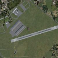
Cardington airfield at EGRA near Bedford, UK, reflects operations dating from 1917 to 1938 and depicts the 1928 layout with Hangar 1 housing the R101 while Hangar 2 remains empty, and the asphalt m…
 United Kingdom
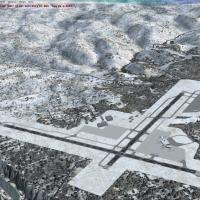
KCRW X variant at Yeager Airport in Charleston, WV adds GA hangars, a terminal replacement, parking, jetways, and lights, using Google Earth imagery to place gates and requiring RWY12 libraries. Fi…
United States of America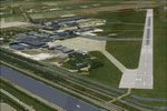
Using the NL2000 framework, designers present Den Helder’s EHKD with dual civilian and military operations, including hangars and rotorcraft parking spots along a North Sea coastline. The v4.02 rel…
 Netherlands
Jimmy R. Martin depicts Sedona Airport in Arizona, code KSEZ, with precise building placement and lighting. The file gaplane1.zip is credited to Steve Ziegler and relies on Scruffy Duck Airport Des…
United States of America