Page 89
Searches the whole library — filter by sim & category on the results page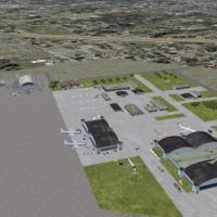
The airfield in Mobile, Alabama, known as KBFM, features two folders authored by Jimmy R. Martin. John L. Woodward's 2004 design provides the detailed buildings, and MOBLBRKL.ZIP must accompany the…
 United States of America
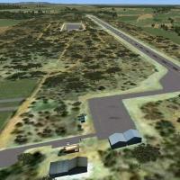
Three airstrips in northwestern South Africa anchor this add-on, including Batavia AW15, Dwaalboom FADB, and Ellisras Lephalale FAER, with Ellisras presented in photoreal detail. Developed by Marti…
 South Africa
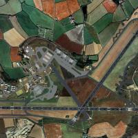
Tony Meredith delivers a RAF Brawdy installation for Horizon GenX Photo assets paired with GenX Mesh, positioned at N51 53.08 W005 07.23. The package includes RAF Brawdy EGDA.bgl, cvxMasteregda.bgl…
 United Kingdom
An asset representing Lincoln Cathedral is placed at the Lincoln location, using a Canterbury Cathedral reference, aligning with a VFR layout. SBuilderX 3.13 places the object and compiles a BGL, w…
United Kingdom
Version 2 refines taxiways and parking at KSAC in California, and removes a mislocated flashing beacon near the southern fuel station, by Phillip Coyle. Airport Design Editor shapes KSAC_ADE_FIX.BG…
United States of America
Version 1.0 centers on Mt. Ena, Magome, Tumago, and Nakatugawa-City in Gifu, with RJNG (Gifu) noted among its coverage, and is credited to Kenichi Ochiai. It highlights geographic scope within cent…
 Japan
Japan
By Lewis Mann, the Shawbury edition centers on helicopter operations, presenting numerous helipads along with hangars and jet parking spaces. It relies on design details from a friend and Rwy12 lib…
United Kingdom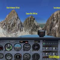
By Frank, this ItalVFR-oriented addon for the Trentino region uses real images captured by a local pilot to reproduce the Sassolungo peaks with 2 m photorealistic detail. It uses an advanced produc…
 Italy
Italy
KGSO in North Carolina receives a thorough revision featuring repositioned taxi lanes and links to R5L, the dedicated FedEx runway, by Jimmy R. Martin. At night, street lights cross near R5L, and t…
United States of America
Two bgl files exist for this SASA project in Salta, Argentina, with charts covering airport, SID, STAR, and IAC. Cristóbal Laje is credited in 2009, and the work remains freeware with artificial li…
 Argentina
A carrier formation near Oceana NAS updates to version 2.0, adding arrestor cables, choppers on deck, and navaids. Located 12 nm northeast of Oceana NAS, it lists a 401.0 NDB with 100 nm range and …
United States of America
An Alaska waterway adjustment repositions Wilson Lake AK to its correct position and size, and redraws Wilson River to blend with the surrounding mesh and terrain features. The river widens and bec…
United States of America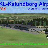
Two editions of EKSS enable Kalundborg’s real-world layout, including EKKL for the Default version and EKKL for DAN-VFR Danish photo coverage with Ultimate Terrain Europa X, accessed via the EKKLX.…
 Denmark
By transforming Paul Clawson's Saratoga model from a static object into a movable AI carrier, this tweak adds a World War II era vessel with AIShips and Arrcab 2.6 integration. The operation relies…
 Global (World)
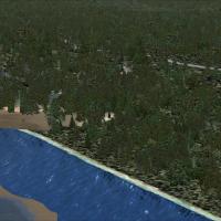
Located on an ocean beach near Copalis Beach in Grays Harbor County, Washington, the airport bears FAA LID S16 and stands as the only U.S. facility on an ocean beach. Its runway comprises a 4500-fo…
United States of America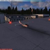
KPWT in Washington, by TimTom Productions, depicts a FBO, hangar, cargo parking, glider club, and animated figures, with a bear behind runway 19 and a hot air balloon above the field. The file requ…
United States of America
Version 1.1, called Flores Upgrade, targets Flores Airport (SWFN) in Manaus, Brazil, and replaces the old version; the nearby Ponta Pelada Airport (SBMN) marks the general area. The airstrip serves…
 Brazil
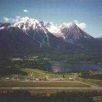
Joe Solomon crafts an accurate approximation of CYYD, a British Columbia airport serving the Smithers area, using an object placement tool. A compiler converts XML mission files to a permanent bgl …
 Canada
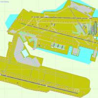
Indira Gandhi International Airport (VIDP) in India has a taxiway network laid over a satellite image. AIP data guides 11-29 navaids, and T2 plus the cargo terminal move south to their actual posit…
 India
IndiaAt Atlanta’s KATL, a Delta hangar project resides, created by Tyler Newport. It bears a license that prohibits profit use without the creator’s consent, and it ties to Georgia, establishing its geo…
United States of America