Page 109
Searches the whole library — filter by sim & category on the results page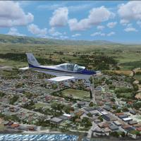
Two towns, Alexandra and Clyde Central Otago, are designed for VLC-Vector Land Class New Zealand coverage and fully autogened. The setup works in a default flight-simulation environment with reduce…
 New Zealand
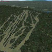
Creators Jean St-Cyr and Gilles Gauthier present a Gaspé Peninsula enhancement with wind turbine clusters, alpine ski centers near Mont Castor and Mont Béchervaise, Cap Gaspé Lighthouse, and Perce …
 Canada
Ken Peters presents CAT4 – Qualicum Beach, a detailed model of the regional aerodrome on Vancouver Island with carefully placed structures and updated landclass data that capture forested and logge…
Canada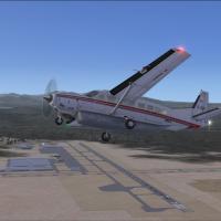
Phillip Coyle provides a freeware enhancement for Truckee-Tahoe Airport, designated KTRK, upgrading runways, taxiways and on-site structures with default library objects and Google Earth alignment …
 United States of America
Plymouth EG51 sits off the coast near Plymouth, UK as a static start point for EH101 operations. It can theoretically be catapult enabled and remains reachable from anywhere via a locatable airport…
 United Kingdom
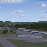
Lihue Airport PHLI in Hawaii gains a fictional enhancement that adds buildings, aircraft, and spawnable helipads, created by Steven Dean with ADE and a shortcut utility; it builds on default surrou…
United States of AmericaTwo BGL variants exist for KTPA, one with crosswind runway activation and one without, named KTPA_ADE_CW_RS.BGL and KTPA_ADE_RS.BGL. ADE v1.37 enables updates to airside C and E, adds a baggage fac…
United States of America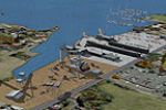
This modification, by Smith Graphics, makes the visuals from the original Microsoft design observable in free flight, extending the scenario’s content beyond its initial use. The change adds an FFM…
United States of America
NZVM at Mokoia on New Zealand's North Island Taranaki coast forms the focus of an adaptation by Godfrey Tier for the Contact Energy Rimu Gas Production Facility and Airstrip. Credits go to Lawrie R…
New Zealand
Revisions of Ithaca-Tomkins County Airport (KITH) in New York adjust aprons, taxiways, and roads and add a new terminal with gates and a jetway. The modification replaces the control tower and most…
United States of America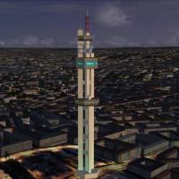
Lukasrand Telkomtower, located in Pretoria, South Africa, is created by Frits Beyer and based on photographs circulating online near the Voortrekker monument behind Swartskop AFB. The Lukasrand Tel…
 South Africa
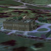
Doncaster’s Brodsworth Hall in the United Kingdom appears in the Castles and Halls series and uses a 2.4-meter/pixel terrain mesh at 5-meter/pixel resolution. English Heritage maintains the freewar…
United Kingdom
Version 2 adds aprons, parking spaces, taxiways, and other objects, while correcting runway markings at the site. Freeflight International Airport, previously Dyess Army Airfield, sits on Roi-Namur…
 Marshall Islands
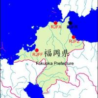
Kasashi Kato presents three variants for Fukuoka Prefecture, Japan, incorporating Fukuoka Airport RJFF and JASDF Ashiya RJFA and Thuiki RJFZ. All three bases carry distinct identifiers RJFF, RJFA, …
 Japan
Japan
Phillip Coyle provides two BGL files, PHMK_ADE.BGL and PHMK_ADE_CVX.BGL, and uses Airport Design Editor to adjust PHMK near Kaunakakai, Hawaii, refining runway length and width, taxiway connections…
United States of America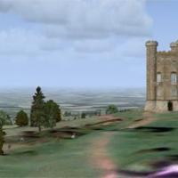
New Version features bump mapping and DDS images for Broadway Tower, enabling closer, more detailed views. The site sits at the top of Fish Hill along the A44 near Moreton in Marsh, coordinates N52…
United Kingdom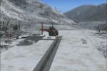
Lillooet Airport (CAR3) in British Columbia appears as an enhanced fictitious depiction by Bob Caparoula, with the file name Lillooet_CAR3.zip and freeware status. The author notes a frame rate fre…
Canada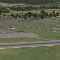
The collection covers four airfields used by the Tuskegee airmen during WWII, including Sharpe Field (AL73), Moton Field (06A), Griel Field (KGRL), and Shorter Auxilary Field (KSHO), with a PT-13 m…
United States of America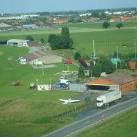
Grass Moorsele EBMO sits in West Flanders, Belgium, fixed at its exact location. Three elevation options—20 m, 18,90 m, and 17 m—exist as .bgl files for Moorsele EBMO, authored by Weygantt Kurt, an…
 Belgium
Redlands Municipal Airport, formerly L12 and now KREI, lies near Redlands, California. The project uses photoreal ground polygons with integrated objects and aerial imagery, while surface appearanc…
United States of America