Page 6
Searches the whole library — filter by sim & category on the results page
By Claus V. Holmberg, this package includes VC-RAIN visuals, Autogen Trees all seasons, and Water and Sky visuals. It is optimized for SP2, reduces sizes and converts some items from 32-bit to DXT3…

Four Gmax generated cumulus clouds mark thermals, with each thermal randomly selecting one of the four variants, by Ed Dumas Sr. AirObjectVisuals.xml accompanies the data, and a reference image sho…
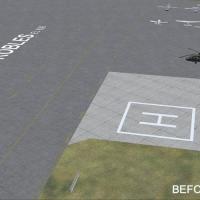
By Al Wheeler and Miguel Zafra, revised asphalt and concrete taxiway and ramp surface imagery removes expansion joint lines from the concrete variant, reduces brightness, and the taxiway_marks.dds …

Ted Porter authors a PDF tutorial detailing the 757 cold and dark startup, version 1.04. Readers save the file to a chosen location and use Adobe Reader to view or print. It stays concise, focusing…
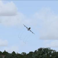
By Tom Tiedman, Tinmouse II provides a smoke system for the 737-200ADV, version 1.25 (TINMOUSE_II_V1_25.ZIP). The archive comprises Aircraft, Docs, Effects, and Modules folders, with Docs and Effec…
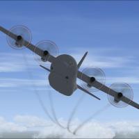
Tom Tiedman provides a dedicated engine smoke configuration for the Premier Aircraft Design Lockheed C-130J-30, identified by the C130J30_4X.ZIP file. The configuration defines four smoke points vi…
By Tom Tiedman, this engine smoke effect targets the Thomas Ruth Airbus A340-200, 300, 500, and 600. It uses the fx_smoke_f6 element and four smoke positions defined in the [SMOKESYSTEM] lines to p…
By Travis Smith, this code adds more views beyond the views that come with the aircraft, presenting a straightforward means to augment observer engagement. Travis Smith authors the work and holds a…
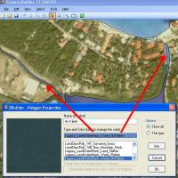
An illustrated guide outlines terrain concepts and how to change them with SBuilder, a tool used to shape island terrain. It covers creating water bodies, roads, vehicle traffic, airport flattening…
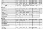
An Excel spreadsheet and a PDF version compile most of the essential options, totaling about 49 significant adjustments to guide frame-rate tuning, By Roger L. Deal. The material prints on two page…
The catalog displays stars down to magnitude 5.50, trimming the total to about 2900 entries and adding planetary data for Mars, Mercury, Jupiter, Saturn, and Venus, with stars arranged by increasin…
Redesigned visuals use DXT5 format and support Service Pack 1, offering a choice of 512x512 or 256x256 resolutions, with added snow, dead leaves, and enhanced palms, improving seasonal variety and …
PDF documents present offline regional airfield data drawn from base .bgl files, organized for quick cross-checks during simulated travel. Global coverage spans Canada, Europe, South America, the U…

By Ted Andrews, over 500 autogen models are converted into an XML look-up file accompanied by JPG previews. Five new Autogen categories appear in the Object Parameters window, with the first object…

A wave file for user interface music carries an arrangement of the Oscar-winning score by William Conti, performed by the Prauge Philharmonic for a celebrated aviation film. The track runs 4:35 and…
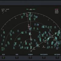
The AirTrack plug-in connects with the AirTrack app to track flights in real time over a local wireless network, offering built-in parameter reporting, an EFIS MFD, an FMC and airport information. …

This PDF checklist covers the 7W Executive's operations from dark and cold to secured shutdown, including manifold pressure guidelines and RPM settings. Authored by Werner Schott, the 2004-era rend…

An Auckland addition updates the China Airlines flight plans, adding the city to the route set and marking a January 1, 2011 launch from Brisbane. The work is by Finn Harris, documenting the geogra…

By Carl Vokes, a file adds oil rig markers and overlays them on a mapping interface, using an icon courtesy of NDBC Observation. It also restores the image store file and, when available, provides …
Compatibility centers on EditVoicePack 4.x with EVPX40.ZIP, delivering airline callsigns for Abelag, Air Caledonie, Air Hamburg, Anadolijet, Mexicana, Dauria, Island Air, IzAir, FlyLAL, National Je…