Page 18
Searches the whole library — filter by sim & category on the results page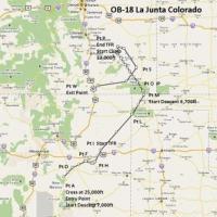
An IFR high-speed, low-altitude route begins near La Junta, Colorado, weaving through New Mexico, Texas, Oklahoma, and central Colorado, designed by Bill McClellan. Terrain Following Radar and Pave…
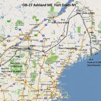
OB-27 Ashland to Fort Drum traces a fast, low altitude training route through Maine, New Hampshire, Vermont, and New York as the fifth flight plan in the series. Two gauges by Karol Chlebowski for …

Two AN26B airframes, UR-AFS and UR-AUA, operated by Air Sirin, fly from Nouadibou GQPP in Mauritania to GCLP, GOOY, GQNN, GVAC and LPFR, mainly carrying fish. Additionally, the airline conducts dan…
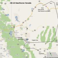
A freeware training corridor spans rugged ranges and expansive flats across California and Nevada, challenging high-speed low-level navigation. Two gauges by Karol Chlebowski - Terrain Following Ra…
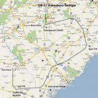
Operating near Statesboro, GA, OB-17 presents a high-speed, low-altitude route with rapid transitions, terrain-following segments, and sub-500-foot passes that test precision navigation. Two gauges…

Antoine Calleja authors flight plans for the Aviacon Zitotrans Ilyushin IL-76 fleet, with globusworld credited, detailing the operator and aircraft family and outlining the scope of planning consid…
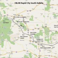
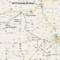
Bill McClellan develops a high-speed IFR routing spanning elevations in South Dakota, Nebraska, Wyoming, and Montana, with two Karol Chlebowski gauges, Terrain Following Radar and Pave Tack. Two ta…
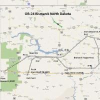
Bill McClellan develops the eleventh installment in a line of military-style routes, presenting the OB-24 corridor across the Bismarck region in North Dakota for IFR high-speed, low-altitude traini…

The LIC Christen Eagle thumbnail.jpg images, labeled LICEAGII.ZIP, link to the LICEagle_II folder. The author captures multiple aircraft variants, crops screenshots to 512×256 around the plane, the…

Flight plans for Skytrans Airlines are valid as of 1 July 2009, with Cairns-based operations expanding to Brisbane. Two aircraft variants appear: a Dash 8 from Project AI credited to Mal Lloyd and …
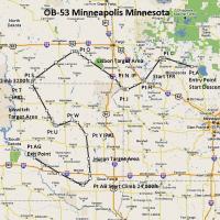
IFR high-speed, low-altitude routing traverses Minnesota, North Dakota, and South Dakota along the OB-53 corridor, featuring three distinct target sets. Two custom Karol Chlebowski gauges, Terrain …
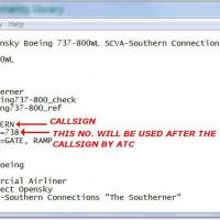
Paul Craig delivers a precise EditVoicepack asset for the SOUTHERN callsign. The core file, Southern Callsign.evpmod, pairs with EditVoicepackX, and a typical usage alters each aircraft.cfg by inse…
Across Missouri, Kansas, and Nebraska, the central US high-speed, low-altitude IFR route operates as the sixth installment, integrating Karol Chlebowski’s Terrain-Following Radar gauge with the Pav…
External camera views expand the Scout 2007 package, presenting four distinct perspectives. By Ryan Butterworth, this addition requires backing up all aircraft.cfg files in RealAir Scout, Decathlon…

An addition to EditVoicepack 4, it integrates the AirPhil Express asset using the import function of EditVoicepack 4.0, and it pairs the AirPhil Express Logo with this asset to establish a consiste…

By Yvan Greenaway, a Donghai Air callsign variant aligns with Donghai Airlines. It relies on Editvoicepack X, using EVPX40.ZIP, to activate the callsign and integrate the Donghai Airlines voice pro…

East Wing operates three Il-76s, registered UP-I7621, UP-I7623, and UP-I7624, based in Dubai. The identifiers, aligned with the Dubai base, anchor the profile and guide any reader through the airfr…
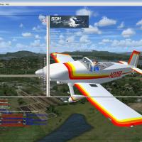
An image depicts the Thorp T-18 aircraft with registration N2056 (Robert), identified as the background element in a themed presentation by Michael Mannschreck. The background emphasizes a single-a…
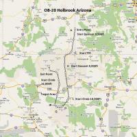
The fourth in a specialized series by Bill McClellan focuses on a low-altitude, high-speed IFR corridor across Colorado, Utah, and Arizona near Holbrook. It features gauges by Karol Chlebowski for …
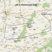
Bill McClellan presents a high-speed, low-altitude training path near Richmond, Kentucky, designed for heavy bombers and fast jets with IFR realism and terrain-following navigation. Two gauges by K…