Australia

Page 2

Sort
Reset
Preview screenshot

Gold Coast Airport

Covering YBCG Gold Coast Airport for FSX, this Australian scenery brings updated 2500 m runway data, custom Gmax and FSDS structures, the Coolangatta lighthouse beacon, apron floodlighting and photoreal shoreline revisions stretching to Byron Bay; Surfers Paradise high-rise, canal systems and ancillary hangars render with draw-call-friendly geometry for steady frame rates.

File Size
12.26 MB
Total Downloads
2.2K
Star Rating
2/5
Preview screenshot

Ants Aussie Airports Vol. 4

Covering Darwin International (YPDN), Royal Darwin Hospital’s pad and the rotary-wing stands at Robertson Barracks, Ants Aussie Airports Vol 4 supplies FSX pilots with geo-referenced photoreal ground tiles tuned for ORBX FTX Australia, bespoke 3-D assets and corrected AFCAD data, adding civilian, RAAF and medevac traffic realism to Northern Territory circuits.

File Size
47.5 MB
Total Downloads
2.2K
Preview screenshot

AFCAD For YBBN

FSX AFCAD for Brisbane International Airport (YBBN) updates the default Queensland scenery with optional cross-wind runway activation, current stand assignments across domestic and international piers, corrected PAPI lighting, revised taxiway signage, new service roads, animated jetway extensions, and a control-tower camera point that supports realistic AI sequencing and standardized SID/STAR routing.

File Size
661.59 KB
Total Downloads
1.6K
Screenshots
4
No image available.

Queensland Airport Pack 2

Queensland Airport Pack 2 updates ten disparate aerodromes across Australia’s Sunshine State for Microsoft Flight Simulator X, using Google Earth overlays and Airservices Australia charts to refine runway profiles, parking stands, taxi networks and shoreline vectors at Archerfield, Cairns, Bundaberg, Caboolture and outback or island strips such as Betoota, Boigu and Brampton.

File Size
39.83 KB
Total Downloads
1.4K
Preview screenshot

Perth International Airport

FSX users gain a refreshed rendition of Perth International Airport (YPPH) in Western Australia, adding ADE-crafted taxiway links, extra stands, optional 6/24 crosswind activation, and a revised tower model. Both AI pathing and fuel-truck routing are tuned, delivering smoother ground operations without departing from stock performance.

File Size
49.66 KB
Total Downloads
1.4K
Preview screenshot

Bathurst - Mount Panorama

Covering Bathurst in regional New South Wales, this photoreal package for Microsoft Flight Simulator X layers 60 cm orthoimagery, refined elevation mesh and hand-placed autogen across YBTH plus the Mount Panorama motor-racing circuit, providing reliable VFR landmarks and coherent IFR approach cues while maintaining smooth frame rates over the township and rural fringe.

File Size
294.08 MB
Total Downloads
1K
Star Rating
5/5
Screenshots
7
Preview screenshot

Norfolk Island Photoreal

Covering Norfolk Island in Microsoft Flight Simulator X, this photoreal scenery package supplies 1 m/pixel orthoimagery, refined airport layout, dense autogen, high-resolution terrain mesh and custom waterclass, giving Australian regional flyers a seamless VFR reference. Compatible with FSX SP2 and Acceleration.

File Size
43.86 MB
Total Downloads
1K
Screenshots
15
No image available.

Victorian Airport Pack One

Covering ten upgraded aerodromes across regional Victoria, this FSX scenery bundle refreshes Avalon YMAV, Bendigo YBDG, Boort YBBT, Cobden YCDE, Barwon Heads YBRS, plus Bridgewater YBGR, Birchip YBIR, Bairnsdale YBNS, Bacchus Marsh YBSS and Colac YOLA, adding revised runway profiles, corrected taxiway geometry and geo-referenced landclass to give Australian VFR and IFR operations greater positional accuracy.

File Size
21.86 KB
Total Downloads
975
Star Rating
1/5
Preview screenshot

Lord Howe Island

Covering Australia’s remote Lord Howe Island, this FSX scenery add-on replaces default data with precise coastlines, SRTM-derived 90 m terrain mesh, revised landclass and waterclass, enhanced YLHI airport layout, a Gmax-built Balls Pyramid landmark and AI boat routes, giving VFR pilots accurate visual references and IFR flyers correct navaids.

File Size
604.7 KB
Total Downloads
930
Star Rating
4/5
Preview screenshot

Ballina Byron Gateway Airport

Ballina Byron Gateway Airport scenery for Microsoft Flight Simulator X provides a complete airfield layout for New South Wales’ Northern Rivers hub, pairing 60 cm-per-pixel runway textures with 1 m photoreal terrain spanning Ballina to Byron Bay. Custom structures, T-VASIS lighting, landclass autogen and an accurately marked 1 900 m strip accommodate 737-class operations.

File Size
273.02 MB
Total Downloads
886
Star Rating
5/5
No image available.

West Australian Airport Pack

Covering ten varied aerodromes across Western Australia—from the iron-ore strip at Brockman to coastal Busselton and the remote Christmas Island—this airport pack updates Microsoft Flight Simulator X (FSX) with precise runway geometry, revised navaids, corrected elevations, AFCAD parking spots and AI-aware taxi routing for credible VFR and IFR procedures.

File Size
22.22 KB
Total Downloads
805
Preview screenshot

YSCB

Ray Smith’s AFCAD for Canberra Airport (YSCB) revises the FSX default with accurate runway 17/35 dimensions, elective cross-wind activation, realistic stand allocations and corrected taxiway signage; tower viewpoint, vehicle routes and AI traffic flows are tuned to current Australian AIP data, enabling balanced domestic-international operations without extra scenery libraries.

File Size
402 KB
Total Downloads
777
Screenshots
2
No image available.

New South Wales Airport Pack

Spanning Armidale YARM, Broken Hill YBHI, Albury YMAY and eight further rural strips, this New South Wales Airport Pack revises the default Microsoft Flight Simulator X scenery with recalibrated AFCADs, accurate runway geometry, updated navaids, realistic parking, photoreal placement and data cross-checked against Airservices Australia charts and Google Earth.

File Size
27.61 KB
Total Downloads
759
No image available.

Queensland Airport Pack Three

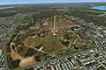
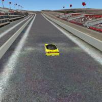
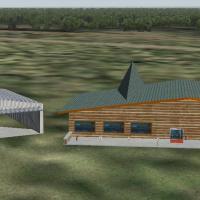
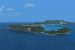
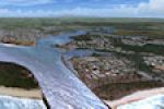
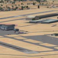
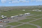
Queensland Airport Pack Three brings ten regional hubs and outback strips—YBCV, YCCY, YCDR, YCEL, YCFN, YCGO, YCHT, YCMT, YCMW and YCNY—into focus with Google Earth checks and Airservices Australia charts, adding accurate runway geometry, AFCAD updates, refined aprons, taxiway lighting for Microsoft Flight Simulator X pilots flying VFR or IFR across Sunshine Coast, Gulf Country and western Queensland.

File Size
22.33 KB
Total Downloads
727
Preview screenshot

Six Airports In NSW, Australia

Anthony Lynch’s FSX pack charts six varied New South Wales aerodromes—Casino, Evans Head, South Grafton, Wedderburn, Wilton and private strip Gundaroo—layering photoreal ground polys that blend seamlessly with ORBX FTX terrain, supported by nearly all-custom object libraries, dynamic windsocks and accurate airport data for smooth VFR circuits across regional Australia.

File Size
61.06 MB
Total Downloads
669
Preview screenshot

Melbourne International Airport

This Australian add-on scenery module revises Melbourne International Airport YMML for Flight Simulator X, introducing enlarged gate geometry for A380 and 747 operations, updated AFCAD parking positions with airline ICAO codes, and an optimised taxi network; compiled using FSX Planner and tested with VOZ and PAI AI traffic.

File Size
11.07 KB
Total Downloads
660
No image available.

Australia And Norfolk Island

Covering continental Australia and remote Norfolk Island, this FSX-specific landclass add-on refines terrain definition, softening harsh default desert palettes and introducing region-appropriate vegetation hues for spring, summer and autumn flights; a straightforward way for Microsoft Flight Simulator X pilots to gain truer outback, coastal and rainforest ground coloration.

File Size
2.48 MB
Total Downloads
642
Preview screenshot

YPPH

This FSX airport scenery AFCAD refresh for Perth International (YPPH) replaces the default layout with optional cross-wind runway logic, updated SID/STAR-ready taxiway geometry, A380-capable gates at Terminal 2, new apron, service roads, lit helipad and control-tower viewpoint for smoother AI traffic patterns throughout Western Australia.

File Size
671.01 KB
Total Downloads
595
Screenshots
4
No image available.

Brisbane West Wellcamp Airport

Serving Toowoomba and Queensland’s Darling Downs, this Brisbane West Wellcamp Airport (YBWW) add-on supplies FSX with precise runway and taxiway geometry, dual-direction ILS/DME, four stand-coded gates and GA parking, aligning nav-data, approach plates and ground markings for refined regional jet and turboprop operations.

File Size
3.18 KB
Total Downloads
589
Star Rating
1/5
Preview screenshot

Ants Aussie Airports Vol. 1

Covering Cooma-Snowy Mountains (YCOM), Polo Flat, Tumut (YTMU), Khancoban (YKHA), Geehi and Adaminaby’s Kennedy Field (YADY), Ants Aussie Airports Vol. 1 supplies FSX with high-resolution photoreal ground polygons, bespoke 3-D assets and updated AFCAD data, harmonised with ORBX FTX Australia for realistic bush, GA and charter workflows.

File Size
33.19 MB
Total Downloads
573

5 pages with 99 downloads.

previous12345next