Page 2
Searches the whole library — filter by sim & category on the results page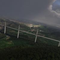
An accurate replica of the Millau Viaduct spans the Tarn gorge, paired with detailed surrounding terrain and fixed beacon lighting for night flights. The navigation coordinates 44°04'27.60" N 3°01'…
 France
Two dedicated builds cover Inverness EGPE for the simulator’s 2020 and 2024 generations, featuring hand-crafted terminal and control tower, plus cargo structures such as Co-op and UPS. Landside con…
 United Kingdom
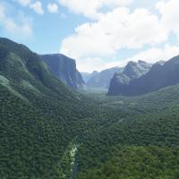
VFXSimmer delivers refined terrain and feature representation for Yosemite Valley in California, including El Capitan, Half Dome, Glacier Point, Bridalveil Falls, Yosemite Falls, and Vernal & Nevad…
 United States of America
Version 3.0, created by Jeppeson2001, models Monument Valley across the USA region with three files named monumentvalley, monumentvalleyvc, and monumentvalleytiles. It blends into the World Update …
United States of America
Keith Hackett and Kevin Base lead a hand-crafted, manually placed series of UK piers, created without AI or automation. Saltburn pier features animations and night lighting and overrides the ORBX G…
United Kingdom
Swiss Airfield Crafters focuses on function and accuracy for Swiss airfields, delivering very accurate renditions of Sitterdorf LSZV, Winterthur LSPH, and Kägiswil LSPG. Separate BGL files exist fo…
 Switzerland
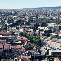
Version 3.0 by AndrianLScenery reshapes the Dijon, France area for the 2020 edition, using 19 cm per tile HD textures and revised terraforming data, and adds CHU Hospital Heliport while preserving …
France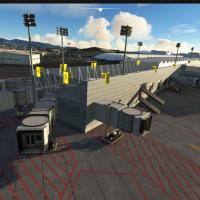
Two terminal models anchor this project, with Terminal 1 gates 1–8 and international gates, plus Terminal 2 featuring a control tower replica after SENEAM and a National Guard hangar. Compiled with…
 Mexico
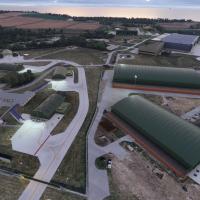
Across Lossiemouth, identified by EGQS, on Scotland’s northeast coast, nickb007 delivers a contemporary base layout with Poseidon MRA1 facilities and Typhoon FGR4 and P-8A assets by Nattani. Proxim…
United Kingdom
KFXE shows custom-modeled Administration Building, presenting a meticulous representation. Enhanced lighting around key structures and a freeware add-on using the latest SDK accompany the overall d…
United States of America
By Joshua Gerard, the project recreates a now-closed STOLport south of Magic Kingdom, originally opening in 1971. The 2000 by 100 foot runway hosts four parking spots, while the apron remains large…
United States of America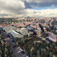
Steveli recreates Prague’s entire urban area using newer photogrammetric data, with 3D building models and enhanced color corrections that raise detail to LOD20. A single download contains five par…
 Czechia
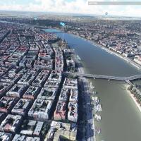
Budapest city overhaul for the 2020 edition, by steveli, reaches version 1.2 and relies on high-definition satellite imagery with LOD20. Three folders budapest_n, budapest_n1, and budapest_s anchor…
 Hungary
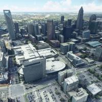
By Thalixte, a drop-in replacement for the Charlotte area provides photogrammetry and detailed 3D models of buildings and landmarks. It partitions the region into five named zones—Downtown, East, N…
United States of America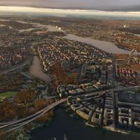
By Thalixte, this Stockholm enhancement is the second version titled Enhanced and comes in two folders named thalixte-stockholm1 and thalixte-stockholm2, centered at 59.3293° N, 18.0686° E. It uses…
 Sweden
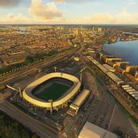
Developers replace the Rotterdam region's ground surface and terrain elevation with higher-detail data sourced externally and add 3D building data for a denser urban layout, while the release spans…
 Netherlands
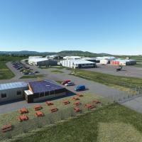
Near Gloucester and Cheltenham in the UK, this add-on recreates Gloucestershire Airport with forty custom hangar models reflecting the real layout. It centers on active runways 09/27 and 04/22, not…
United Kingdom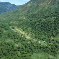
Using a custom object library pbk-huts-n-stuff, 88 airstrips in Highland Papua, Indonesia receive updates, while 20 additional strips stay not included in the base lineup. Google Earth and OurAirpo…
 Papua New Guinea
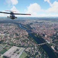
By Thalixte, the thalixte-albi file adds 3D city modeling and photoreal ground imagery across the entire Albi area, delivering a complete freeware enhancement for the region. Coordinates 43°50'16.8…
France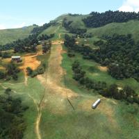
Owena airstrip AYWW in PNG presents a 1000-foot dirt runway with gradients from 13% at the midsection to 17% at the top, and the approach is advised from the west due to surrounding terrain. A blen…
Papua New Guinea