Page 78
Searches the whole library — filter by sim & category on the results page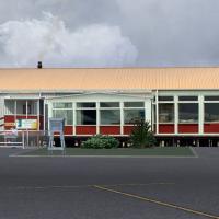
Custom 3D buildings accompany NZCI at the Chatham Islands and rely on CGTextures-created textures; the work sits best with a 20 meter mesh add-on. By Michael Allen-Andrews, it is freeware, and its …
 New Zealand
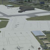
An airport modification at KMDT in Pennsylvania updates terminal gates, gate assignments, and approach data to May 2010 specifications, adds Runway 13 lighting and apron lights, and introduces a ne…
 United States of America
RJBD Ryujin, by Kenichi Ochiai, presents a detailed portrayal of the Ryujin spa area in Japan in version 2.2. Its geographic focus remains Japan, with attention to the Ryujin area, and the attribut…
 Japan
Japan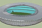
An urban arena model in Cape Town, this freeware depiction focuses on a stadium constructed for the 2010 FIFA World Cup in South Africa. It originates from a custom designed object and credits Phil…
 South Africa
Fifty-one airfields span Portugal from north to south, with ultralight aviation accounting for the vast majority of use. ADE9X serves as the base, and Jorge Ferreira is credited as the author, with…
 Portugal
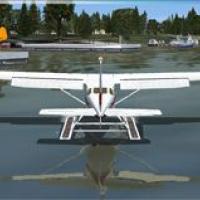
A private seaplane facility on Lake Cannon comprises 2 acres and lies about two miles northwest of Winter Haven, Florida, with coordinates N28°2.32' / W81°45.22' and an elevation of 133 feet MSL. A…
United States of AmericaZadar runway 14 hosts ILS with frequency 110.1 and an outer marker, by Karl Sorowka. The approach starts at 2300 ft, passes the outer marker at 1710 ft, and uses a 443 ft decision altitude; missed …
 Croatia
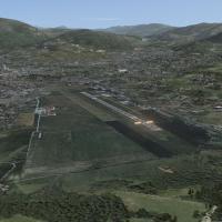
Foligno Airport in Italy hosts a depiction by Marco Piovani, tied to the MP Servizi Aerei Virtuali hub and linked to Foligno 2009. This piece depicts a complete representation of Foligno's faciliti…
 Italy
Italy
KPVD in Providence, Rhode Island receives revisions by Kyle Cormier that include corrected gate assignments for airlines and cargo servicing PVD, aligning the field with real-world operations. The …
United States of AmericaBy Cesar Marinho, two BGL files, CVX0304.BGL and APX27320.BGL, adjust altitude at SEMC and SESC airports in the Equator region. The work targets mesh corrections for those locations and remains lim…
 Global (World)
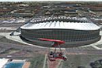
Moses Mabhida in Durban is a World Cup–aligned stadium model created for the 2010 event in South Africa. It remains freeware and fuses a custom-designed approach with a photoreal base, credited to …
South Africa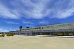
EHBK Maastricht Aachen Airport is modeled within NL2000 v4.03, aligning with local topography and architecture to reflect ground layouts, distinctive structures, and signage. It requires NL2000 v4.…
 Netherlands
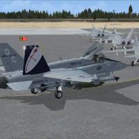
Ryan Cobb reworks Beaufort KNBC, the MCAS in South Carolina known as Fighter Town USA on the East Coast. Two BGL files replace the default layout, while the original buildings get a thorough redo, …
United States of America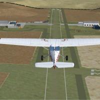
Denham crafts a UK airfields collection's twelfth release, upgrading two grass strips 06/24 and 15/33 with 800 ft circuits, featuring left-hand patterns on 24 and 33 and right-hand on 06 and 15. Ar…
 United Kingdom
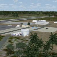
Situated as the Bahamas’ southernmost airport, MYIG is relocated to its true position with custom objects and landclass adjustments. The project uses Google Earth and Bing imagery with local photos…
 Bahamas
Colorado hosts eight airports and marks the seventh installment in the Pro Hops fictional airstrip series, with lights for night hops. Starseed Productions LLC distributes for Red Eye Guys Inc., wi…
United States of America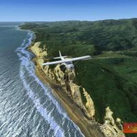
A photoreal landscape for Abel Tasman spans about 320 square miles at the northern tip of New Zealand’s South Island, by Micheal Allen-Andrews as the freeware author. National Park is referenced, a…
New Zealand
Potomac Airfield (KVKX) sits in Fort Washington, Maryland, a privately owned public-use field inside the FRZ of the Washington DC ADIZ, requiring security clearance to operate. Hangars and FCLP mar…
United States of America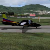
By Andres Ramirez, the entry presents two images focused on a Colombian airfield, showing a stationary plane and a plane during landing. Captions reference the locale, while the visuals capture the…
 Colombia
Two BGL variants update the default Schwechat airport, including animated jetbridges at terminals A and C, assigned parking, rebuilt service roads, extra fuel trucks, and a helipad. The FSX_loww_cw…
 Austria