Page 4
Searches the whole library — filter by sim & category on the results page
Nickb007 delivers a KBKF upgrade with a custom control tower and a static lineup including F-16C fighters from the 140th Wing and a CH-47 Chinook around the Denver–Aurora area. Version 1.02 removes…
 United States of America
BWJ in Papua New Guinea presents a 755-foot strip perched in a hillside at 4500 feet, located about 12 nautical miles northeast of Nadzab regional airport. The pbk-bawan-bwj name marks the file, an…
 Papua New Guinea
Two variants exist, an HD version and a standard one, with the HD folders thalixte-lyon-hd1 and thalixte-lyon-hd2, while the standard uses thalixte-lyon. Photogrammetry, based on Google Maps 3D dat…
 France
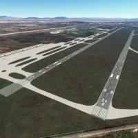
In a flight simulator, a freeware enhancement adds AIFA near Mexico City with true-to-life runways 04C and 04R, plus a comprehensive taxiway network and distinct commercial and military parking are…
 Mexico
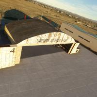
A fully custom 3D model of Gravricks Hangar at KIYK in Inyokern, CA features interior and exterior work rendered in 4K with PBR lighting. Doors are fully animated and triggerable within 250 meters …
United States of America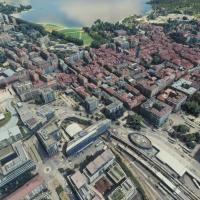
Two dedicated folders, thalixte-annecy and thalixte-menthon, deliver a photogrammetry representation of Annecy with high-resolution city details, including the basilica and palace, and integrated P…
France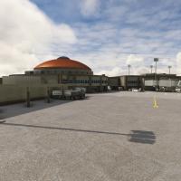
Lovell Field, designated KCHA, is presented with bespoke 3D models of the terminal and tower that echo the airport's distinctive architecture. Night flood lighting enhances operations after dusk an…
United States of America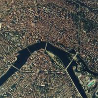
High-resolution photogrammetry renders Toulouse with precise 3D representations of buildings and landmarks, including the Basilica of St. Sernin, the City of Space, and Toulouse–Blagnac Airport (LF…
France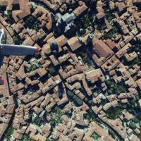
Two folders, thalixte-bergamo1 and thalixte-bergamo2, present Bergamo in two parts, covering Città Alta and the city, aligned to coordinates 45° 41? 42? N, 9° 40? 12? E. It uses photogrammetry data…
 Italy
Italy
Expanded photogrammetry, via thalixte-larochelle, covers La Rochelle with updated colorimetry, including La Pallice harbor and Les Minimes marina, while improved road traffic, procedural lighting, …
France
Version 1.1 adds elevation adjustments for a seamless blend with the nearby Gibraltar photogrammetry asset, while detailing the Port of Algeciras and outlining the urban layout along the Río de la …
 Spain
Spain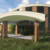
Developed by RaptrFlite, this KUNI airport enhancement presents day and night modes, functional fuel pumps with a fuel truck, and a Douglas DC-3 Gooney Bird bearing Ohio University branding. Mesh u…
United States of America
Freeware development for Gral. Abelardo L. Rodriguez International Airport in Tijuana adds a custom terminal and a modeled control tower, plus an Avolar hangar, reflecting the real-world airport's …
Mexico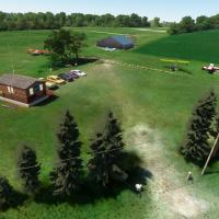
Castillonnès LF4722 at 44°41′55″N, 0°38′20″E sits 394 feet above sea level and provides a 123.500 MHz radio channel for traffic coordination; fuel is available on request. Microlights must complete…
France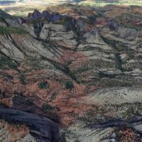
The Zion Canyon area in Utah receives a 2020 edition overhaul, introducing photorealistic visuals sourced externally and corrected terrain height around East Temple to better reflect the real lands…
United States of America
JustOkayPilot delivers a KGCN airfield near Tusayan, Arizona, located about seven miles from the South Rim, featuring 3D hangars, terminals, animated vehicles, and surrounding roads with vegetation…
United States of America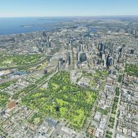
By HamerheadH, this Melbourne, AU city package advances the urban area to version 2.0, stitching map data into the layout. Two resolution options exist, with the melbourne-hd and melbourne-standard…
 Australia
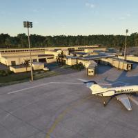
KGNV in Florida, USA, features 100% custom buildings and new jetways, with cars and trucks filling parking lots and lighting in parking areas, while aprons, taxiways, runways, and takeoff procedure…
United States of America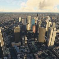
Two variants are available, the standard version and a no-handcrafted-models version, identified by thalixte-frankfurt and thalixte-frankfurt-no-handcrafted-models folders. The data totals over 1.5…
 Germany
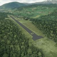
By Augustin Winther, the Norwegian general aviation airfield near Vossevangen in Voss Municipality, Vestland, receives a daylight-only, visual-flight-rule rendition not present in the base game. In…
 Norway