Page 108
Searches the whole library — filter by sim & category on the results page
By Frits Beyer, a V2.0 edition covers South Africa’s power facilities and adds a custom building at Orlando powerstation, while the initial version is removed in favor of this configuration. The ch…
 South Africa
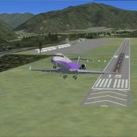
Phillip Coyle creates a KASE enhancement for the Aspen-area airport, using real-world dimensions derived from Google Earth and adding a few objects from the default libraries. Two BGL files, KASE_A…
 United States of America
The Bremerton facility at KPWT in Washington state shows the airport with structures such as buildings, a hangar and parking areas. Two image presentations accompany the entry, illustrating the lay…
United States of America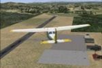
Cesar Marinho Costa presents an enhancement for SNGX in Guaxupe, Minas Gerais, Brazil, adding details to Guaxupe Airport and including communications such as Broadcast Guaranesia (GUA) on 1580 and …
 Brazil
Private aerodromes east of Pretoria include Zyn Kraal and Rhino Park beside Kittyhawk estate. Kittyhawk receives an updated ground layout with taxiways and hangers, while Zyn Kraal has no ICAO ID y…
South AfricaLocated south of Aylesbury, Buckinghamshire, UK, RAF Halton hosts the RAFGSA Chilterns Gliding Centre along with the Halton AeroClub and Halton Microlight Club. The Virtual Flying Club team deliver…
 United Kingdom
Cardiff patch for EGFF in the UK accompanies CARDIFF.ZIP. It deletes egfffence.bgl and replaces egfftank.bgl to stop a crash at the fuel tanks, and adds two new fuelshed-fuelshed_lm files into the …
United Kingdom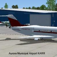
Aurora city airport, designated KARR, serves Chicago area and Kane County, with a paved main runway measuring 6500 feet at 706 feet elevation, located about 38 miles from Chicago. Greater Kankakee …
United States of America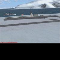
Longyearbyen Airport in Svalbard, Norway (ENSB) gains ATC, buses, and gates by integrating with the existing layout today. Airport Design Editor 9x shapes ENSB_ADEX_TH, the addon file that expands …
 Norway
At KBMI in Bloomington-Normal, gates and parking areas receive enhancements, and jetways are visible and operable, with CNTRL-J calling jetways to the aircraft. The facility serves Airtran, Delta C…
United States of America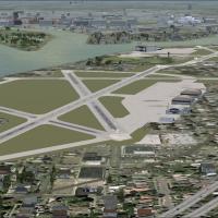
This Washington-area add-on revisits Bolling AFB and Anacostia NAS after fixed-wing traffic ends in 1962 as Navy and Air Force operations shift to Andrews AFB. A file named AFX_KBOF_ALT.bgl is desc…
United States of America
Roberto Ayala provides original terminal buildings for Vieques (TJVQ), Fajardo (TJFA), and Culebra (CPX) on Puerto Rico, reflecting the island's eastern air routes. Eastern Puerto Rico includes Vie…
 Puerto Rico
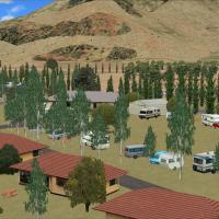
Based in New Zealand (NZOA), this Omarama-area addition highlights the Glider Capital of New Zealand, placed about 1 km from the town and 10 nautical miles west-northwest of the Benmore Dam. It rel…
 New Zealand
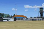
Groningen Airport Eelde (EHGG) benefits from a modular add-on that integrates with NL2000 v4 assets to deliver authentic layouts and refined ground treatments. It details accurate runway coordinate…
 Netherlands
A Manitoba floatplane network encompasses 55 bases, including 36 floatplane bases, 6 heliports, 13 airports or airstrips, plus 12 unlisted floatplane bases and outposts and 3 unlisted airstrips, sp…
 Canada
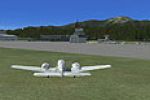
Aaron Bennett creates a California airfield at Big Bear as an asset, establishing the location and author clearly. An accompanying JPG image provides a visual reference through a screenshot, confir…
United States of AmericaFrits Beyer creates a near-Cape Town facility, with John contributing to the towers' scale, and the project clarifies that it is not the real site. It improves your flying in Cape Town, South Afric…
South Africa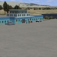
By Jacques Botha, it centers on the OAUZ Kunduz location, featuring custom models with photo-based visuals that change with the seasons. The Kunduz_Afghanistan folder and the AFX_OAUZ_ALT.bgl file …
 Afghanistan
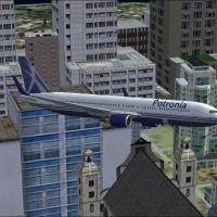
Edition adds the city back and introduces a new airfield. Credits go to Orlandy Perez and Wayne Jarrett, and the effort centers on a folder named Potronia, with a screenshot depicting a plane on th…
 Global (World)
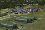
In Neuchateau, France, a patch by D. Bur introduces a new main BGL for the LFFT project, eliminating shadow bugs and removing tall trees too close to runway ends. It requires LFFT_FSX.ZIP and lists…
 France