
FSX Lumberjack applies autogen-exclusion polygons to strip away surplus foliage around every stock aerodrome in Flight Simulator X, clearing three- or five-times the runway width and one-and-a-half…
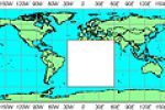
Covering the entire African continent, Raimondo Taburet’s FSX SRTM3 v2 terrain mesh delivers updated 3-arc-second elevation data across deserts, highlands and coastal basins, packaged in a single d…
Consolidating all five “Interzone” releases, this FSX texture pack upgrades transitional terrain—belts between treeline and alpine slopes—with 50 cm-per-pixel, multi-season photoreal imagery, refin…
Targeted at UK flyers, this performance tweak reduces and re-labels Microsoft Flight Simulator X autogen texture bitmaps, lowering GPU load over British terrain. Pilots typically gain around six ex…
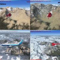
This 30 cm rock and mountain texture set upgrades default Flight Simulator X geology from the older 1 m resolution to sharper quarter-meter photoreal imagery, supplying summer-season DDS replacemen…
Low-key package of revised BGLs cleans up misplaced objects, bad elevation data and runway incursions across several U.S. airfields, resolving terrain mesh tears, autogen clutter, obstacle-clearanc…
‘Stan’ AFCAD Pack 1 augments FSX default layouts at Ashgabat UTAA, Turkmenabat UTAV, Dushanbe UTDD and Tashkent UTTT with re-profiled gates, added cargo stands, adjusted fuel-truck nodes and correc…
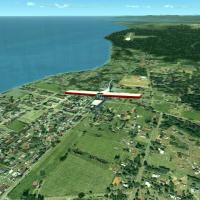
Covering freight corridors from Dakar to Lagos, West Africa Freight Ltd. for FSX adds hand-placed autogen, bespoke AFCAD layouts, realistic .BGL objects and photoreal ground polys, supporting cargo…
Covering Aquatica (WET2), Eden Hollow (EDEN), Highasara (VE44) and HL67 Gamal Abd El Nasser, this Microsoft Flight Simulator X set revises runway geometry, updates apron markings, injects additiona…
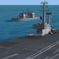
For Microsoft Flight Simulator X, this AI ship scenery injects moving carrier battle groups—Nimitz-class decks, support vessels and escort destroyers—along routes off Norfolk, San Diego, Oahu, Napl…
Targeting Alberta, British Columbia and Alaska, this FSX batch-based ground-texture tweak reassigns stock landclass bitmaps to replace pale desert tiles with darker rock, greener alpine bases and m…
Covering the British Isles’ energy network, FSX Power Project V4 populates Microsoft Flight Simulator X with animated wind turbines, coastal wind farms, cooling-tower steam, accurately aligned elec…
Covering St Vincent, the Grenadines and neighbouring Grenada, this FSX SP2 add-on blends a LOD10 Caraïbes mesh with updated vector roads, re-drawn shoreline data and custom landclass, while overhau…
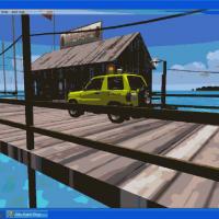
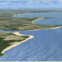
Covering Cocoa Beach HQ down to Key West docks and onward to Bimini and Havana, this Microsoft Flight Simulator X scenery set portrays Caribbean Seaplane Tours’ fictional network with hardened wate…
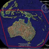
SRTM-derived terrain mesh refines Australia’s topography in FSX with 3-arc-second (≈76 m) resolution, void-filled elevation data and corrected contours, yielding cleaner ridgelines, crisper escarpm…
Covering Iguazú Falls and the tri-border zone, this FSX package layers 5 m custom mesh, photoreal satellite imagery and hand-drawn landclass to shape the cataracts, Itaipu hydroelectric complex, Fr…
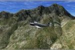
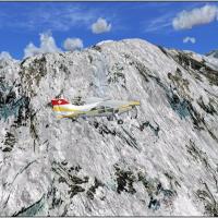
Alpine 38 m terrain mesh for FSX supplies detailed DEM relief across Switzerland’s highlands and adjacent ranges, built via FSX SDK with graduated LOD to retain smooth frame rates; a practical upgr…
Covering Grand Cayman, Jamaica, Cancun, Curaçao, Bonaire, Roatán and La Orchila, this Microsoft Flight Simulator X scenery pack layers bespoke seaplane docks, water runways, harbor lighting, accura…
Targeted at Microsoft Flight Simulator X users flying the South African sector, this Aeroworx v2 freeware terrain upgrade layers cleaned vector roads, railways, hydrography, landclass tiles and hig…
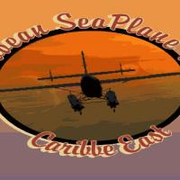
Covering twenty island strips from Puerto Rico down to Tobago, ‘Caribbe East’ scenery pack delivers dockable water runways, updated terrain mesh, refined AFCAD layouts, fresh VOR/NDB references and…

