
FSX users flying Egypt’s Hurghada International (HEGN) gain an updated AFCAD that expands cargo aprons, re-indexes gate numbering, refines fuel-truck nodes, and balances heavy-jet, regional, and GA…
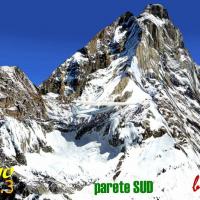
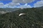
V3 build of the FSX Matterhorn photoreal scenery injects high-definition 1 m terrain tiles across the Italian-Swiss alpine ridge, employing custom vertical mapping that curbs slope stretching while…
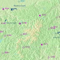
This FSX add-on recreates the 1943 Dambusters sortie with a geo-accurate RAF Scampton airfield, photo-real terrain around the Moehne, Eder and Sorpe dams, bespoke night lighting, custom elevation m…
FSX Harbours for Southern Africa Scenery refines coastal ports, inland dams, and signature bridges from Bloukrans to Ruacana, pairing custom models with Aeroworx mesh for accurate elevations, solid…
Covering OR Tambo FAJS, Rand FAGM, Virginia FAVG, Krugersdorp FAKG, Tzaneen FATT and more, this South Africa airport pack updates taxiway designators, slabbed aprons and surrounding Highveld terrai…
FSX AFCAD Pack 3 supplies revised parking charts for Muscat OOMS, adding cargo bays, fuel truck nodes and balanced priority codes; files also tweak Shiraz OISS, Esfahan OIFM and Bandar Abbas OIKB t…
South-American terrain mesh for Microsoft Flight Simulator X revises the digital elevation model along the Peru–Ecuador frontier, applying altitude fixes at SEMC and SESC via replacement CVX0304.BG…
This FSX scenery injects precise dam walls throughout South Africa, Namibia, Botswana and nearby regions, offering VFR pilots reliable hydrological landmarks keyed to Aeroworx 0604–0705 terrain mes…
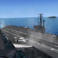
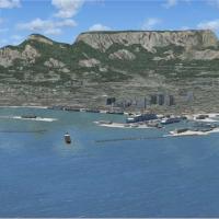
This freeware addon deploys a compact naval task group of AI aircraft carriers and escort vessels off the coast, enabling catapult launches, arrested recoveries, and realistic naval traffic pattern…
Compact autogen texture pack for Microsoft Flight Simulator X halves bitmap dimensions to 512 × 512 DDS with full mip-maps, dropping each file from 683 kB to 171 kB; the reduced memory footprint cu…
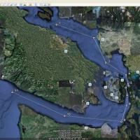
FSX Carrier Tracks Volumes 1–2 adds dynamic Nimitz-class and Clemenceau AI carrier traffic to coastal zones at Oahu, San Diego, Juan de Fuca, Pensacola, Key West, Oceana, Corpus Christi, plus Cuba,…
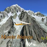
Mont Blanc Photorealistic Scenery for FSX brings a high-resolution aerial texture set to the French-Italian Alpine sector, overlaying 2 m imagery for crisp snowfields, stratified rock faces and aut…
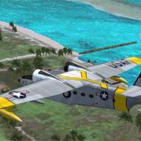
Covering Ham Tan, Cheo Reo, Quang Ngai and RAAF Luscombe strip, this FSX add-on extends the Vietnam War Project base package with upgraded object libraries, AI schedules, rotary-wing fuel spots, a …
Covering Jalalabad to Parachinar, this FSX package drops a detailed combat arena into the Afghan–Pakistani borderlands, adding forward operating bases, moving AI convoy traffic, SAM emplacements an…
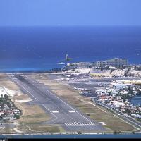
Covering 57 cays across the Virgin and Leeward archipelagos, this FSX add-on delivers reshaped mesh, resized runways, updated radionav aids and corrected shorelines for dependable VFR work and IFR …
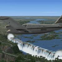
Covering Victoria Falls on the Zimbabwe–Zambia frontier plus Lambert’s Bay Caravan Park and Marromeu Airfield (FQ01), this Southern Africa scenery pack for FSX supplies 1 m mesh-matched photoreal t…
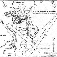
Covering Okinawa’s Kerama Retto anchorage and 12 supplementary Pacific waypoints, this WWII-era FSX scenery positions USS Bering Strait AVP-34 and seven attendant seaplane tenders with coordinated …
Geared toward FSX pilots seeking crisper woodlands, this 50 cm Generic Project Forests texture package (parts 1-3) swaps the stock 1 m bitmaps for 0.5 m multi-season photoreal coverage, enhancing c…
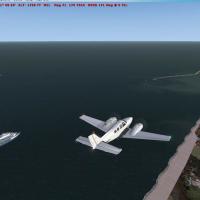
FSX English Channel Ships Scenery positions roughly 60 static vessels—container carriers, VLCC tankers, ferries and cruise liners—along the real-world Dover-Calais traffic separation scheme, using …
Utility poles and streetlights populate FSX’s U.S. vector roads through a revised terrain.cfg, adding obstruction-height data and subtle night luminance along interstates, rural highways and suburb…

